
Booderee National Park and Botanic Gardens are located in the Jervis Bay Territory of Australia. The reserve is composed of two sections:

Huskisson is a town in New South Wales, Australia in the City of Shoalhaven, on the shores of Jervis Bay. It is 24 km south-east of Nowra.
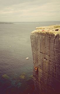
Beecroft Peninsula is the northern headland of Jervis Bay, on Australia's east coast. On the western and southern sides of the peninsula steep sandstone cliffs rise out of the ocean, up to 91 metres at its southernmost point, Point Perpendicular. White sandy beaches are found along the northern, eastern and southern sides interspersed with numerous intertidal reefs.
The Seat of Government Act 1908 was enacted by the Australian Government on 14 December 1908. The act selected the Yass-Queanbeyan region as the site for Canberra, the new capital city of Australia.
The Seat of Government Acceptance Act 1909 is an Australian Commonwealth Government act, that in conjunction with the Seat of Government Surrender Act 1909 transferred land from the state of New South Wales to the Commonwealth for the creation of the Federal Capital Territory.

The Seat of Government Surrender Act 1909 is a Act of the New South Wales Parliament which completed the transfer of land from New South Wales to establish the Federal Capital Territory as the seat of Commonwealth government. The Act became law on 14 December 1909, the day after the Seat of Government Acceptance Act 1909 had been passed by the Commonwealth government.
The Jervis Bay Territory Acceptance Act 1915 was an Act of the Parliament of Australia which followed the New South Wales Seat of Government Surrender Act 1915. The Act created the Territory of Jervis Bay, subject to the laws of the Federal Capital Territory (FCT). While the Act's use of the language of "annexed" is sometimes interpreted as implying that the Jervis Bay Territory was to form part of the Federal Capital Territory, the accepted legal position is that it has been a legally distinct territory from its creation, despite being subject to FCT/ACT law and being administratively treated as part of the FCT/ACT.
The Seat of Government Surrender Act 1915 was an Act of the New South Wales Parliament transferring land from New South Wales to establish the Jervis Bay Territory as part of the Federal Capital Territory. The Jervis Bay Territory Acceptance Act 1915 was the corresponding Commonwealth Act accepting the transfer of land.

Government in the Commonwealth of Australia is exercised on three levels: federal, states and territories, and local government.

The first colonies of the British Empire on the continent of Australia were the penal colony of New South Wales, founded in 1787, and the Swan River Colony, founded in 1829. Over the next few decades, the colonies of New Zealand, Queensland, South Australia, Van Diemen's Land, and Victoria were created from New South Wales, as well as an aborted Colony of North Australia. On 1 January 1901, these colonies, excepting New Zealand, became states in the Commonwealth of Australia. Since federation, the internal borders have remained mostly stable, except for the creation of some territories with limited self-government: the Northern Territory from South Australia, to govern the vast, sparsely populated centre of the country; the split of the Northern Territory into Central Australia and North Australia, and then the quick merger of those back into the Northern Territory; and the Australian Capital Territory, a federal district ceded from New South Wales.

Lands administrative divisions of Australia are the cadastral divisions of Australia for the purposes of identification of land to ensure security of land ownership. Most states term these divisions as counties, parishes, hundreds, and other terms. The eastern states of Queensland, New South Wales, Victoria and Tasmania were divided into counties and parishes in the 19th century, although the Tasmanian counties were renamed land districts in the 20th century. Parts of South Australia (south-east) and Western Australia (south-west) were similarly divided into counties, and there were also five counties in a small part of the Northern Territory. However South Australia has subdivisions of hundreds instead of parishes, along with the Northern Territory, which was part of South Australia when the hundreds were proclaimed. There were also formerly hundreds in Tasmania. There have been at least 600 counties, 544 hundreds and at least 15,692 parishes in Australia, but there are none of these units for most of the sparsely inhabited central and western parts of the country.

Murray County was one of the original Nineteen Counties in New South Wales and is now one of the 141 Lands administrative divisions of New South Wales. It included the area which is now part of Canberra and as far north as Lake George and Yass. It was originally bounded on the west by the Murrumbidgee River, on the east by the Shoalhaven River and on the north by the Yass River. A large area of the county was transferred to the Commonwealth government in 1909 in the Seat of Government Acceptance Act to make part of the Australian Capital Territory, along with land in Cowley County. Since then, the ACT border is now part of the western boundary. Part of the ACT border is determined by property boundaries in the Parish of Keewong, in the County of Murray; specifically the southern end of portions 177, 218, 211, 36, and 38. This is mentioned in the Seat of Government Acceptance Act of 1909.
Yarrolumla Parish is a former parish of Murray County, New South Wales, a cadastral unit for use on land titles. It was formed in the nineteenth century, and existed until 1 January 1911, when the Seat of Government (Administration) Act 1910 came into force, after the land was transferred to the Commonwealth government in 1909 to be used to form the Australian Capital Territory.
Naas Valley is an area south of Canberra, Australia in the Brindabella Ranges which was first settled by Europeans in 1834. The watershed of Naas Creek forms the southern and south-eastern boundary of the Australian Capital Territory, as specified in the Seat of Government Acceptance Act 1909.

Amungula Parish is a parish of Murray County, New South Wales, a cadastral unit for use on land titles. It is located in two non-contiguous sections, divided by the Australian Capital Territory, as most of the parish was transferred to the ACT in 1909 and now makes up much of the Kowen district. The northern section, the larger of the two, is located just to the south of Wamboin around 35°15′50″S149°17′29″E; the southern, a section of land between the Goulburn-Queanbeyan railway and the Molonglo River around 35°20′48″S149°19′49″E. Before 1909, the Molonglo River was the southern boundary of the parish. The Kings Highway passes through a small part of the southern remaining portion. It was formerly located in Yarrowlumla Shire, but is now located in Queanbeyan-Palerang Regional Council.

Majura Parish is a parish of Murray County, New South Wales, a cadastral unit for use on land titles. It is located to the east of the extreme eastern tip of the ACT. The Queanbeyan-Bungendore railway line and the Kings Highway pass through the parish. About a quarter of the original nineteenth-century parish was transferred to the ACT in 1909. The land transferred was the area between the railway line in the south and the watershed of the Molonglo River in the north. This cut off part of portion 210 of Majura Parish from the rest, giving the parish a small exclave.
Keewong Parish is a parish of Murray County, New South Wales, a cadastral unit for use on land titles. A small part of the north-western end of the parish around 35°34′40″S149°07′28″E between the Murrumbidgee River and the Queanbeyan-Cooma railway line was transferred to the Australian Capital Territory in 1909. The southern ends of portions 177, 218, 211, 36, and 38 in the Parish of Keewong form part of the border of the ACT with New South Wales, which is mentioned in the Seat of Government Acceptance Act of 1909.


