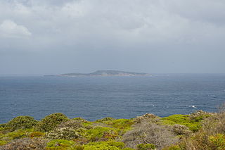
Eclipse Island is a barren island in Western Australia, 17 kilometres (10.6 mi) due south of Albany, and 6.1 km (3.8 mi) south of the nearest point of the mainland coast, which is Cave Point on the southern coast of Torndirrup Peninsula. Eclipse Island Lighthouse is located near the centre of the island. Nearby South West Island contains Western Australia's southernmost landmass.

Smoky Cape Lighthouse is a heritage-listed active lighthouse located on Smoky Cape, a headland in Arakoon east of the town of South West Rocks, Kempsey Shire, New South Wales, Australia, and within the Hat Head National Park. It directs boats towards the entrance to the Macleay River, which is located just to the north of the lighthouse.

The Point Stephens Light is a heritage-listed active lighthouse located on Point Stephens, a point on an unnamed headland at the east of Fingal Bay, 4.25 km (2.64 mi) south of the entrance of Port Stephens, New South Wales, Australia. The light serves to assist vessels entering Port Stephens. It is considered an endangered lighthouse due to remote location and old age.

Completed in 1849, the original 20-metre (66 ft) Wadjemup Lighthouse was Western Australia's first stone lighthouse and was built to provide a safer sailing passage for ships to Fremantle Port and the Swan River Colony.

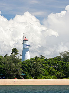
Archer Point Light is an active lighthouse on Archer Point, a conical, 60-metre-high (200 ft) grassy headland about 14 kilometres (8.7 mi) southeast of Cooktown, Queensland, Australia. Originally an 1883 timber frame lighthouse covered with galvanised iron, it was replaced in 1975 with a modern square concrete equipment room topped with a lantern.

Booby Island Light is an active heritage-listed lighthouse located on Booby Island in the Shire of Torres, near the tip of Cape York Peninsula, west of Prince of Wales Island, within the Endeavour Strait, Queensland, Australia. It marks the western entrance to the navigation channel through the Torres Strait. It was the last of the major lights to be constructed along the Queensland coast.

Sandy Cape Light is a heritage-listed active lighthouse located on Sandy Cape, the most northern point on K'gari, Queensland, Australia. It stands about 6 kilometres (3.7 mi) southwest of the northeastern tip of the island. It is the tallest lighthouse in Queensland. Built in 1870, it is the second major lighthouse to be built in Queensland after its formation in 1859. It is one of the first lighthouses in Australia to be constructed using bolted prefabricated segments of cast iron, and one of only two such lighthouses in Queensland, the other being its sibling, Bustard Head Light.

Old Caloundra Light, also known as Old Caloundra Head Light or Cape Caloundra Light, is an inactive lighthouse located in Caloundra on the Sunshine Coast in South East Queensland, Australia. It is the oldest surviving building in Caloundra. The lighthouse was active between 1896 and 1968. The tower was relocated twice. In 1970 it was relocated from its original location to Woorim Park in Caloundra, and in 1999 it was returned to its original site on Canberra Terrace near downtown Caloundra, where it stands today.
New Caloundra Light, also known as New Caloundra Head Light, is an inactive lighthouse located in Caloundra on the Sunshine Coast in South East Queensland, Australia. It stands on Canberra Terrace near downtown Caloundra. The lighthouse was active from 1968 to 1992. It has a unique design resembling an airport control tower, the only surviving example of a lighthouse of this design in Australia.

Cape Capricorn Light is an active heritage-listed lighthouse located on Cape Capricorn, a coastal headland on the northeast point of Curtis Island, in Gladstone Region, Central Queensland, Australia. The lighthouse, constructed in 1964, is the third at this site, following a timber frame lighthouse constructed in 1875 and a concrete lighthouse constructed around 1937. It was added to the Queensland Heritage Register on 31 August 2001.
Fitzroy Island Light is an inactive lighthouse on Fitzroy Island, a continental island 29 kilometres (18 mi) southeast of Cairns, Queensland, Australia. It was only active between 1973 and 1992 but, together with Little Fitzroy Island Light, there has been a light station in the area since 1929. Fitzroy Island lighthouse now serves as a visitor centre for the Fitzroy Island National Park.

Cape Moreton Light, also listed as North Point Range Rear Light, is a heritage-listed active lighthouse located on Cape Moreton, a rocky headland located at the north eastern tip of Moreton Island, a large sand island on the eastern side of Moreton Bay, on the coast of South East Queensland, Australia. It marks the northern entrance to Moreton Bay and Brisbane and also serves as the rear light for the North Point Range. With its two distinctive red bands, it also serves as a daymark. It is the oldest lighthouse in Queensland, and the only one to be built by the New South Wales Government before the separation of Queensland, which took place in 1859. It is also the only lighthouse in Queensland to be built of stone.
Cape Cleveland Light is an active heritage-listed lighthouse located on the northern tip of Cape Cleveland, a promontory projecting into the Coral Sea west of Cleveland Bay in the locality of Cape Cleveland about 40 kilometres (25 mi) east of Townsville, Queensland, Australia. The lighthouse marks the northern point of the Cape, and the entrance to Cleveland Bay.

Cleveland Point Light, also known as Point Cleveland Light, is a lighthouse located on the north-eastern tip of Cleveland Point, at Cleveland, Redland City, Queensland, Australia. It overlooks Moreton Bay to the east and Raby Bay to the west. The old lighthouse was established in 1864-1865 as a wooden hexagonal tower. It is one of only two surviving lighthouses of this form, the other being Old Burnett Heads Light. A newer light, constructed of a concrete post, replaced it in 1976, and the old lighthouse was relocated a short distance away, where it stands today. The newer light was removed in 2009.

Dent Island Light is an active lighthouse on Dent Island, a small island off the coast of Queensland, Australia, part of the Whitsunday Group of the Whitsunday Islands. Located on the southwest tip of the island, the light guides ships navigating the Whitsunday Passage, between Whitsunday Island and the islands to the west, and marks the Dent Island Passage.

Double Island Point Light is an active lighthouse located at the summit of Double Island Point, a coastal headland within the Cooloola section of the Great Sandy National Park. It is located at the southern end of Wide Bay, 70 kilometres (43 mi) north of Noosa Heads, Queensland, Australia.
Eborac Island Light is an active lighthouse on Eborac Island, a small rocky island in the Adolphus Channel just off Cape York, the northern tip of Cape York Peninsula, Far North Queensland, Australia. It guides ships into the coastal channel inside the Great Barrier Reef. A concrete structure was built in 1921 and converted to solar power in 1990. It was replaced with a fiberglass structure in 2012.
Low Isles Light, also known as Low Islets Light or Low Island Light, is an active lighthouse located on Low Island, a coral cay which together with Woody Island forms the Low Isles group, about 13 kilometres (8.1 mi) northeast of Port Douglas, Queensland, Australia. The island is situated on the western edge of the main shipping channel into the harbour of Port Douglas, and it marks the entrance to the channel. Built in 1878, it was the first lighthouse in Far North Queensland and more specifically the first to light the Inner Passage of the Great Barrier Reef. Its construction is typical to Queensland lighthouses of the time, timber frame clad with galvanized iron, and it is the fourth lighthouse of this type constructed in Queensland, though it is the first of them to use portholes.

Wyborn Reef Light is an active lighthouse located at Wyborn Reef, formerly known as Y Reef, about 16 kilometres (9.9 mi) southeast of Albany Island, east of the tip of Cape York Peninsula, Queensland, Australia. It marks the entrance to the Albany Passage. The lighthouse was constructed in 1938 and upgraded in 1991 and 1995. The structure is a stainless steel tower with a fiberglass hut within the framework, carrying a lantern.

