
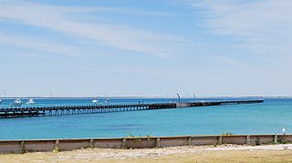
Cape Jaffa is a headland in the Australian state of South Australia located at the south end of Lacepede Bay on the state's south east coast about 20 kilometres south west of the town centre of Kingston SE. The cape is described as being "a low sandy point" with "its sea face is about One nautical mile (1.9 km) long" and having a "wooded range rises near the S[outh] part of the cape and reaches a height of 77 metres at Mount Benson, about 8.5 nautical miles S[outh] E[ast]". A settlement known as King's Camp in some sources and as Cape Jaffa in other sources is located about 0.5 nautical miles to the north west of the cape. This settlement includes a jetty fitted with a navigation aid and a marina. The southern coastline of the cape forms part of the Bernouilli Conservation Reserve.

Nepean Bay is a bay located on the north-east coast of Kangaroo Island in the Australian state of South Australia about 130 kilometres south-south-west of Adelaide. It was named by the British navigator, Matthew Flinders, after Sir Evan Nepean on 21 March 1802.

Point Marsden is a headland located on the north coast of Kangaroo Island in South Australia. It was named after William Marsden, Second Secretary to the Admiralty by Matthew Flinders in 1802. It is the western extremity of Nepean Bay and has been the site of a navigation aid since 1915.
Troubridge Point is a headland in the Australian state of South Australia located on the south coast of Yorke Peninsula about 11 kilometres south west of Edithburgh. It is the western end of the opening to Gulf St Vincent.
Rivoli Bay, is a bay located on the south-east coast of the Australian state of South Australia about 311 kilometres south-southeast of the state capital of Adelaide and about 65 kilometres northwest by west of the regional centre of Mount Gambier. It was named in 1802 by the Baudin expedition of 1800-03 after André Masséna, the Duke of Rivoli and Marshal of France. It is one of four 'historic bays' located on the South Australian coast.
Lacepede Bay is a bay in the Australian state of South Australia located on the state's south-east coast about 140 kilometres northwest of Mount Gambier and about 240 kilometres southeast of Adelaide. It was named in 1802 by the Baudin expedition of 1800-03 after Bernard Germain de Lacépède, the French naturalist. It is one of four ‘historic bays’ located on the South Australian coast.

Penguin Island is an island in the Australian state of South Australia located in Rivoli Bay on the state's south east coast of approximately 1.5 kilometres south of Beachport. From 1878 to 1960, it was the site of an operating lighthouse. Since at least 1972, it has been part of the Penguin Island Conservation Park.
Guichen Bay, is a bay located on the south-east coast of the Australian state of South Australia about 115 kilometres northwest of the regional city of Mount Gambier and about 270 kilometres south-southeast of the state capital of Adelaide. It was named in 1802 by the Baudin expedition of 1800-03 after Luc Urbain de Bouëxic, comte de Guichen. The town of Robe is located at the southern end of the bay.

Pondalowie Bay is a bay in the Australian state of South Australia located on the west coast of the south-west tip of Yorke Peninsula in Spencer Gulf about 12 kilometres west of Marion Bay. The coastline of Pondalowie Bay is both within the gazetted locality of Inneston and the Innes National Park.

Aldinga Bay is a bay located on the east coast of Gulf St Vincent in South Australia about 40 kilometres south-southwest of Adelaide city centre.

Cape Banks is a headland in the Australian state of South Australia located in the gazetted locality of Carpenter Rocks at the south end of Bucks Bay and the north end of Bungaloo Bay on the state's south east coast about 36 kilometres west south west of the city of Mount Gambier.
Cape Donington is a headland in the Australian state of South Australia located at the most northerly part of the Jussieu Peninsula on the east coast of Eyre Peninsula in about 10 kilometres east of the city of Port Lincoln.
Warburto Point is a headland located on the west coast of the Yorke Peninsula in South Australia about 12 kilometres south west of the town of Wallaroo. The point is described by one source as being ‘a rocky projection that extends about 1.5 nautical miles W(est) from the mainland’ and that ‘it is 6.1 metres high and is fringed by mangroves along each of its sides.’ The land at the tip of the point has been part of the Bird Islands Conservation Park since 1972. Since 1995, it has been the site of a navigation aid in the form of a light tower which was commissioned to replace the lighthouse on Tiparra Reef. It is also the site of a coastal weather station operated by the Australian Bureau of Meteorology.
Cape Northumberland is a headland in the southeast of the Australian state of South Australia. It is the southernmost point of South Australia. It is located about 3 kilometres (1.9 mi) from the town of Port MacDonnell, 28 kilometres south southwest from the municipal seat of Mount Gambier and about 393 kilometres (244 mi) southeast of the state's capital Adelaide.

Corny Point is a headland located on the west coast of the Yorke Peninsula in South Australia about 37 kilometres north west of the town of Warooka. The point is described as being "a sloping rocky double projection..." where the "coast on the N[orth] side is low and sandy whereas the coast on the S[outh] side is higher than the point itself." It is the south headland of Hardwicke Bay. It was named by Matthew Flinders on 18 March 1802. The waters adjoining its shoreline are within the Southern Spencer Gulf Marine Park. Since 1882, it has been the site of a navigation aid in the form of a lighthouse.
Cape St Albans is a headland in the Australian state of South Australia located on the north coast of the Dudley Peninsula on Kangaroo Island in the gazetted locality of Willoughby about 18 kilometres south-east of the town of Penneshaw.

Cape Jervis is a headland located at the most westerly part of the Fleurieu Peninsula on the east coast of Gulf St Vincent in South Australia about 0.7 kilometres west of the town of the same name, Cape Jervis. It is the eastern end of the opening to Gulf St Vincent.
Cape Finniss is a headland located at the southern extremity of Anxious Bay on the west coast of Eyre Peninsula in South Australia about 6 kilometres Northwest by west of the town of Elliston. It is described as being ‘a rocky headland with a rounded top, 47 metres high.’ Cape Finniss is linked by a submerged reef which is considered to be ‘remnants of a once more prominent Cape Finnis(s)’ to the Waldegrave Islands which are located to the cape's north west.
Point Weyland is a headland located on the west coast of Eyre Peninsula in South Australia about 4 kilometres west south-west of the town of Venus Bay and about 51 kilometres north north-west of the town of Elliston. The point which is located within Anxious Bay is the southern extremity of the opening to Venus Bay. The point is described by one source as being "a conspicuous cliffy point, 89 m (292 ft) high, stands close S[outh] W[est] of the entrance of Venus Bay" and "rises to a height of 96 m (315 ft), close N[orth] and slopes inland toward Venus Bay". It was named by Matthew Flinders on 10 February 1802. The point has been within the boundary of the Venus Bay Conservation Park since 1977 while the waters adjoining its shoreline have been within a habitat protection zone in the West Coast Bays Marine Park since 2012.

Margaret Brock Reef is a reef in the Australian state of South Australia located in the state's coastal waters on its south-east coast about 7 kilometres (4.3 mi) west of the headland of Cape Jaffa and about 27.2 kilometres (16.9 mi) south-west of the town of Kingston SE. It is the site of both a navigation aid which operated as a manned lighthouse from 1872 to 1973 and as an automatic beacon onward to the present day, and a rock lobster sanctuary declared under state law in 1973. It is named after the barque Margaret Brock which was wrecked there in 1852.

