The Centaur Memorial remembers the sinking of Australian Hospital Ship Centaur by a Japanese submarine on 14 May 1943. The Walk of Remembrance commemorates other ships lost to Japanese and German action during World War II and takes the form of plaques arranged in a semicircle around the lookout fence.
History
Captain James Cook, upon encountering the eastern Australian coast and naming Ram Head, today's Rame Head (Victoria), then sailed up the coast to the famous Botany Bay. Continuing North from there, at about 5 pm on 16 May 1770 (log date) he encountered the reefs that run 3 nautical miles (5.6km; 3.5mi) east from Fingal Head and Cook Island. To avoid these reefs, formed by a lava flow from Mount Warning, Cook was forced to change his course to the east. Cook's log indicates his ship was "about 5 miles from the land". However having to pull away to the east to avoid the reefs, that we now know only run 3 nautical miles (5.6km; 3.5mi) to sea from Cook Island, would indicate Cook was much closer to Fingal Head the point he named Point Danger.[1]
The next morning, (same log date 16 May) James Cook, although much further out to sea, recorded the location of the reefs and named the point off which the island and reefs lie - Point Danger. He wrote:
We now saw the breakers again they lay two Leagues from a point under which is a small Island, their situation may always be found by the peaked mountain before mentioned from them this mountain or hill, and on this account I have named Mount Warning it lies 7 or 8 Leagues inland the land is high and hilly about it, but it is conspicuous enough to be distinguished from everything else. The point off which these shoals lay I have named Point Danger.[2]
These reefs are now named Danger Reefs and comprise Inner Reef, South Reef and Outer Reef.[3]
There has been controversy over the naming of Point Danger for many years. It seems the controversy began as early as 1823, when government surveyor, John Oxley, set out in HMCS Mermaid to explore Port Curtis, the site of Gladstone. Oxley explored Moreton Bay, which had been named by Captain Cook, and the Brisbane River, as well as exploring and naming the Tweed River. It was during this voyage that Oxley encountered what is now known as Fingal Head and reported it as being Point Danger, so named by Captain James Cook.[4][5][6] Oxley's favourable report on the Brisbane River saw him return the following year and establish the colony of Brisbane under the direction of Sir Thomas Brisbane, Governor of New South Wales in 1824.
At some time in 1828 Henry John Rous, travelling north, charted the Tweed River, which he named the Clarence River, unaware that it had already been named the Tweed River by Oxley in 1823.[7] Rous came up the eastern coastline and around the reef off the coast of the feature now known Fingal Head, and arrived at a place now called Rainbow Bay, so named after his ship. It was there that Henry Rous has arguably caused all of the confusion. He named the, at the time, unnamed site of Point Danger as being that of Cook's Point Danger.
There was further confusion as to the location of Cook's Point Danger when in 1840 surveyor Robert Dixon was given the task of doing the first land survey of the area. Dixon's role was to map the New South Wales and Queensland border. He was told to map the border from the west to Point Danger on the east coast. Dixon took the location of Cook's Point Danger as being that of the one identified by Rous in 1828 rather than the one identified by Oxley in 1823.
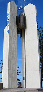
In 1970, on the 200th anniversary of Cook's naming of Point Danger and given that the location seemed to be correct, a memorial was placed at the current site and the New South Wales, Queensland and Federal governments combined to erect the Point Danger Captain Cook Memorial Lighthouse. However, in 1971, the following year, after much debate about the location of Cook's Point Danger and the Queensland-New South Wales border, the Geographical Names Board declared:
little doubt exists that the feature named Point Danger by Captain Cook was in actual fact the feature now known as Fingal Head. However, as the name has been known in its present position for over 130 years and having in mind the wording of the letters Patent of 6 June 1859, in which the position of the QLD-New South Wales border is linked with the position of Point Danger, the Board is not prepared to assign the name to any feature or position other than that to which it is currently located.[8]
The misnaming obviously raised a significant constitutional issue. Yet despite this pronouncement, some 18 years later debate was still continuing. In November 1989 the Geographical Names Board approved a historical re-enactment of Cook's voyage. The research for the re-enactment led to Acting Chief Surveyor Ron Benjamin finding that:
From the re-enactment voyage, I now have no doubt that Captain Cook's, 'point of land under which lies a small island', was intended to be today's Fingal Head.[9]
However, in 1998, following another review, the New South Wales Geographic Names Board, it was concluded, in part:
From an analysis of Cook’s Private Log, the Official Log of the 'Endeavour', Cook’s Journal and the journals of Cook’s Officers, and relating the analysis to modern nautical charts and maps of the area, it is suggested that the following conclusions be drawn:
5. It is the opinion of the Geographic Names Board Committee therefore that the present Point Danger is correctly designated.[10]
The matter did not finish there however. Many were unhappy with a conclusion that appeared to be so at odds with the historical facts and agitation continued. Trevor Lipscombe, in closely tracking Cook's voyage and ground-truthing the places he named, concluded in On Austral Shores (2005), that:
There can be little doubt that Fingal Head is Cook’s Point Danger[11]
In 2007, at Ken Gold's behest, Dr Nigel Erskine of the Australian National Maritime Museum reviewed the argument put forward by the Geographic Names Board.[12] As a result of Gold's representations, and support from a number of authorities, Mr Chris Hartcher was able to rise and inform the Parliament of New South Wales on 9 April 2008:
that today the Geographical Names Board has considered Mr Gold's efforts and announced that the official records for Point Danger and Fingal Head will be changed to reflect both the historical versions of the naming of Cook's Point Danger.[13][14]
The lighthouse/Cook Memorial was finished in 1971. It is an unusual modern style lighthouse and was the first in the world to experiment with lasers to increase its beam. The experiment was unsuccessful and it returned to conventional electric lamps. It emits a double white flash every ten seconds at a focal plane height of 44.5 metres. However, there are no reefs off, or running East from this point.[15] The light is operated by NSW Maritime.[16]
Related Research Articles
John Joseph William Molesworth Oxley was an explorer and surveyor of Australia in the early period of British colonisation. He served as Surveyor General of New South Wales and is perhaps best known for his two expeditions into the interior of New South Wales and his exploration of the Tweed River and the Brisbane River in what is now the state of Queensland.
Cape Byron is the easternmost point of the mainland of Australia, located in New South Wales. It is about 3 km (1.9 mi) east of the town of Byron Bay, New South Wales and projects into the Pacific Ocean at 28.6335° S, 153.6383° E. A lighthouse is situated there. It is a popular area for hiking and for whale watching. Two national parks, one a conservation area and a marine park, are on the bay.
The Tweed River is a river situated in the Northern Rivers district of New South Wales, Australia. From the middle reaches of its course, the state boundary between New South Wales and Queensland is located approximately 10 kilometres (6.2 mi) north.
Tweed Heads is a town in New South Wales. It is located on the Tweed River in north-eastern New South Wales, Australia, in Tweed Shire, next to the border with Queensland and adjacent to its "twin town" of Coolangatta, which is a suburb of the Gold Coast. It is often referred to as a town where people can change time zones – even celebrate New Year twice within an hour – simply by crossing the street, due to its proximity to the Queensland border, and the fact that New South Wales observes daylight saving whereas Queensland does not.
Mount Warning, a mountain in the Tweed Range in the Northern Rivers region of New South Wales, Australia, was formed from a volcanic plug of the now-gone Tweed Volcano. The mountain is located 14 kilometres (9 mi) west-south-west of Murwillumbah, near the border between New South Wales and Queensland. Lieutenant James Cook saw the mountain from the sea and named it Mount Warning.
Coolangatta is a coastal suburb in the City of Gold Coast, Queensland, Australia. It is the Gold Coast's southernmost suburb and it borders New South Wales. In the 2016 census, Coolangatta had a population of 5,948 people.
The Richmond River is a river situated in the Northern Rivers region of New South Wales, Australia.
Tweed Shire is a local government area located in the Northern Rivers region of New South Wales, Australia. It is adjacent to the border with Queensland, where that meets the Tasman Sea. Administered from the town of Murwillumbah, Tweed Shire covers an area of 1,321 square kilometres (510 sq mi), and has existed as a local government entity since 1947. It was named for the Tweed River.
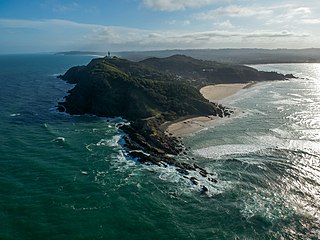
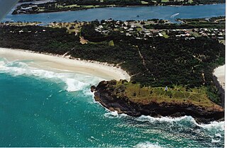
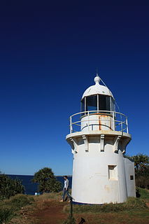
Fingal Head is a village on the Tasman Sea coast in the far northeast of New South Wales, Australia, about 5 km south of the New South Wales and Queensland border. The village is often just called Fingal. The headland and the small off-shore Island were first sighted by James Cook about 17:00 on 16 May 1770. At the time of the 2016 census, Fingal Head had a population of 592 people.
Fingal Bay is the easternmost suburb of the Port Stephens local government area in the Hunter Region of New South Wales, Australia. The only population centre is the township of the same name, which itself is named after the adjacent, small, semi-circular bay. At the 2021 census, the population of the town was 1,635.
Point Hicks, is a coastal headland in the East Gippsland region of Victoria, Australia, located within the Croajingolong National Park. The point is marked by the Point Hicks Lighthouse that faces the Tasman Sea.
Tacking Point Lighthouse is Australia's thirteenth oldest lighthouse. It was built on a rocky headland about 8 kilometres south of Port Macquarie in 1879 by Shepherd and Joseph William Mortley, to a design by the New South Wales Colonial Architect, James Barnet. It is operated by the Australian Maritime Safety Authority and is classified by the National Trust of Australia (NSW).
Oxley River, a perennial river of the Tweed River catchment, is located in the Northern Rivers region of New South Wales, Australia.
Rous River, a perennial river of the Tweed River catchment, is located in the Northern Rivers region of New South Wales, Australia.
The Tweed Range is a mountain range which is the western extension of the Tweed Volcano caldera rim, part of the Scenic Rim of the Great Dividing Range, located in northern New South Wales, near the southeastern border of Queensland, in Australia.
Fingal Head Light is an active lighthouse located at Fingal Head, New South Wales, Australia, a headland about 5 kilometres (3.1 mi) south of Point Danger, which marks the Queensland border.
Point Danger Light, also known as the Captain Cook Memorial Light, is an active lighthouse located on Point Danger, a headland between Coolangatta and Tweed Heads, marking the border between Queensland and New South Wales, Australia. It lays claim to be the first lighthouse in the world to experiment with laser as a light source.
Campbell Hill is a mountain located in Piggabeen, New South Wales (NSW), Australia. It is located in the region of the Tweed Shire in the state of New South Wales, in the eastern part of the country, 900 kilometres (560 mi) north of the capital, Canberra, approximately 107 kilometres (66 mi) from Brisbane and 24 kilometres (15 mi) from Surfers Paradise. Campbell Hill is approximately 123 metres (404 ft) above sea level. Piggabeen is situated in the hinterland approximately 5 km behind the Gold Coast Highway and the Gold Coast International and Domestic Airport. Piggabeen and its valley adjoins Currumbin Valley in Queensland.
Cook Island, formerly Cooks Island, Turtle Island and Joong-urra-narrian, is an island in the Australian state of New South Wales located on the state's north coast about 600 metres (2,000 ft) north-east of Fingal Head and 4 kilometres (2.5 mi) south-east of the town of Tweed Heads.
George Poynter Heath was a Royal Navy captain and the first portmaster of Queensland, Australia. It was under his supervision and administration that the 2,086 miles (3,357 km) of coast of Queensland, and its numerous river and creeks, were marked for navigation purposes by means of buoys, beacons, and lights.
This page is based on this Wikipedia article Text is available under the CC BY-SA 4.0 license; additional terms may apply. Images, videos and audio are available under their respective licenses.