
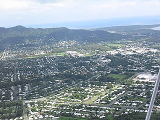
Cairns is a city in the Cairns Region, Queensland, Australia. It is on the east coast of Far North Queensland. The city is the 5th-most-populous in Queensland and ranks 14th overall in Australia.

Yarrabah, traditionally Yagaljida in the Yidin language spoken by the indigenous Yidinji people, is a coastal town and locality in the Aboriginal Shire of Yarrabah, Queensland, Australia. It is an Aboriginal community about 53 kilometres (33 mi) by road from Cairns CBD on Cape Grafton. It is much closer by direct-line distance but is separated from Cairns CBD by the Murray Prior Range and Trinity Inlet, an inlet of the Coral Sea. At the 2016 census, Yarrabah had a population of 2,559.
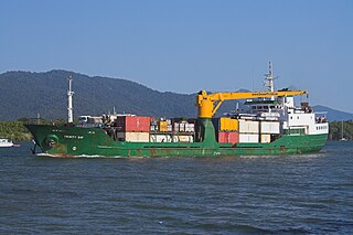
The Trinity Inlet is an oceanic inlet which serves as the port for the city of Cairns, Queensland, Australia. The city centre is on the western bank where the inlet meets the Coral Sea.

Kuranda is a town and locality on the Atherton Tableland in the Shire of Mareeba, Far North Queensland, Australia. The town of Myola is also located within the locality of Kuranda. It is 25 kilometres (16 mi) from Cairns, via the Kuranda Range road. It is surrounded by tropical rainforest and adjacent to the Wet Tropics World Heritage listed Barron Gorge National Park. It is within the local government area of Shire of Mareeba. In the 2016 census, Kuranda had a population of 3,008 people.
Herberton is a rural town and locality in the Tablelands Region, Queensland, Australia. In the 2016 census, Herberton had a population of 855 people.

The Barron River is located on the Atherton Tablelands inland from Cairns in northern Queensland, Australia. With its headwaters below Mount Hypipamee, the 165-kilometre (103 mi)-long river with a catchment area of approximately 2,138 square kilometres (825 sq mi) forms through run off from the Mount Hypipamee National Park, flows through Lake Tinaroo, and eventually empties into the Coral Sea near Smithfield.

Far North Queensland, which is often known simply as FNQ, is the northernmost part of the Australian state of Queensland. Its largest city is Cairns and it is dominated geographically by Cape York Peninsula, which stretches north to the Torres Strait, and west to the Gulf Country. The waters of Torres Strait include the only international border in the area contiguous with the Australian mainland, between Australia and Papua New Guinea.
The history of Cairns in Queensland, Australia, is a transition of a port from a shanty town to a modern city, following an uncertain start because of competition from the newly created neighbouring community of Port Douglas. A succession of major work projects, institution establishments and direct involvement in world enterprise accelerated the settlement's development.

Smithfield is a suburb of Cairns in the Cairns Region, Queensland, Australia. At the 2016 census the suburb recorded a population of 5,303.

Wallaville is a rural town and locality in the Bundaberg Region, Queensland, Australia. It is 372 kilometres (231 mi) north of the state capital, Brisbane and 43 kilometres (27 mi) south west of the regional centre of Bundaberg. In the 2016 census, Wallaville had a population of 410 people.

Cape Grafton is a cape located to the north-east of Cairns in Queensland, Australia. The cape was named by Lieutenant James Cook during his first voyage of discovery in 1770. It was named after Augustus FitzRoy, 3rd Duke of Grafton, the British prime minister when Cook sailed. Cook set anchor two miles from the shore and briefly inspected the cape with botanists Joseph Banks and Daniel Solander.

The Mulgrave River, incorporating the East Mulgrave River and the West Mulgrave River, is a river system located in Far North Queensland, Australia. The 70-kilometre (43 mi)-long river flows towards the Coral Sea and is located approximately 50 kilometres (31 mi) south of Cairns.

The geography of Queensland in the north-east of Australia, is varied. It includes tropical islands, sandy beaches, flat river plains that flood after monsoon rains, tracts of rough, elevated terrain, dry deserts, rich agricultural belts and densely populated urban areas.

Trinity Beach is a coastal suburb of Cairns in the Cairns Region, Queensland, Australia. At the 2016 census, Trinity Beach had a population of 5,488.

Kewarra Beach is a coastal suburb of Cairns in the Cairns Region, Queensland, Australia. At the 2016 Australian Census the suburb recorded a population of 5,652.
White Rock is a suburb of Cairns in the Cairns Region, Queensland, Australia.

Lower Tully is a locality in the Cassowary Coast Region, Queensland, Australia.
Manunda is a suburb of Cairns in the Cairns Region, Queensland, Australia. In 2016 census, the population of Manunda was 5,390.
Trinity Park is a coastal suburb of Cairns in the Cairns Region, Queensland, Australia. In the 2016 census, the population of Trinity Park was 3,105.

