Keppel Bay

Last updated

Map all coordinates using: OpenStreetMap
Keppel Bay
Rosslyn Bay Harbour.jpg
Boats anchored at Rosslyn Bay Harbour, on Keppel Bay
Australia Queensland relief location map.jpg
Red pog.svg
Keppel Bay
Location Central Queensland
Coordinates 23°23′20″S150°53′53″E / 23.389°S 150.898°E / -23.389; 150.898 (Keppel Bay) [1]
River sources Fitzroy River
Ocean/sea sources Coral Sea
Basin  countries Australia

Keppel Bay is a bay in Central Queensland, Australia, at the mouth of the Fitzroy River on the coast of the Coral Sea.

Contents

Extent

Keppel Bay extends from Station Point on Curtis Island ( 23°27′00″S151°01′00″E / 23.4500°S 151.0167°E / -23.4500; 151.0167 (Station Point) ) in the Gladstone Region to Zilzie Point at Zilzie ( 23°16′47″S150°49′29″E / 23.2797°S 150.8247°E / -23.2797; 150.8247 (Zilzie Point) ) in the Shire of Livingstone. [2] [1] [3] [4]

Islands

The named islands in Keppel Bay from north to south are: [5]

Despite the name, the islands in Keppel Bay Islands National Park are not within Keppel Bay but are to the north and east of the bay. [5]

History

Keppel Bay was named by Captain Cook when he was there on 27 May 1770, after Admiral Augustus Keppel of the British Royal Navy. [1] [15]

View

Keppel Bay & Curtis Island Annotatedsmallcurtisjpg.jpeg
Keppel Bay & Curtis Island

See also

Related Research Articles

<span class="mw-page-title-main">Yeppoon</span> Town in Queensland, Australia

Yeppoon is a coastal town and locality in the Shire of Livingstone, Queensland, Australia. Yeppoon is renowned for its beaches, tropical climate, and the islands out on the bay. Located 41 kilometres (25 mi) from the city of Rockhampton, Yeppoon is the seat of the Shire of Livingstone and the principal town on the Capricorn Coast, a string of seaside communities stretching more than 150 kilometres (93 mi) from north to south. The beaches and shallow coves provide a destination both for tourists and retirees settling down in Central Queensland. Offshore, there are 27 islands including Great Keppel Island which is 20 kilometres (12 mi) from Yeppoon. In the 2021 census, the locality of Yeppoon had a population of 7,037 people; this does not include any neighbouring suburbs.

<span class="mw-page-title-main">Capricorn Coast</span> Region in Queensland, Australia

The Capricorn Coast is a stretch of coastline in Central Queensland, Australia and is part of the Shire of Livingstone.

<span class="mw-page-title-main">Shire of Livingstone</span> Local government area in Queensland, Australia

The Shire of Livingstone is a local government area located in the Capricornia region of Central Queensland, Queensland, Australia, to the immediate north and east of the regional city of Rockhampton. The shire, administered from the coastal town of Yeppoon, covers an area of 11,758 square kilometres (4,539.8 sq mi), and existed as a local government entity from 1879 until 2008, when it amalgamated with several other councils to become the Rockhampton Region. The Shire was re-established on 1 January 2014 following a successful de-amalgamation referendum in 2013.

<span class="mw-page-title-main">Kinka Beach, Queensland</span> Suburb of Shire of Livingstone, Queensland, Australia

Kinka Beach is a coastal rural locality in the Livingstone Shire, Queensland, Australia. In the 2016 census, Kinka Beach had a population of 621 people.

<span class="mw-page-title-main">Keppel Sands, Queensland</span> Town in Queensland, Australia

Keppel Sands is a coastal rural town and locality in the Livingstone Shire, Queensland, Australia. In the 2016 census, the locality of Keppel Sands had a population of 360 people.

<span class="mw-page-title-main">Port Alma, Queensland</span> Town in Queensland, Australia

Port Alma is a coastal town, locality and port in the Rockhampton Region, Queensland, Australia. In the 2016 census, Port Alma had a population of 0 people.

<span class="mw-page-title-main">Zilzie</span> Suburb of Shire of Livingstone, Queensland, Australia

Zilzie is a coastal locality in the Livingstone Shire, Queensland, Australia. In the 2021 census, Zilzie had a population of 2,846 people.

<span class="mw-page-title-main">Cooee Bay</span> Suburb of Shire of Livingstone, Queensland, Australia

Cooee Bay is a coastal locality in the Livingstone Shire, Queensland, Australia. In the 2016 census Cooee Bay had a population of 913 people.

<span class="mw-page-title-main">Taranganba</span> Town in Queensland, Australia

Taranganba is a town and locality in the Livingstone Shire, Queensland, Australia. In the 2016 census, the locality of Taranganba had a population of 2,276 people.

<span class="mw-page-title-main">Lammermoor, Queensland</span> Suburb of Shire of Livingstone, Queensland, Australia

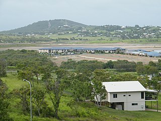
Lammermoor is a coastal locality on the Capricorn Coast in the Livingstone Shire, Queensland, Australia. In the 2016 census, Lammermoor had a population of 2,167 people.

<span class="mw-page-title-main">The Caves, Queensland</span> Town in Queensland, Australia

The Caves is a rural town and locality in the Livingstone Shire, Queensland, Australia. In the 2016 census the locality of The Caves had a population of 718 people.

<span class="mw-page-title-main">Rosslyn, Queensland</span> Town in Queensland, Australia

Rosslyn is a coastal town and locality in the Livingstone Shire, Queensland, Australia. In the 2016 census, the locality of Rosslyn had a population of 574 people.

Stanage is a coastal rural town and locality in the Livingstone Shire, Queensland, Australia. In the 2016 census, Stanage had a population of 83 people.

<span class="mw-page-title-main">Callemondah</span> Suburb of Gladstone, Queensland, Australia

Callemondah is a coastal suburb of Gladstone in the Gladstone Region, Queensland, Australia. It contains the Port of Gladstone. In the 2016 census Callemondah had a population of 18 people.

<span class="mw-page-title-main">Curtis Island, Queensland</span> Suburb of Gladstone Region, Queensland, Australia

Curtis Island is a locality in the Gladstone Region, Queensland, Australia. In the 2016 census, Curtis Island had a population of 323 people.

The Narrows is a coastal locality in the Gladstone Region, Queensland, Australia. In the 2021 census, The Narrows had a population of 0 people.

<span class="mw-page-title-main">Thompson Point, Queensland</span> Suburb of Livingstone Shire, Queensland, Australia

Thompson Point is a coastal locality in the Livingstone Shire, Queensland, Australia. It was the site of a short-lived town and port called Broadmount. In the 2021 census, Thompson Point had a population of 4 people.

<span class="mw-page-title-main">Coorooman, Queensland</span> Suburb of Livingstone Shire, Queensland, Australia

Coorooman is a rural coastal locality in the Livingstone Shire, Queensland, Australia. In the 2021 census, Coorooman had a population of 97 people.

The Keppels is a locality containing a group of islands in the Coral Sea within the Livingstone Shire, Queensland, Australia. In the 2016 census, The Keppels had a population of 50 people. The largest islands are Great Keppel Island and North Keppel Island.

<span class="mw-page-title-main">Broadmount, Queensland</span> Town in Queensland, Australia

Broadmount is an abandoned riverside town in the Livingstone Shire, Queensland, Australia. It is within the locality of Thompson Point. From 1899 to 1929 it operated as a port serving Central Queensland.

References

  1. 1 2 3 "Keppel Bay – bay in Livingstone Shire (entry 17997)". Queensland Place Names. Queensland Government . Retrieved 4 February 2021.
  2. "Bays - Queensland". Queensland Open Data. Queensland Government. 12 November 2020. Archived from the original on 25 November 2020. Retrieved 25 November 2020.
  3. "Station Point – cape in Gladstone Region (entry 32297)". Queensland Place Names. Queensland Government . Retrieved 4 February 2021.
  4. "Zilzie Point – point in Shire of Livingstone (entry 38858)". Queensland Place Names. Queensland Government . Retrieved 4 February 2021.
  5. 1 2 "Queensland Globe". State of Queensland . Retrieved 4 February 2021.
  6. "Round Rock – rock in Livingstone Shire (entry 29205)". Queensland Place Names. Queensland Government . Retrieved 27 December 2020.
  7. "Flat Rock – rock in Livingstone Shire (entry 12729)". Queensland Place Names. Queensland Government . Retrieved 27 December 2020.
  8. "Girt Island – island in Livingstone Shire (entry 13848)". Queensland Place Names. Queensland Government . Retrieved 27 December 2020.
  9. "Shelly Knob – island in Gladstone Regional (entry 30697)". Queensland Place Names. Queensland Government . Retrieved 27 December 2020.
  10. "Satellite Island – island in Rockhampton Regional (entry 29976)". Queensland Place Names. Queensland Government . Retrieved 29 December 2020.
  11. "Mackenzie Island – island in Livingstone Shire (entry 20452)". Queensland Place Names. Queensland Government . Retrieved 27 December 2020.
  12. "Egg Island – island (entry 11267)". Queensland Place Names. Queensland Government . Retrieved 25 November 2020.
  13. "Mud Island – island in Livingstone Shire (entry 23270)". Queensland Place Names. Queensland Government . Retrieved 27 December 2020.
  14. "Balaclava Island – island in Gladstone Regional (entry 1286)". Queensland Place Names. Queensland Government . Retrieved 27 December 2020.
  15. Captain Cook's Journal During the First Voyage Round the World at Project Gutenberg