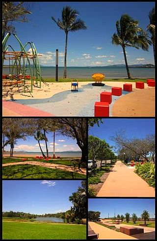
Edgecumbe Bay is a bay in the Whitsunday Region, Queensland, Australia. [1]

Edgecumbe Bay is a bay in the Whitsunday Region, Queensland, Australia. [1]

It is part of the Coral Sea. It is between the headlands of Cape Edgecumbe (at its western extent, 19°58′35″S148°15′36″E / 19.9764°S 148.2600°E ) and Cape Gloucester (at its eastern extent, 20°03′43″S148°27′13″E / 20.0619°S 148.45361°E ). [2] [3] From west to east, its coastline is with the localities of Bowen, Gregory River, and Cape Gloucester. [4]
The bay was named by Lieutenant James Cook on 4 June 1770 in honour of George Edgcumbe, 1st Earl of Mount Edgcumbe. [1] [5]

Bowen is a coastal town and locality in the Whitsunday Region, Queensland, Australia. In the 2021 census, the locality of Bowen had a population of 11,205 people.

Airlie Beach is a coastal locality and resort town in the Whitsunday Region of Queensland, Australia. In the 2021 census, Airlie Beach had a population of 1,312 people.

Shute Harbour is a coastal locality and harbour in the Whitsunday Region of Queensland, Australia. It has port facilities and transport options for people seeking to access the Whitsunday Islands and holiday destinations.

Seventeen Seventy, sometimes written 1770 or Town of 1770, is a coastal town and locality in the Gladstone Region, Queensland, Australia. In the 2021 census, the locality of Seventeen Seventy had a population of 125 people.

Proserpine is a rural town and locality in the Whitsunday Region, Queensland, Australia. In the 2021 census, the locality of Proserpine had a population of 3,614 people.

Springlands is a rural locality in the Whitsunday Region, Queensland, Australia.

Cannonvale is a coastal locality in the Whitsunday Region, Queensland, Australia. In the 2021 census, Cannonvale had a population of 6,596 people.

Midge Point is a coastal town and rural locality in the Mackay Region, Queensland, Australia. In the 2021 census, the locality of Midge Point had a population of 435 people.

Guthalungra is a rural town and coastal locality in the Whitsunday Region, Queensland, Australia. In the 2021 census, the locality of Guthalungra had a population of 112 people.

Cape Conway is a coastal locality in the Whitsunday Region, Queensland, Australia. In the 2021 census, Cape Conway had "no people or a very low population".
Mentmore is a coastal locality in the Mackay Region, Queensland, Australia. In the 2021 census, Mentmore had "no people or a very low population".
Whitsundays is an island group locality in the Whitsunday Region, Queensland, Australia. It consists of the Whitsunday Group of islands off the Queensland east coast in the Coral Sea, which is a mix of inhabited and uninhabited islands. In the 2021 census, Whitsundays had a population of 2,281 people.
Mandalay is a coastal locality in the Whitsunday Region, Queensland, Australia. In the 2021 census, Mandalay had a population of 338 people.
Woodwark is a coastal locality in the Whitsunday Region, Queensland, Australia. In the 2021 census, Woodwark had a population of 559 people.

Cape Gloucester is a coastal rural locality in the Whitsunday Region, Queensland, Australia. In the 2021 census, Cape Gloucester had a population of 85 people.

Dingo Beach is a coastal rural locality in the Whitsunday Region, Queensland, Australia. In the 2021 census, Dingo Beach had a population of 159 people.

Hideaway Bay, also spelled Hydeaway Bay, is a coastal town and locality in the Whitsunday Region, Queensland, Australia. In the 2021 census, the locality of Hideaway Bay had a population of 232 people.

Kimberley is a coastal locality in the Shire of Douglas, Queensland, Australia. In the 2021 census, Kimberley had a population of 28 people.
Gregory River is a coastal rural locality in the Whitsunday Region, Queensland, Australia. In the 2021 census, Gregory River had a population of 427 people.
Heronvale is a coastal town in the Whitsunday Region, Queensland, Australia. It is within the locality of Bowen.