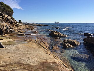
The Kamay Botany Bay National Park is a heritage-listed protected national park that is located in the Sydney metropolitan region of New South Wales, in eastern Australia. The 456-hectare (1,130-acre) national park is situated approximately 16 kilometres (9.9 mi) south-east of the Sydney central business district, on the northern and southern headlands of Botany Bay. The northern headland is at La Perouse and the southern headland is at Kurnell.

The Bundjalung National Park is a 210-square-kilometre (81 sq mi) national park located on the north coast of New South Wales, Australia, 554 kilometres (344 mi) north-east of Sydney. It protects an area of coastal plain, heathland and solitary beaches between the towns of Iluka and Evans Head.

Hat Head is a national park in New South Wales, Australia, 461.7 kilometres (286.9 mi) via M1 and Pacific Highway/A1, northeast of Sydney. It lies within the Hastings-Macleay Important Bird Area.
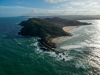
Cape Byron is the easternmost point of the mainland of Australia, located in New South Wales. It is about 3 km (1.9 mi) east of the town of Byron Bay, New South Wales and projects into the Pacific Ocean at 28.6335° S, 153.6383° E. A lighthouse is situated there. It is a popular area for hiking and for whale watching. Two national parks, one a conservation area and a marine park, are on the bay.

The sand tiger shark, grey nurse shark, spotted ragged-tooth shark or blue-nurse sand tiger, is a species of shark that inhabits subtropical and temperate waters worldwide. It inhabits the continental shelf, from sandy shorelines and submerged reefs to a depth of around 191 m (627 ft). They dwell in the waters of Japan, Australia, South Africa, the Mediterranean and the east coasts of North and South America. Despite its common names, it is not closely related to either the tiger shark Galeocerdo cuvier or the nurse shark Ginglymostoma cirratum.

The Julian Rocks Nguthungulli Nature Reserve is a protected nature reserve that is located on the Julian Rocks in the Northern Rivers region of New South Wales, in Australia. The 4,047-hectare (10,000-acre) reserve comprise two small islands, situated in the Tasman Sea of the South Pacific Ocean, approximately 2.5 kilometres (1.6 mi) northeast of Byron Bay.

South West Rocks is located on the Mid North Coast of New South Wales, Australia, near the mouth of the Macleay River. It is approximately 40 km (25 mi) from Kempsey. Jerseyville is located nearby.
Fingal Head is a village on the Tasman Sea coast in the far northeast of New South Wales, Australia, about 5 km south of the New South Wales and Queensland border. The village is often just called Fingal. The headland and the small off-shore Island were first sighted by James Cook about 17:00 on 16 May 1770. At the time of the 2016 census, Fingal Head had a population of 592 people.

Wolf Rock is a set of four volcanic pinnacles two kilometres north-northeast of Double Island Point in Cooloola, Gympie Region, Queensland, Australia. The location is a popular scuba diving spot.

Fingal Bay is the easternmost suburb of the Port Stephens local government area in the Hunter Region of New South Wales, Australia. The only population centre is the township of the same name, which itself is named after the adjacent, small, semi-circular bay. At the 2011 census, the population of the town was 1,503.
Arakoon is an eastern suburb of the town of South West Rocks in Kempsey Shire, New South Wales, Australia. At the 2016 census, Arakoon had a population of 420 people.

Bass Point is a headland in Australia on the New South Wales south coast.

One of the first shark species to be protected was the grey nurse shark. The biology, distribution and conservation of this species are dealt with in the following paragraphs with a main focus on Australia as it was here it first became protected.
Nobbys Head is a headland located on the southern entrance to Newcastle Harbour, New South Wales, Australia. The headland is situated above the Hunter River and the Tasman Sea of the South Pacific Ocean.

Tacking Point Lighthouse is Australia's thirteenth oldest lighthouse. It was built on a rocky headland about 8 kilometres south of Port Macquarie in 1879 by Shepherd and Joseph William Mortley, to a design by the New South Wales Colonial Architect, James Barnet. It is operated by the Australian Maritime Safety Authority and is classified by the National Trust of Australia (NSW).

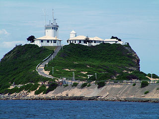
Smoky Cape Lighthouse is a heritage-listed active lighthouse located on Smoky Cape, a headland in Arakoon east of the town of South West Rocks, Kempsey Shire, New South Wales, Australia, and within the Hat Head National Park. It directs boats towards the entrance to the Macleay River, which is located just to the north of the lighthouse.

Cape Byron Light, also called Cape Byron Lightstation, is an active heritage-listed lighthouse and now interpretative centre, interpretative space, maritime museum, administration office, retail building, accommodation, tourist attraction and visitor attraction located at Lighthouse Road, Byron Bay, Cape Byron, Byron Shire, New South Wales, Australia. It was designed by Charles Harding and Cecil W. Darley and built from 1899 to 1901 by Messrs Mitchell & King. It is also known as Cape Byron Lightstation, Byron Bay Lighthouse, Cape Byron Headlan and Cape Byron Headland Reserve. The property is owned by NSW National Parks & Wildlife Service.
Cape Byron Marine Park is one of four Marine Parks in New South Wales, Australia, and is the most recently sanctioned. The Cape Byron Marine Park is located in Northern NSW and extends 37 kilometres (23 mi) from the Brunswick River to Lennox Head. The Marine Park extends out to 3 nautical miles which dictates the border between state and federal jurisdiction. The marine park covers the area of 220 square kilometres (85 sq mi) and includes a variety of marine terrain including beaches, rocky shores, open ocean and the tidal waters of the Brunswick River and its tributaries, the Belongil creek and Tallow Creek. The Cape Byron Marine Park was declared in 2002 and the zoning plan was implemented in April 2006. Of the 15 distinct marine ecosystems identified within the Tweed-Moreton bioregion, the Cape Byron Marine Park supports 10 of these.

Cape Banks is a headland in the Australian state of South Australia located in the gazetted locality of Carpenter Rocks at the south end of Bucks Bay and the north end of Bungaloo Bay on the state's south east coast about 36 kilometres west south west of the city of Mount Gambier.

Solitary Islands Marine Park (SIMP) is a marine park in New South Wales State waters, Australia. It adjoins the Solitary Islands Marine Reserve and was declared under the Marine Parks Act 1997 (NSW) in January 1998. Prior to this it was declared a marine reserve in 1991. The Park was one of the first declared in NSW and stretches along the northern NSW coast, from Muttonbird Island, Coffs Harbour, to Plover Island near Sandon River, 75 kilometres to the north. It includes coastal estuaries and lakes and extends from the mean high water mark, to three nautical miles out to sea, covering an area of around 72 000 hectares. There are five main islands in the Park, North Solitary Island, North West Solitary Island, South West Solitary Island, South Solitary Island and Split Solitary Island, as well as other significant outcrops such as Muttonbird Island and submerged reefs.


