Related Research Articles

Cape Hillsborough is a national park in Mackay Region, Queensland, Australia.

Hope Islands National Park is a national park in Queensland (Australia) 1,521 km north-west of Brisbane. The park consists of four islands: East Hope and West Hope, Snapper Island and Struck Island.

Cape York Peninsula is a peninsula located in Far North Queensland, Australia. It is the largest wilderness in northern Australia. The land is mostly flat and about half of the area is used for grazing cattle. The relatively undisturbed eucalyptus-wooded savannahs, tropical rainforests and other types of habitat are now recognised and preserved for their global environmental significance. Although much of the peninsula remains pristine, with a diverse repertoire of endemic flora and fauna, some of its wildlife may be threatened by industry and overgrazing as well as introduced species and weeds.
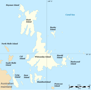
The Whitsunday Islands are 74 continental islands of various sizes off the central coast of Queensland, Australia, 900 kilometres north of Brisbane. The northernmost of the islands are off the coast by the town of Bowen, while the southernmost islands are off the coast by Proserpine. The island group is centred on Whitsunday Island, while the commercial centre is Hamilton Island. The traditional owners of the area are the Ngaro people and the Gia people, whose Juru people has the only legally recognised native title in the Whitsunday Region.

Shoalwater Bay is a large bay on the Capricorn Coast of Central Queensland, Australia 100 km north of the coastal town of Yeppoon and 628 km north-north-west of the state capital, Brisbane. Since 1966, the land surrounding Shoalwater Bay has been under the ownership of the Australian Defence Force, for the purpose of military training exercises. Shoalwater Bay is also a noted dugong habitat and is part of the Great Barrier Reef Marine Park. The bay is bounded by the Torilla Peninsula to the west and the Warginburra Peninsula and Leicester and Townshend islands to the east.
The Northumberland Islands are a scattered island chain off the eastern coast of Queensland, Australia.
Somerset is a coastal locality split between the Shire of Torres and the Northern Peninsula Area Region, Queensland, Australia. In the 2021 census, Somerset had a population of 0 people.
Halifax Bay is a region located around a bay in the Coral Sea, situated on the Australian coast in North Queensland. It is bordered by the town of Ingham to the north, city of Townsville to the south and Great Palm Island off the coast to the east.

Cape Capricorn is a coastal headland on Curtis Island, Gladstone Region, Queensland, Australia.

Keppel Bay is a bay in Central Queensland, Australia, at the mouth of the Fitzroy River on the coast of the Coral Sea.

Indian Head is a coastal headland on the eastern (ocean) side of Fraser Island off the coast of Queensland, Australia.

Willem Janszoon captained the first recorded European landing on the Australian continent in 1606, sailing from Bantam, Java, in the Duyfken. As an employee of the Dutch East India Company, Janszoon had been instructed to explore the coast of New Guinea in search of economic opportunities. He had originally arrived in the Dutch East Indies from the Netherlands in 1598, and became an officer of the VOC on its establishment in 1602.

Cooktown is a coastal town and locality in the Shire of Cook, Queensland, Australia. Cooktown is at the mouth of the Endeavour River, on Cape York Peninsula in Far North Queensland where James Cook beached his ship, the Endeavour, for repairs in 1770. Both the town and Mount Cook which rises up behind the town were named after James Cook.
The Worcester Range is a high coastal range, about 30 nautical miles long, in Antarctica. It stands between Skelton Glacier and Mulock Glacier on the western side of the Ross Ice Shelf. It is southwest of the Royal Society Range and north of the Conway Range of the Cook Mountains.
McMahon Glacier is a glacier about 18 nautical miles long in the Anare Mountains of Victoria Land, Antarctica. It drains north between the Buskirk Bluffs and Gregory Bluffs into Nielsen Fjord.

Cape Cleveland is a rural locality in the City of Townsville, Queensland, Australia. In the 2016 census Cape Cleveland had a population of 155 people.

Iron Range is a coastal locality in the Shire of Cook, Queensland, Australia. The town of Portland Road is on a north-east headland in the locality. In the 2021 census, Iron Range had a population of 30 people.

Curtis Island is a locality in the Gladstone Region, Queensland, Australia. In the 2016 census, Curtis Island had a population of 323 people.

George Poynter Heath was a Royal Navy captain and the first portmaster of Queensland, Australia. It was under his supervision and administration that the 2,086 miles (3,357 km) of coast of Queensland, and its numerous river and creeks, were marked for navigation purposes by means of buoys, beacons, and lights.
References
- ↑ "Cape Manifold". Gazetteer of Australia online. Geoscience Australia, Australian Government.
- ↑

| | This Queensland location article is a stub. You can help Wikipedia by expanding it. |