
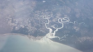
Bowling Green Bay is a national park in the City of Townsville and Shire of Burdekin, Queensland, Australia, 1,103 km northwest of Brisbane, and 28 km south of Townsville and 59 km north of Ayr. It is a Ramsar Convention listed site. The park protects diverse range of habitats including the rugged, forested landscape surrounding Mount Elliot and Saddle Mountain as well as coastal estuaries between Cape Cleveland and Cape Bowling Green.

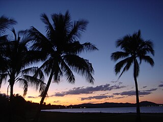
Townsville is a city on the north-eastern coast of Queensland, Australia. With a population of 179,011 as of the 2021 census, it is the largest settlement in North Queensland and Northern Australia. It is unofficially considered the capital of North Queensland. Townsville hosts a significant number of governmental, community and major business administrative offices for the northern half of the state.

Magnetic Island is an island 8 kilometres (5 mi) offshore from the city of Townsville, Queensland, Australia. This 52 km2 (20.1 sq mi) mountainous island in Cleveland Bay has effectively become a suburb of Townsville. The island is accessible from Townsville Breakwater to Nelly Bay Harbour by ferry. There is a large 39.5 km2 (15.3 sq mi) National Park and bird sanctuary and walking tracks can be taken between the populated bays and to a number of tourist destinations such as the World War II forts.

The Townsville Bulletin is a daily newspaper published in Townsville, Queensland, Australia, formerly known as the Townsville Daily Bulletin. It is the only daily paper that serves the northern Queensland region. The paper has a print edition, a subscription digital edition and a website.

North Queensland or the Northern Region is the northern part of the Australian state of Queensland that lies just south of Far North Queensland. Queensland is a massive state, larger than many countries, and its tropical northern part has been historically remote and undeveloped, resulting in a distinctive regional character and identity.
Halifax Bay is a region located around a bay in the Coral Sea, situated on the Australian coast in North Queensland. It is bordered by the town of Ingham to the north, city of Townsville to the south and Great Palm Island off the coast to the east.

Broad Sound is a large bay on the east coast of Australia, in the state of Queensland, 675 kilometers northwest of the state capital, Brisbane. It is about 50 kilometers long and 20 kilometers across at its widest point. The Torilla Peninsula forms the eastern side of the bay; Shoalwater Bay is on the other side of the peninsula. The sound has a large tidal range of about 10 metres (33 ft). This is the largest variance on the eastern Australia coastline.
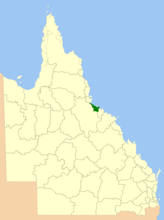
The City of Townsville is a local government area (LGA) located in North Queensland, Australia. It encompasses the city of Townsville, together with the surrounding rural areas, to the south are the communities of Alligator Creek, Woodstock and Reid River, and to the north are Northern Beaches and Paluma, and also included is Magnetic Island. In June 2018 the area had a population of 194,072, and is the 28th-largest LGA in Australia. Townsville is considered to be the unofficial capital of North Queensland.
Rowes Bay is a suburb of Townsville in the City of Townsville, Queensland, Australia. In the 2021 census, Rowes Bay had a population of 541 people.

Idalia is a southern suburb in the City of Townsville, Queensland, Australia. In the 2021 census, Idalia had a population of 4,563 people.
The Ross River Meatworks Chimney is a heritage-listed abattoir at Stuart Drive, Idalia, City of Townsville, Queensland, Australia. It is the 11th tallest structure in Townsville. It was built as part of the Ross River Meatworks in 1891 William McCallum Park and is now a major landmark as part of Fairfield Waters and part of Lancinis Springbank urban village. It was listed on the Queensland Heritage Register on 14 August 2009.

The Bohle River is a river in North Queensland, Australia.

Cape Cleveland Light is an active heritage-listed lighthouse located on the northern tip of Cape Cleveland, a promontory projecting into the Coral Sea west of Cleveland Bay in the locality of Cape Cleveland about 40 kilometres (25 mi) east of Townsville, Queensland, Australia. The lighthouse marks the northern point of the Cape, and the entrance to Cleveland Bay.

Nome is a rural locality in the City of Townsville, Queensland, Australia. In the 2021 census, Nome had a population of 990 people.

Boiling down was the term used in Australia for the process of rendering the fat from animal carcasses to produce tallow. It was a common activity on farms and pastoral properties to produce tallow to be made into soap and candles for domestic use.

Cape Cleveland is a rural locality in the City of Townsville, Queensland, Australia. In the 2021 census, Cape Cleveland had a population of 128 people.

Alligator Creek is a rural locality in the City of Townsville, Queensland, Australia. In the 2021 census, Alligator Creek had a population of 1,550 people.
Alligator Creek may refer to:
The Ross Creek, part of the Ross River catchment, is the small estuarine portion of the Ross River, as it serves as a bay inlet that separates the Townsville central business district from Ross Island. The creek is located in the lower reaches of the river catchment, in the city confines of Townsville, in North Queensland, Australia.
Alligator Creek Meatworks is an important historical business in Queensland contributing to processing of food for the growing population and processing meet while the meat and cattle industry expanded the economy of the local area and of Australia with the introduction of meat exportation. Early meatworks included boiling down and preserving. Later meatworks used freezer technology and equipment. The meatworks is no longer in operation, but the photos and historical accounts provide an insight into rural life in early Australia and Queensland.


