Coorooman, Queensland

Last updated

Coorooman
Queensland
The Coorooman Valley (112419345).jpeg
The Coorooman Valley, 2015
Australia Queensland location map.svg
Red pog.svg
Coorooman
Coordinates 23°17′09″S150°44′35″E / 23.2858°S 150.7430°E / -23.2858; 150.7430 (Coorooman (centre of locality))
Population97 (SAL 2021) [1]
Postcode(s) 4702
Area45.3 km2 (17.5 sq mi)
Time zone AEST (UTC+10:00)
Location
LGA(s) Livingstone Shire
State electorate(s) Keppel
Federal division(s) Capricornia
Suburbs around Coorooman:
Tanby Tanby Emu Park
Cawarral Coorooman Zilzie
Coowonga Coowonga Keppel Sands

Coorooman is a rural coastal locality in the Livingstone Shire, Queensland, Australia. [2] In the 2021 census, Coorooman had a population of 97 people. [3]

Contents

Geography

The many branches of Cawarral Creek permeate the locality, forming much of the southern boundary, part of the eastern, and draining the interior. [4] Most of the area around the creek network is marshland with most of land use occuring in the north and west, a mixture of rural residential housing and grazing on native vegetation. [5]

Although a coastal locality, the only boundary with the Coral Sea is the mouth of Cawarral Creek, as the land on either side of the creek mouth is in the localities of Zilzie (north of the creek mouth) and Keppel Sands (south of the creek mouth). [5]

The Rockhampton–Emu Park Road enters the locality from the south-west (Coowonga) and exits to the north (Tanby). [6] [5]

History

The locality was named after its former railway station on the Emu Park branch line, which in turn took its name from the creek, which is believed to be an Aboriginal word coorawan meaning kangaroo . [2] [7]

Demographics

In the 2016 census, Coorooman had a population of 87 people. [8]

In the 2021 census, Coorooman had a population of 97 people. [3]

Education

There are no schools in Coorooman. The nearest government primary schools are Cawarral State School in neighbouring Cawarral to the west and Coowonga State School in neighbouring Coowonga to the south. The nearest government secondary school is Yeppoon State High School in Yeppoon to the north. [5]

Amenities

The mouth of the Coorooman Creek is good for fishing. Care must be taken around the creek as crocodiles have been spotted in the area. [9] For boat access to the creek, there is a boat ramp and floating walkway on its north bank in Svendsen Road in Zilzie ( 23°17′58″S150°46′09″E / 23.2994°S 150.7692°E / -23.2994; 150.7692 (Svendsen Road boat ramp) ). It is managed by the Livingstone Shire Council. [10]

Related Research Articles

<span class="mw-page-title-main">Yeppoon</span> Town in Queensland, Australia

Yeppoon is a coastal town and locality in the Shire of Livingstone, Queensland, Australia. Yeppoon is renowned for its beaches, tropical climate, and the islands out on the bay. Located 41 kilometres (25 mi) from the city of Rockhampton, Yeppoon is the seat of the Shire of Livingstone and the principal town on the Capricorn Coast, a string of seaside communities stretching more than 150 kilometres (93 mi) from north to south. The beaches and shallow coves provide a destination both for tourists and retirees settling down in Central Queensland. Offshore, there are 27 islands including Great Keppel Island which is 20 kilometres (12 mi) from Yeppoon. In the 2021 census, the locality of Yeppoon had a population of 7,037 people; this does not include any neighbouring suburbs.

<span class="mw-page-title-main">Capricorn Coast</span> Region in Queensland, Australia

The Capricorn Coast is a stretch of coastline in Central Queensland, Australia and is part of the Shire of Livingstone.

<span class="mw-page-title-main">Emu Park, Queensland</span> Town in Queensland, Australia

Emu Park is a coastal town and locality on the Capricorn Coast located 21 kilometres (13 mi) south of Yeppoon in Queensland, Australia. It is within the local government area of Shire of Livingstone. In the 2016 census the locality of Emu Park had a population of 2,130 people.

<span class="mw-page-title-main">Kinka Beach, Queensland</span> Suburb of Shire of Livingstone, Queensland, Australia

Kinka Beach is a coastal rural locality in the Livingstone Shire, Queensland, Australia. In the 2016 census, Kinka Beach had a population of 621 people.

<span class="mw-page-title-main">Keppel Sands, Queensland</span> Town in Queensland, Australia

Keppel Sands is a coastal rural town and locality in the Livingstone Shire, Queensland, Australia. In the 2016 census, the locality of Keppel Sands had a population of 360 people.

<span class="mw-page-title-main">Byfield, Queensland</span> Town in Queensland, Australia

Byfield is a rural locality in the Shire of Livingstone, Queensland, Australia. In the 2016 census, Byfield had a population of 301 people.

<span class="mw-page-title-main">Zilzie</span> Suburb of Shire of Livingstone, Queensland, Australia

Zilzie is a coastal locality in the Livingstone Shire, Queensland, Australia. In the 2021 census, Zilzie had a population of 2,846 people.

<span class="mw-page-title-main">Cooee Bay</span> Suburb of Shire of Livingstone, Queensland, Australia

Cooee Bay is a coastal locality in the Livingstone Shire, Queensland, Australia. In the 2016 census Cooee Bay had a population of 913 people.

<span class="mw-page-title-main">Taranganba</span> Town in Queensland, Australia

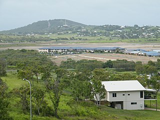
Taranganba is a town and locality in the Livingstone Shire, Queensland, Australia. In the 2016 census, the locality of Taranganba had a population of 2,276 people.

Coowonga is a rural locality in the Shire of Livingstone, Central Queensland, Australia. In the 2021 census, Coowonga had a population of 255 people.

<span class="mw-page-title-main">Lammermoor, Queensland</span> Suburb of Shire of Livingstone, Queensland, Australia

Lammermoor is a coastal locality on the Capricorn Coast in the Livingstone Shire, Queensland, Australia. In the 2016 census, Lammermoor had a population of 2,167 people.

<span class="mw-page-title-main">Mount Chalmers, Queensland</span> Town in Queensland, Australia

Mount Chalmers is a rural town and locality in the Livingstone Shire, Queensland, Australia. In the 2016 census, the locality of Mount Chalmers had a population of 235 people.

<span class="mw-page-title-main">Cawarral</span> Town in Queensland, Australia

Cawarral is a rural town and locality in the Livingstone Shire, Queensland, Australia. In the 2016 census the locality of Cawarral had a population of 831 people.

Adelaide Park is a rural locality in the Livingstone Shire, Queensland, Australia. In the 2016 census, Adelaide Park had a population of 424 people.

Barmaryee is a rural locality in the Livingstone Shire, Queensland, Australia. In the 2016 census, Barmaryee had a population of 878 people.

<span class="mw-page-title-main">Causeway Lake, Queensland</span> Suburb of Shire of Livingstone, Queensland, Australia

Causeway Lake is a coastal locality on the Capricorn Coast in the Livingstone Shire, Queensland, Australia. In the 2016 census, Causeway Lake had a population of 121 people.

<span class="mw-page-title-main">Thompson Point, Queensland</span> Suburb of Livingstone Shire, Queensland, Australia

Thompson Point is a coastal locality in the Livingstone Shire, Queensland, Australia. It was the site of a short-lived town and port called Broadmount. In the 2021 census, Thompson Point had a population of 4 people.

<span class="mw-page-title-main">Lower Daintree, Queensland</span> Suburb of Shire of Douglas, Queensland, Australia

Lower Daintree is a coastal rural locality in the Shire of Douglas, Queensland, Australia. In the 2021 census, Lower Daintree had a population of 83 people.

Hidden Valley is a rural locality in the Livingstone Shire, Queensland, Australia. In the 2016 census, Hidden Valley had a population of 421 people.

Rockhampton–Emu Park Road is a continuous 44.1 kilometres (27.4 mi) road route in the Rockhampton and Livingstone local government areas of Queensland, Australia. The route is designated as State Route 4 (Regional) and Tourist Drive 10. It is a state-controlled regional road.

References

  1. Australian Bureau of Statistics (28 June 2022). "Coorooman (Suburb and Locality)". Australian Census 2021 QuickStats. Retrieved 28 June 2022.  OOjs UI icon edit-ltr-progressive.svg
  2. 1 2 "Coorooman – locality in Livingstone Shire (entry 48583)". Queensland Place Names. Queensland Government . Retrieved 26 October 2019.
  3. 1 2 Australian Bureau of Statistics (28 June 2022). "Coorooman (SAL)". 2021 Census QuickStats. Retrieved 28 February 2023. OOjs UI icon edit-ltr-progressive.svg
  4. Google (20 August 2021). "Coorooman, Queensland" (Map). Google Maps . Google. Retrieved 20 August 2021.
  5. 1 2 3 4 "Queensland Globe". State of Queensland . Retrieved 31 August 2023.
  6. Google (6 August 2022). "Coorooman, Queensland" (Map). Google Maps . Google. Retrieved 6 August 2022.
  7. "SKETCHER". The Queenslander . No. 2454. Queensland, Australia. 28 March 1914. p. 8. Archived from the original on 2 December 2020. Retrieved 27 October 2019 via National Library of Australia.
  8. Australian Bureau of Statistics (27 June 2017). "Coorooman (SSC)". 2016 Census QuickStats. Retrieved 20 October 2018. OOjs UI icon edit-ltr-progressive.svg
  9. "Coorooman Creek". Yeppoon, Capricorn Coast. Retrieved 1 September 2023.
  10. "Recreational Boating Facilities Queensland". Queensland Open Data. Queensland Government. 12 November 2020. Archived from the original on 22 November 2020. Retrieved 22 November 2020.