Canal Creek

Last updated

Map all coordinates using: OpenStreetMap
Canal Creek
Queensland
Melaleuca viridiflora habit.jpg
Melaleuca viridiflora in Canal Creek
Australia Queensland location map.svg
Red pog.svg
Canal Creek
Coordinates 22°56′42″S150°23′43″E / 22.945°S 150.3952°E / -22.945; 150.3952 (Canal Creek (centre of locality))
Postcode(s) 4702
Area537.3 km2 (207.5 sq mi)
Time zone AEST (UTC+10:00)
Location
LGA(s) Livingstone Shire
State electorate(s)
Federal division(s) Capricornia
Suburbs around Canal Creek:
Kunwarara Shoalwater Byfield
Kunwarara Canal Creek Maryvale
Canoona Jardine
Rossmoya
Greenlake

Canal Creek is a rural locality in the Livingstone Shire, Queensland, Australia. [1] In the 2021 census, Canal Creek had a population of 11 people. [2]

Contents

Geography

The ridge of the Pointer Range forms the south-western boundary of the locality. [3] The terrain in the locality ranges from flatter land at approx 20 metres (66 ft) above sea level to numerous named peaks including (from west to east): [4]

Three creeks enter through the locality from the north (Shoalwater) flowing south, Alligator Creek to Canoona/Jardine and Canal Creek (from which the locality presumably takes its name) and Werribee Creek to Rossmoya. [4] These creeks are ultimately tributaries to the Fitzroy River which enters the Coral Sea between Thompsons Point and Port Alma. [4]

There are a number of protected areas in the locality, including: [4]

The predominant land use is grazing on native vegetation, plantation forestry and a small amount of crop growing. [4]

History

On 19 December 1943 a USA military aircraft crashed at Canal Creek Cattle Station and 31 people were killed. The C47 aircraft of 22nd Troop Carrier Squadron 374th Transport Group was flying from Townsville to Brisbane with a stop in Rockhampton. The port engine caught fire, which caused an explosion and the plane crashed and all 31 people on board were killed. The aircraft was carrying 20 USA military personnel, 8 Australian military personnel, and three civilians (one from the YMCA, one from the Salvation Army, and a war photographer). On 16 June 2002 a memorial to the crash was officially dedicated; it is at 22°58′47″S150°28′53″E / 22.97974°S 150.48141°E / -22.97974; 150.48141 (Canal Creek Air Crash monument) approximately 1 kilometre (0.62 mi) from the crash site due to the boggy terrain at the site. The memorial was organised by Yeppoon resident John Millroy. It was the 2nd worst aircrash in Australia's history (Bakers Creek air crash in June 1943 killed 40 people). [5] [6] [7]

Demographics

In the 2016 census, Canal Creek had a population of 8 people. [8]

In the 2021 census, Canal Creek had a population of 11 people. [2]

Education

There are no schools in Canal Creek. The nearest government primary school is Milman State School in Millman to the south. The nearest government secondary schools are Yeppoon State High School in Yeppoon to the south-east and Glenmore State High school in Kawana, Rockhampton to the south. The north-western parts of Canal Creek are too distant from these secondary schools for a daily commute, so distance education and boarding school are other options. [4]

Related Research Articles

<span class="mw-page-title-main">Yeppoon</span> Town in Queensland, Australia

Yeppoon is a coastal town and locality in the Shire of Livingstone, Queensland, Australia. Yeppoon is renowned for its beaches, tropical climate, and the islands out on the bay. Located 41 kilometres (25 mi) from the city of Rockhampton, Yeppoon is the seat of the Shire of Livingstone and the principal town on the Capricorn Coast, a string of seaside communities stretching more than 150 kilometres (93 mi) from north to south. The beaches and shallow coves provide a destination both for tourists and retirees settling down in Central Queensland. Offshore, there are 27 islands including Great Keppel Island which is 20 kilometres (12 mi) from Yeppoon. In the 2021 census, the locality of Yeppoon had a population of 7,037 people; this does not include any neighbouring suburbs.

<span class="mw-page-title-main">Kinka Beach, Queensland</span> Suburb of Shire of Livingstone, Queensland, Australia

Kinka Beach is a coastal rural locality in the Livingstone Shire, Queensland, Australia. In the 2016 census, Kinka Beach had a population of 621 people.

<span class="mw-page-title-main">Keppel Sands, Queensland</span> Town in Queensland, Australia

Keppel Sands is a coastal rural town and locality in the Livingstone Shire, Queensland, Australia. In the 2016 census, the locality of Keppel Sands had a population of 360 people.

<span class="mw-page-title-main">Derek Mollison</span> Australian rules footballer

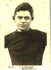
Crawford Derek Mollison was an Australian rules footballer who played with Melbourne in the Victorian Football League (VFL). He died while serving in the Second Australian Imperial Force when an aircraft in which he was a passenger crashed at Canal Creek, near Yaamba, Queensland.

Bangalee is a rural locality in the Livingstone Shire, Queensland, Australia. In the 2021 census, Bangalee had a population of 225 people.

<span class="mw-page-title-main">Zilzie</span> Suburb of Shire of Livingstone, Queensland, Australia

Zilzie is a coastal locality in the Livingstone Shire, Queensland, Australia. In the 2021 census, Zilzie had a population of 2,846 people.

<span class="mw-page-title-main">Taranganba</span> Town in Queensland, Australia

Taranganba is a town and locality in the Livingstone Shire, Queensland, Australia. In the 2016 census, the locality of Taranganba had a population of 2,276 people.

Coowonga is a rural locality in the Shire of Livingstone, Central Queensland, Australia. In the 2021 census, Coowonga had a population of 255 people.

<span class="mw-page-title-main">Lammermoor, Queensland</span> Suburb of Shire of Livingstone, Queensland, Australia

Lammermoor is a coastal locality on the Capricorn Coast in the Livingstone Shire, Queensland, Australia. In the 2016 census, Lammermoor had a population of 2,167 people.

<span class="mw-page-title-main">Mount Chalmers, Queensland</span> Town in Queensland, Australia

Mount Chalmers is a rural town and locality in the Livingstone Shire, Queensland, Australia. In the 2016 census, the locality of Mount Chalmers had a population of 235 people.

Adelaide Park is a rural locality in the Livingstone Shire, Queensland, Australia. In the 2016 census, Adelaide Park had a population of 424 people.

Barmaryee is a rural locality in the Livingstone Shire, Queensland, Australia. In the 2016 census, Barmaryee had a population of 878 people.

<span class="mw-page-title-main">Scenic Highway (Queensland)</span>

The Scenic Highway is a coastal highway from Yeppoon to Emu Park, both on the Capricorn Coast in the Shire of Livingstone, Queensland, Australia.

Bungundarra is a rural locality in the Livingstone Shire, Queensland, Australia. In the 2016 census, Bungundarra had a population of 536 people.

Lakes Creek is a suburb split between Rockhampton Region and Shire of Livingstone, Queensland, Australia. In the 2016 census Lakes Creek had a population of 552 people.

Jardine is a rural locality in the Livingstone Shire, Queensland, Australia. In the 2016 census Jardine had a population of 59 people.

<span class="mw-page-title-main">Thompson Point, Queensland</span> Suburb of Livingstone Shire, Queensland, Australia

Thompson Point is a coastal locality in the Livingstone Shire, Queensland, Australia. It was the site of a short-lived town and port called Broadmount. In the 2021 census, Thompson Point had a population of 4 people.

<span class="mw-page-title-main">Canal Creek air crash</span>

The Canal Creek air crash occurred on 19 December 1943 when a C-47 aircraft of the 22d Troop Carrier Squadron 374th Troop Carrier Group crashed at Canal Creek, Queensland, fifty kilometres north of Rockhampton, killing all 31 people on board.

Hidden Valley is a rural locality in the Livingstone Shire, Queensland, Australia. In the 2016 census, Hidden Valley had a population of 421 people.

Kunwarara is a rural locality in the Livingstone Shire, Queensland, Australia. In the 2016 census Kunwarara had a population of 71 people.

References

  1. "Canal Creek – locality in Livingstone Shire (entry 48559)". Queensland Place Names. Queensland Government . Retrieved 11 June 2019.
  2. 1 2 Australian Bureau of Statistics (28 June 2022). "Canal Creek (SAL)". 2021 Census QuickStats. Retrieved 28 February 2023. OOjs UI icon edit-ltr-progressive.svg
  3. "Pointer Range – range in the Shire of Livingstone (entry 27184)". Queensland Place Names. Queensland Government . Retrieved 18 October 2019.
  4. 1 2 3 4 5 6 "Queensland Globe". State of Queensland . Retrieved 17 October 2019.
  5. Roberts, Alice; Mackay, Jacquie (22 May 2012). "A site to remember: Canal Creek air disaster]". ABC Capricornia . Australian Broadcasting Corporation. Archived from the original on 10 March 2022. Retrieved 3 October 2019.
  6. "Canal Creek Air Crash". Monument Australia. Archived from the original on 17 October 2019. Retrieved 18 October 2019.
  7. "Crash of C-47 of 22nd Troop Carrier Squadron 374th Transport Group". Oz at War. Archived from the original on 27 August 2019.
  8. Australian Bureau of Statistics (27 June 2017). "Canal Creek (SSC)". 2016 Census QuickStats. Retrieved 20 October 2018. OOjs UI icon edit-ltr-progressive.svg