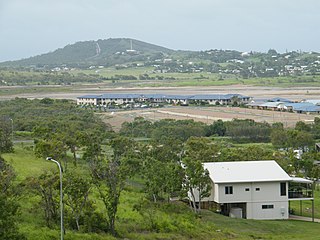
Barmaryee, Queensland

Last updated

Map all coordinates using: OpenStreetMap  
Download coordinates as: KML
Barmaryee
Queensland
Australia Queensland location map.svg
Red pog.svg
Barmaryee
Coordinates 23°08′42″S150°42′29″E / 23.145°S 150.7080°E / -23.145; 150.7080 (Barmaryee (centre of locality)) Coordinates: 23°08′42″S150°42′29″E / 23.145°S 150.7080°E / -23.145; 150.7080 (Barmaryee (centre of locality))
Population878 (2016 census) [1]
 • Density69.13/km2 (179.1/sq mi)
Postcode(s) 4703
Area12.7 km2 (4.9 sq mi)
Time zone AEST (UTC+10:00)
Location
LGA(s) Shire of Livingstone
State electorate(s) Keppel
Federal division(s) Capricornia
Suburbs around Barmaryee:
Lake Mary Adelaide Park Inverness
Lake Mary Barmaryee Yeppoon
Lake Mary Bondoola Hidden Valley

Barmaryee is a rural locality in the Livingstone Shire, Queensland, Australia. [2] In the 2016 census, Barmaryee had a population of 878 people. [1]

Contents

Geography

The land use is a mix of rural residential and grazing land in the west of the locality, suburban residential development in the east of the locality, with the south of the locality containing the racecourse and the landfill. [3]

The Rockhampton-Yeppoon Road (as Yeppoon Road) runs along part of the southern boundary. [4]

History

In the 2016 census, Barmaryee had a population of 878 people. [1] 86.9% of people were born in Australia and 93.7% of people only spoke English at home. The most common responses for religion were Catholic 32.9%, Anglican 20.2% and No Religion 18.6%. [1]

Education

There are no schools in Barmaryee. The nearest government primary school is Yeppoon State School in neighbouring Yeppoon to the east. The nearest government secondary school is Yeppoon State High School, also in Yeppoon. [3]

Facilities

Yeppoon Landfill is at 2745 Yeppoon Road ( 23°09′23″S150°42′24″E / 23.1564°S 150.7067°E / -23.1564; 150.7067 (Yeppoon Landfill) ). It is operated by Livingstone Shire Council. [5]

Amenities

There are a number of parks in the locality, including:

Attractions

Yeppoon Turf Club operates Keppel Park Racecourse is at 65 Racecourse Road ( 23°08′42″S150°42′18″E / 23.1449°S 150.7051°E / -23.1449; 150.7051 (Keppel Park Racecourse) ). [7]

Related Research Articles

Yeppoon Town in Queensland, Australia

Yeppoon is a coastal town and locality in the Shire of Livingstone, Queensland, Australia. Yeppoon is renowned for its beaches, tropical climate, and the islands out on the bay. Twenty-five minutes from the city of Rockhampton, Yeppoon is the principal town on the Capricorn Coast, a string of seaside communities stretching more than 150 kilometres (93 mi) from north to south. The beaches and shallow coves provide a destination both for tourists and retirees settling down in Central Queensland. Offshore, there are 27 islands including Great Keppel Island which is 20 kilometres (12 mi) from Yeppoon.

Capricorn Coast Region in Queensland, Australia

The Capricorn Coast is a stretch of coastline in Central Queensland, Australia and is part of the Shire of Livingstone.

Emu Park, Queensland Town in Queensland, Australia

Emu Park is a coastal town and locality on the Capricorn Coast located 21 kilometres (13 mi) south of Yeppoon in Queensland, Australia. It is within the local government area of Shire of Livingstone. In the 2016 census the locality of Emu Park had a population of 2,130 people.

Shire of Livingstone Local government area in Queensland, Australia

The Shire of Livingstone is a local government area located in the Capricornia region of Central Queensland, Queensland, Australia, to the immediate north and east of the regional city of Rockhampton. The shire, administered from the coastal town of Yeppoon, covers an area of 11,758 square kilometres (4,539.8 sq mi), and existed as a local government entity from 1879 until 2008, when it amalgamated with several other councils to become the Rockhampton Region. The Shire was re-established on 1 January 2014 following a successful de-amalgamation referendum in 2013.

Keppel Bay

Keppel Bay is a bay in Central Queensland, Australia at the mouth of the Fitzroy River on the coast of the Coral Sea.

Kinka Beach, Queensland Town in Queensland, Australia

Kinka Beach is a coastal rural locality in the Livingstone Shire, Queensland, Australia. In the 2016 census, Kinka Beach had a population of 621 people.

Keppel Sands, Queensland Town in Queensland, Australia

Keppel Sands is a coastal rural town and locality in the Livingstone Shire, Queensland, Australia. In the 2016 census, Keppel Sands had a population of 360 people.

Zilzie Suburb of Shire of Livingstone, Queensland, Australia

Zilzie is a coastal locality in the Livingstone Shire, Queensland, Australia. In the 2016 census, Zilzie had a population of 2,713 people.

Cooee Bay Suburb of Shire of Livingstone, Queensland, Australia

Cooee Bay is a coastal locality in the Livingstone Shire, Queensland, Australia. In the 2016 census Cooee Bay had a population of 913 people.

Taranganba is a town and locality on the tropical Central Queensland coast in Australia. It is within the local government area of Shire of Livingstone.

Lammermoor, Queensland Suburb of Shire of Livingstone, Queensland, Australia

Lammermoor is a coastal locality on the Capricorn Coast in the Livingstone Shire, Queensland, Australia. In the 2016 census, Lammermoor had a population of 2,167 people.

Mount Chalmers, Queensland Town in Queensland, Australia

Mount Chalmers is a rural town and locality in the Livingstone Shire, Queensland, Australia. In the 2016 census, the locality of Mount Chalmers had a population of 235 people.

Cawarral Town in Queensland, Australia

Cawarral is a rural town and locality in the Livingstone Shire, Queensland, Australia. In the 2016 census the locality of Cawarral had a population of 831 people.

Adelaide Park is a rural locality in the Livingstone Shire, Queensland, Australia. In the 2016 census, Adelaide Park had a population of 424 people.

Rosslyn, Queensland Town in Queensland, Australia

Rosslyn is a coastal town and locality in the Livingstone Shire, Queensland, Australia. In the 2016 census, the locality of Rosslyn had a population of 574 people.

Bungundarra is a rural locality in the Livingstone Shire, Queensland, Australia. In the 2016 census, Bungundarra had a population of 536 people.

Pacific Heights is a semi-rural locality in the Livingstone Shire, Queensland, Australia. In the 2016 census, Pacific Heights had a population of 926 people.

Thompson Point, Queensland Suburb of Livingstone Shire, Queensland, Australia

Thompson Point is a coastal locality in the Livingstone Shire, Queensland, Australia. In the 2016 census Thompson Point had a population of 10 people. It was the site of a short-lived town and port called Broadmount.

Hidden Valley is a rural locality in the Livingstone Shire, Queensland, Australia. In the 2016 census, Hidden Valley had a population of 421 people.

Mulara is a rural locality in the Livingstone Shire, Queensland, Australia. In the 2016 census, Mulara had a population of 89 people.

References

  1. 1 2 3 4 Australian Bureau of Statistics (27 June 2017). "Barmaryee (SSC)". 2016 Census QuickStats. Retrieved 20 October 2018. OOjs UI icon edit-ltr-progressive.svg
  2. "Barmaryee – locality in Livingstone Shire (entry 48510)". Queensland Place Names. Queensland Government . Retrieved 27 December 2020.
  3. 1 2 "Queensland Globe". State of Queensland . Retrieved 1 April 2021.
  4. Google (23 April 2022). "Barmaryee, Queensland" (Map). Google Maps . Google. Retrieved 23 April 2022.
  5. "Collection and Management". Livingstone Shire Council . Archived from the original on 11 March 2021. Retrieved 1 April 2021.
  6. 1 2 3 "Land for public recreation - Queensland". Queensland Open Data. Queensland Government. 20 November 2020. Archived from the original on 22 November 2020. Retrieved 22 November 2020.
  7. "Yeppoon Turf Club Inc". Racing Queensland. Archived from the original on 25 September 2020. Retrieved 1 April 2021.