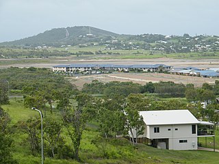
Yeppoon is a coastal town and locality in the Shire of Livingstone, Queensland, Australia. Yeppoon is renowned for its beaches, tropical climate, and the islands out on the bay. Located 41 kilometres (25 mi) from the city of Rockhampton, Yeppoon is the seat of the Shire of Livingstone and the principal town on the Capricorn Coast, a string of seaside communities stretching more than 150 kilometres (93 mi) from north to south. The beaches and shallow coves provide a destination both for tourists and retirees settling down in Central Queensland. Offshore, there are 27 islands including Great Keppel Island which is 20 kilometres (12 mi) from Yeppoon. In the 2021 census, the locality of Yeppoon had a population of 7,037 people; this does not include any neighbouring suburbs.

Kinka Beach is a coastal rural locality in the Livingstone Shire, Queensland, Australia. In the 2021 census, Kinka Beach had a population of 674 people.

Mount Britton is a rural locality in the Isaac Region, Queensland, Australia. In the 2021 census, Mount Britton had a population of 4 people. It contains the historic site of the abandoned former gold rush town of Mount Britten in the former Nebo Shire.

Zilzie is a coastal locality in the Livingstone Shire, Queensland, Australia. In the 2021 census, Zilzie had a population of 2,846 people.

Cooee Bay is a coastal locality in the Livingstone Shire, Queensland, Australia. In the 2021 census, Cooee Bay had a population of 942 people.

Lammermoor is a coastal locality on the Capricorn Coast in the Livingstone Shire, Queensland, Australia. In the 2016 census, Lammermoor had a population of 2,167 people.

Nerimbera is a rural locality in the Livingstone Shire, Queensland, Australia. In the 2016 census, Nerimbera had a population of 293 people.

Mount Chalmers is a rural town and locality in the Livingstone Shire, Queensland, Australia. In the 2016 census, the locality of Mount Chalmers had a population of 235 people.

The Caves is a rural town and locality in the Livingstone Shire, Queensland, Australia. In the 2016 census the locality of The Caves had a population of 718 people.
Adelaide Park is a rural locality in the Livingstone Shire, Queensland, Australia. In the 2021 census, Adelaide Park had a population of 449 people.
Barmaryee is a rural locality in the Livingstone Shire, Queensland, Australia. In the 2021 census, Barmaryee had a population of 925 people.

Rosslyn is a coastal town and locality in the Livingstone Shire, Queensland, Australia. In the 2016 census, the locality of Rosslyn had a population of 574 people.
Bungundarra is a rural locality in the Livingstone Shire, Queensland, Australia. In the 2021 census, Bungundarra had a population of 667 people.
Pacific Heights is a semi-rural locality in the Livingstone Shire, Queensland, Australia. In the 2016 census, Pacific Heights had a population of 926 people.
Maryvale is a rural locality in the Livingstone Shire, Queensland, Australia. In the 2021 census, Maryvale had a population of 48 people.
Mount Gardiner is a rural locality in the Livingstone Shire, Queensland, Australia. In the 2021 census, Mount Gardiner had a population of 19 people.

Canal Creek is a rural locality in the Livingstone Shire, Queensland, Australia. In the 2021 census, Canal Creek had "no people or a very low population".

Thompson Point is a coastal locality in the Livingstone Shire, Queensland, Australia. It was the site of a short-lived town and port called Broadmount. In the 2021 census, Thompson Point had a population of 4 people.
Lake Mary is a rural locality in the Livingstone Shire, Queensland, Australia. In the 2021 census, Lake Mary had a population of 96 people.
Kunwarara is a rural locality in the Livingstone Shire, Queensland, Australia. In the 2021 census, Kunwarara had a population of 69 people.


