Mulambin, Queensland

Last updated

Mulambin
Queensland
Great Keppel Island.jpg
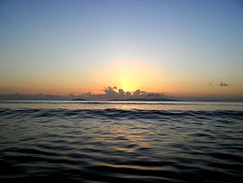
Sunrise from Mulambin Beach looking out towards Great Keppel Island, 2012
Australia Queensland location map.svg
Red pog.svg
Mulambin
Coordinates 23°11′52″S150°47′19″E / 23.1978°S 150.7885°E / -23.1978; 150.7885 Coordinates: 23°11′52″S150°47′19″E / 23.1978°S 150.7885°E / -23.1978; 150.7885
Postcode(s) 4703
LGA(s) Shire of Livingstone
State electorate(s) Keppel
Federal Division(s) Capricornia
Localities around Mulambin:
Rosslyn Rosslyn Rosslyn
Causeway Lake Mulambin Coral Sea
Causeway Lake Causeway Lake Causeway Lake

Mulambin is a coastal town and a locality on the Capricorn Coast in the Shire of Livingstone, Queensland, Australia. [1] [2]

Suburbs and localities are the names of geographic subdivisions in Australia, used mainly for address purposes. The term locality is used in rural areas, while the term suburb is used in urban areas. Australian postcodes closely align with the boundaries of localities and suburbs.

Capricorn Coast Region in Queensland, Australia

The Capricorn Coast is a stretch of coastline in Central Queensland, Australia and is part of the Shire of Livingstone. The region straddles the Tropic of Capricorn, after which it is named.

Shire of Livingstone Local government area in Queensland, Australia

The Shire of Livingstone is a local government area located in the Capricornia region of Central Queensland, Queensland, Australia, to the immediate north and east of the regional city of Rockhampton. The shire, administered from the coastal town of Yeppoon, covers an area of 11,776.3 square kilometres (4,546.9 sq mi), and existed as a local government entity from 1879 until 2008, when it amalgamated with several other councils to become the Rockhampton Region. The Shire was re-established on 1 January 2014 following a successful de-amalgamation referendum in 2013.

Contents

Geography

The eastern boundary of Mulambin is the beach fronting onto the Coral Sea. The Scenic Highway runs from the north to the south as an esplanade between the beach and the residential area. The western boundary is Mulambin Creek which flows from the north to the south into Causeway Lake. The western part of the locality is largely undeveloped freehold land. [3]

Coral Sea A marginal sea of the South Pacific off the northeast coast of Australia

The Coral Sea is a marginal sea of the South Pacific off the northeast coast of Australia, and classified as an interim Australian bioregion. The Coral Sea extends 2,000 kilometres (1,200 mi) down the Australian northeast coast.

The Scenic Highway is a coastal highway from Yeppoon to Emu Park, both on the Capricorn Coast in the Shire of Livingstone, Queensland, Australia.

Related Research Articles

Bowen, Queensland Town in Queensland, Australia

Bowen is a coastal town and locality in the Whitsunday Region on the eastern coast of Queensland, Australia. The town of Merinda and the Abbot Point coal shipping port are also within the locality of Bowen. At the 2016 census, Bowen had a population of 10,377.

Yeppoon Town in Queensland, Australia

Yeppoon is a coastal town and locality in the Shire of Livingstone, Central Queensland, Australia. Yeppoon is renowned for its beaches, tropical climate, and the islands out on the bay. Twenty-five minutes from the city of Rockhampton, Yeppoon is the principal town on the Capricorn Coast, a string of seaside communities stretching more than 150 kilometres (93 mi) from north to south. The beaches and shallow coves provide a destination both for tourists and miners settling down in Central Queensland. Offshore, there are 27 islands including Great Keppel Island which is 20 kilometres (12 mi) from Yeppoon.

Marlborough, Queensland Town in Queensland, Australia

Marlborough is a small town and locality in the Shire of Livingstone, Queensland, Australia. At the 2006 census, Marlborough and the surrounding area had a population of 355.

Hungerford, Queensland Town in Queensland, Australia

Hungerford is a outback town in the Shire of Bulloo and a locality in the Shire of Bulloo and Shire of Paroo, South West Queensland, Australia. It is immediately north of the border with New South Wales and the Dingo fence. At the 2016 census, Hungerford and the surrounding area within Queensland had a population of 23. The locality of Hungerford on the New South Wales side of the border had a population of 15.

Thallon, Queensland Town in Queensland, Australia

Thallon is a town and a locality in the Shire of Balonne, Queensland, Australia. In the 2016 census, Thallon had a population of 257 people.

Bangalee is a coastal locality within the local government area of Shire of Livingstone, Queensland, Australia. Between 2008 and 2013 it was within Rockhampton Region. At the 2006 census, Bangalee had a population of 469.

Taranganba Town in Queensland, Australia

Taranganba is a town and locality on the tropical Central Queensland coast in Australia. It is within the local government area of Shire of Livingstone. In the 2011 census, Taranganba had a population of 2,430 people.

Lammermoor, Queensland Queensland, Australia

Lammermoor is a coastal locality on the Capricorn Coast in the Shire of Livingstone, Queensland, Australia. Between 2008 and 2013, it was within the Rockhampton Region.

The Caves, Queensland Town in Queensland, Australia

The Caves is a small community and a locality in the Livingstone Shire, Queensland, Australia.

Adelaide Park, Queensland Suburb of Shire of Livingstone, Queensland, Australia

Adelaide Park is a locality in the Shire of Livingstone, Queensland, Australia.

Barlows Hill, Queensland Suburb of Shire of Livingstone, Queensland, Australia

Barlows Hill is a locality in the Shire of Livingstone, Queensland, Australia.
Ogmore, Queensland Town in Queensland, Australia

Ogmore is a town and coastal locality in the Shire of Livingstone, Queensland, Australia.

Rosslyn, Queensland Town in Queensland, Australia

Rosslyn is a coastal town and a locality on the Capricorn Coast in the Shire of Livingstone, Queensland, Australia.

Causeway Lake, Queensland Suburb of Shire of Livingstone, Queensland, Australia

Causeway Lake is a coastal locality on the Capricorn Coast in the Shire of Livingstone, Queensland, Australia.

Toobanna, Queensland Town in Queensland, Australia

Toobanna is a town and a locality in the Shire of Hinchinbrook, Queensland, Australia.

Deeral, Queensland Town in Queensland, Australia

Deeral is a town and a locality in the Cairns Region, Queensland, Australia.

Lakes Creek, Queensland Suburb of Rockhampton Region, Queensland, Australia

Lakes Creek is a suburb split between Rockhampton Region and Shire of Livingstone, Queensland, Australia.

Stanage, Queensland Town in Queensland, Australia

Stanage is a coastal town and a locality in the Livingstone Shire, Queensland, Australia.

Hurricane, Queensland Suburb of Shire of Mareeba, Queensland, Australia

Hurricane is a locality in the Shire of Mareeba, Queensland, Australia. It is a rural locality with no associated town. It contains a number of cattle stations, including Hurricane and Karma Waters. The entry gate to Hurricane station homestead is 195 kilometres (121 mi) north-west of Cairns via the Captain Cook Highway, Kennedy Highway, Mulligan Highway and Hurricane Road.
References

  1. "Mulambin - town in Shire of Livingstone (entry 23329)". Queensland Place Names. Queensland Government . Retrieved 9 July 2017.
  2. "Mulambin - locality in Shire of Livingstone (entry 48794)". Queensland Place Names. Queensland Government . Retrieved 9 July 2017.
  3. "Queensland Globe". State of Queensland . Retrieved 9 July 2017.

Commons-logo.svg Media related to Mulambin, Queensland at Wikimedia Commons