
Edithburgh is a small town on the south-east corner of Yorke Peninsula situated on the coastline of Salt Creek Bay, in the state of South Australia. Edithburgh is about 50 km (31 mi) west of Adelaide across Gulf St Vincent, but 226 km (140 mi) away by road. At the 2016 census, the locality had a population of 516 of which 454 lived in its town centre.

Wattle Point Wind Farm is a wind farm near Edithburgh on the Yorke Peninsula in South Australia, which has been operating since April 2005. When it was officially opened in June of that year it was Australia's largest wind farm at 91 megawatts (122,000 hp). The installation consists of 55 wind turbines covering 17.5 square kilometres (6.8 sq mi)and was built at a cost of 180 million Australian dollars. It is connected to ETSA Utilities electricity transmission system via a 132 kilovolt line.

Investigator Strait is a body of water in South Australia lying between the Yorke Peninsula, on the Australian mainland, and Kangaroo Island. It was named by Matthew Flinders after his ship, HMS Investigator, on his voyage of 1801–1802. It is bordered by the Gulf St Vincent in the northeast.

Cape Spencer is a headland in the Australian state of South Australia located on the south west tip of Yorke Peninsula in the gazetted locality of Inneston. It was named after George Spencer, 2nd Earl Spencer by Matthew Flinders during March 1802. It has been the site of an operating navigation aid since 1950 and has been located within the Innes National Park since 1970.

Point Perpendicular Light is a lighthouse located on Point Perpendicular, a point at the southern tip of the Beecroft Peninsula, in New South Wales, Australia. It marks and the northern entrance to Jervis Bay. The historic lighthouse was active from 1889 to 1993 and is still present, though its future is unclear. It is believed to be the first lighthouse in New South Wales which was built of precast concrete blocks. The light was replaced in 1993 with a skeletal tower which is active.

Point Charles Light, known officially as the Charles Point Lighthouse, is an active lighthouse located on a headland at the northern end of the Cox Peninsula, 21 kilometres (13 mi) northwest of Port Darwin, Northern Territory, Australia. Established in 1893, it is the oldest lighthouse in the Northern Territory.

Double Island Point Light is an active lighthouse located at the summit of Double Island Point, a coastal headland within the Cooloola section of the Great Sandy National Park. It is located at the southern end of Wide Bay, 70 kilometres (43 mi) north of Noosa Heads, Queensland, Australia.

Wyborn Reef Light is an active lighthouse located at Wyborn Reef, formerly known as Y Reef, about 16 kilometres (9.9 mi) southeast of Albany Island, east of the tip of Cape York Peninsula, Queensland, Australia. It marks the entrance to the Albany Passage. The lighthouse was constructed in 1938 and upgraded in 1991 and 1995. The structure is a stainless steel tower with a fiberglass hut within the framework, carrying a lantern.

SS Clan Ranald was a two decked, turret deck ship, which sank on 31 January 1909 in the Australian state of South Australia off the coast of Yorke Peninsula near the town of Edithburgh. It is the only turret ship to have been lost in Australian waters, and therefore represents a unique part of Australia's maritime history. The bulk of crew were Asian sailors (lascars). Clan Ranald is considered one of the worst shipwrecks in South Australia (SA) where only 24 survived out of the 64 crew members.

Troubridge Island is an island located in the south west corner of Gulf St Vincent in South Australia near the eastern edge of the Troubridge Shoals off the east coast of Yorke Peninsula about 8 kilometres (5.0 mi) southeast by east of the town of Edithburgh It is notable for being a site of an operating lighthouse from 1856 until 2002 and as a site for a sea bird rookery. Since 1982, the island has been part of the Troubridge Island Conservation Park.
Troubridge Island Conservation Park is a protected area includes all of Troubridge Island and some adjoining waters about 8 kilometres East-southeast of Edithburgh in South Australia and about 74 kilometres southwest of Adelaide. The park was proclaimed in 1982 under National Parks and Wildlife Act 1972 ‘to conserve sea-bird rookeries and to preserve heritage values of a lighthouse and associated keepers’ cottages’. In 1986 the park was extended to include an area of intertidal waters around the island. The conservation park is classified as an IUCN Category III protected area.

Troubridge Point is a headland in the Australian state of South Australia located on the south coast of Yorke Peninsula about 11 kilometres south west of Edithburgh. It is the western end of the opening to Gulf St Vincent.

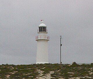
Troubridge Hill is a hill on the south coast of Yorke Peninsula in South Australia located in the locality of Honiton about 13.5 kilometres south west of Edithburgh and about 3.8 kilometres west of Troubridge Point. It was discovered, reported as being a ’hummock upon this low part ’ and named by Matthew Flinders on 24 March 1802 after Sir Thomas Troubridge, 1st Baronet. Since 1980, it has been the site of an operating lighthouse known as the Troubridge Hill Lighthouse. Its adjoining coastline borders a protected area of the same name - the Troubridge Hill Aquatic Reserve.
Sultana Point is a headland in the Australian state of South Australia located near the south east tip of Yorke Peninsula in the gazetted locality of Sultana Point about 3.3 kilometres south-southeast of the town of Edithburgh. The waters to its immediate east contain the shoal system known as the Troubridge Shoals. It is one of the natural features named after the Sultana, a ship which was wrecked on the Troubridge Shoals on 28 September 1849. The waters adjoining its shores are located within the boundaries of the Lower Yorke Peninsula Marine Park.
Warburto Point is a headland located on the west coast of the Yorke Peninsula in South Australia about 12 kilometres south west of the town of Wallaroo. The point is described by one source as being ‘a rocky projection that extends about 1.5 nautical miles W(est) from the mainland’ and that ‘it is 6.1 metres high and is fringed by mangroves along each of its sides.’ The land at the tip of the point has been part of the Bird Islands Conservation Park since 1972. Since 1995, it has been the site of a navigation aid in the form of a light tower which was commissioned to replace the lighthouse on Tiparra Reef. It is also the site of a coastal weather station operated by the Australian Bureau of Meteorology.
Sultana Point is a locality in the Australian state of South Australia located on the Yorke Peninsula immediately adjoining the western head of Gulf St Vincent about 80 kilometres west of the state capital of Adelaide.
Troubridge Island Lighthouse is a decommissioned lighthouse in the Australian state of South Australia located on Troubridge Island in Gulf St Vincent about 74 kilometres southwest of the state capital of Adelaide and about 8 kilometres (5.0 mi) southeast by east of Edithburgh on Yorke Peninsula.
Corny Point lighthouse is a lighthouse located in Spencer Gulf, South Australia on the headland known as Corny Point about 7.5 kilometres (4.7 mi) west of the town of Corny Point.
Honiton is a locality in the Australian state of South Australia located on the south coast of Yorke Peninsula immediately adjoining Investigator Strait about 89 kilometres west of the state capital of Adelaide and about 5 kilometres west of the Edithburgh town centre.
Troubridge Hill Aquatic Reserve is a marine protected area in the Australian state of South Australia located in Investigator Strait adjoining the south coast of Yorke Peninsula at the headland of Troubridge Hill.

