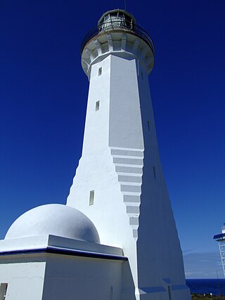
Before construction could begin, a jetty was built in Weirs Cove, 1mi (1.6km) north of the lighthouse,[6] and a flying fox erected to haul the materials up the 85m (279ft) cliff.[7] Construction of the lighthouse started in 1906 completed in 1909, the fifteenth positioned on the South Australian coast. The tower and keepers' cottages were constructed from 2000 pieces of local stone. The three four-roomed cottages were built to house the head lighthouse keeper and two assistants with their families, and there were also stables and outbuildings.[6] The lighthouse was fitted with a Chance Brothers lantern and First Order lens,[7] powered by kerosene.[6]
In 1915, the Commonwealth Government assumed control of all Australian lighthouses, but the takeover of Cape du Couedic did not occur until 1917.[6]
The first motor vehicle visited the lighthouse in 1940, although there was no proper road; up until this point, supplies were delivered to the jetty at Weirs Cove by boat once every three months.[6]
By the 1950s, shipping around Cape du Couedic had decreased significantly, with most vessels using the Backstairs Passage and Investigator Strait, so Cape du Couedic was automated and de-manned in 1957. The First Order lens, complete with mercury float pedestal, was removed and replaced by a Third Order fixed lens, lit by acetylene gas.[7] The cottages were transferred to the South Australian Government and incorporated into the Flinders Chase National Park.[6]
In 1991 restoration work on the three lighthouse-keeper's houses was undertaken, after which they became available for holiday rentals.[6] In 2000 further work was carried out, including the replacing the roofs with slate roofs, true to the original.[2][6]
The lighthouse tower is 25m (82ft) high.[7] The light characteristic shows two flashes every ten seconds, emitted at a focal plane height of 103 metres (338ft). A Third Order Fresnel lens made by Chance Brothers,[2] with a low voltage lamp and six-position lamp changer, is as of 2021[update] in operation.[7]
The original buildings are intact and preserved, and visitors to the area can stay in the three keepers' cottages,[2] while the lighthouse is a museum.[10] The lighthouse, its former keepers' cottages, stable and store, and the jetty, funnelway and the ruins of a store at Weirs Cove, have separate listings on the SA Heritage Register,[3][5] while the tower and cottages are also listed on the National Heritage List.[6]
Flinders Chase National Park is a protected area in the Australian state of South Australia located at the west end of Kangaroo Island about 177 kilometres west-south west of the state capital of Adelaide and 110 kilometres west of the municipal seat of Kingscote. It is a sanctuary for endangered species and home to a few geological phenomena. It was the second national park to be declared in South Australia.
Lincoln National Park is a protected area in the Australian state of South Australia located about 249 kilometres (155 mi) west of the state capital of Adelaide and about 9.5 kilometres (5.9 mi) south of the municipal seat of Port Lincoln. It consists of a mainland area on the Jussieu Peninsula on the south eastern tip of Eyre Peninsula and a number of nearby islands. The national park contains significant sites of natural, indigenous and early European heritage.
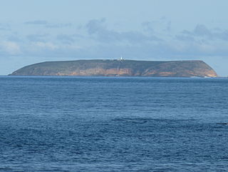
Kangaroo Island, also known as Karta Pintingga, is Australia's third-largest island, after Tasmania and Melville Island. It lies in the state of South Australia, 112 km (70 mi) southwest of Adelaide. Its closest point to the mainland is Snapper Point in Backstairs Passage, which is 13.5 km (8.4 mi) from the Fleurieu Peninsula.
Ravine Des Casoars Wilderness Protection Area is a protected area located on the west end of Kangaroo Island in South Australia about 80 km (50 mi) west of Kingscote. It was established in 1993 on land previously part of the Flinders Chase National Park.
Penneshaw is a township in the Australian state of South Australia located on the northeast coast of the Dudley Peninsula on Kangaroo Island about 107 kilometres (66 mi) south of the state capital of Adelaide. It is the island's main ferry port with regular services from Cape Jervis. Penneshaw features a Maritime and Folk Museum, and evening tours to a colony of little penguin, the only species of penguin to breed in Australian waters. At the 2011 census, Penneshaw had a population of 276.
Cape du Couedic is a headland in the Australian state of South Australia located on the southwest tip of Kangaroo Island in the locality of Flinders Chase. It was named after a French naval officer, Charles Louis du Couëdic de Kergoualer, by the Baudin expedition to Australia during January 1803. It is the site for the Cape du Couedic Lighthouse. It is currently located within the Flinders Chase National Park.
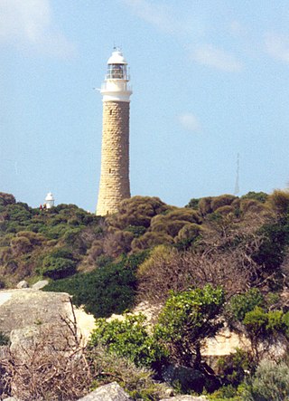
Cape Borda is a headland in the Australian state of South Australia located in the gazetted locality of Cape Borda on the north west tip of Kangaroo Island about 70 km (43 mi) west of the municipal seat of Kingscote. It was named after Jean-Charles de Borda (1733–1799), the French mathematician, physicist, naturalist and sailor, by the Baudin expedition to Australia during January 1803. It has been the site of an operating lighthouse since 1858 and is currently located within the Flinders Chase National Park.
Cape Borda Lighthouse is a lighthouse in the Australian state of South Australia located at Cape Borda on Kangaroo Island.
The Green Cape Lighthouse is a heritage-listed lighthouse located at the tip of Green Cape, a headland forming the northern boundary of Disaster Bay, in southern New South Wales, Australia. It is the southernmost lighthouse in New South Wales and Australia's first lighthouse built in concrete. At 29 metres (95 ft) it is also the tallest lighthouse in New South Wales. It marks Green Cape on the northerly shore-hugging sailing course.
Loch Vennachar was an iron-hulled, three-masted clipper ship that was built in Scotland in 1875 and lost with all hands off the coast of South Australia in 1905. She spent her entire career with the Glasgow Shipping Company, trading between Britain and Australia. The company was familiarly called the "Loch Line", as all of its ships were named after Scottish lochs. The ship was named after Loch Venachar, in what was then Perthshire.
Smoky Cape Lighthouse is a heritage-listed active lighthouse located on Smoky Cape, a headland in Arakoon east of the town of South West Rocks, Kempsey Shire, New South Wales, Australia, and within the Hat Head National Park. It directs boats towards the entrance to the Macleay River, which is located just to the north of the lighthouse.
The Montague Island Light is a heritage-listed active lighthouse located on Barunguba / Montague Island, an island in the Tasman Sea, 9 kilometres (5.6 mi) offshore from Narooma on the south coast of New South Wales, Australia. The lighthouse is located at the highest point of the island. It was designed by James Barnet and NSW Colonial Architect and built from 1878 to 1881 by J. Musson and completed By W. H. Jennings. It is also known as the Montague Island Lightstation and its setting. The property is owned by the Office of Environment and Heritage, an agency of the Government of New South Wales. It was added to the New South Wales State Heritage Register on 2 April 1999, and the Commonwealth Heritage List on 22 June 2004.
The Althorpe Islands are a group of islands in the Investigator Strait, off the south-western tip of Yorke Peninsula, South Australia. The group includes Althorpe Island and two rocky islets immediately to its west known as The Boobs. These are located 7.7 km south-southwest of Cape Spencer on the mainland. Closer inshore are Seal Island and Haystack Island, which together with Althorpe Island and The Boobs constitute the Althorpe Islands Conservation Park. A management plan for the Althorpe Islands Conservation Park was adopted in 2009. The islands are uninhabited and can only be accessed by sea or by helicopter.
Ravine des Casoars is a gorge and an associated drainage basin in the Australian state of South Australia located on the west coast of Kangaroo Island about 95 kilometres west of Kingscote.
Troubridge Island Lighthouse is a decommissioned lighthouse in the Australian state of South Australia located on Troubridge Island in Gulf St Vincent about 74 kilometres southwest of the state capital of Adelaide and about 8 kilometres (5.0 mi) southeast by east of Edithburgh on Yorke Peninsula.
Eddystone Point lies on the north-east coast of Tasmania, Australia at 40.994 S/148.349 E.
Maupertuis Bay is a bay in the Australian state of South Australia located on the south-west coastline of Kangaroo Island.
Cape Borda is a locality in the Australian state of South Australia located on Kangaroo Island about 192 kilometres south-west of the state capital of Adelaide.
Flinders Chase is a locality in the Australian state of South Australia located on the south-western coast of Kangaroo Island overlooking the body of water known in Australia as the Southern Ocean and by international authorities as the Great Australian Bight. It is located about 210 kilometres south-west of the state capital of Adelaide.
Voitre Marek, also known as Vojtěch Marek, was an Australian artist. He was born in Czechoslovakia and lived in South Australia from 1949. He is known for his surrealist style and religious art, in particular sculptures, some of which are held in churches around Australia.
This page is based on this Wikipedia article Text is available under the CC BY-SA 4.0 license; additional terms may apply. Images, videos and audio are available under their respective licenses.