
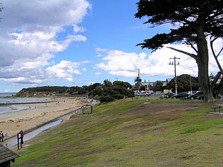
Queenscliff is a small town on the Bellarine Peninsula in southern Victoria, Australia, south of Swan Bay at the entrance to Port Phillip. It is the administrative centre for the Borough of Queenscliffe. At the 2016 census, Queenscliff had a population of 1,315.

Williamstown is a suburb in Melbourne, Victoria, Australia, 11 km (6.8 mi) south-west of Melbourne's Central Business District, located within the City of Hobsons Bay local government area. Williamstown recorded a population of 14,407 at the 2021 census.
Point Lonsdale is a coastal township on the Bellarine Peninsula, near Queenscliff, Victoria, Australia. The town is divided between the Borough of Queenscliffe and the City of Greater Geelong. Point Lonsdale is also one of the headlands which, with Point Nepean, frame The Rip, the entrance to Port Phillip. The headland is dominated by the Point Lonsdale Lighthouse. At the 2016 census, Point Lonsdale had a population of 2,684. The population grows rapidly over the summer months through to the Easter period due to its popularity as a holiday destination.

Hornby Lighthouse, also known as South Head Lower Light or South Head Signal Station, is a heritage-listed active lighthouse located on the tip of South Head, New South Wales, Australia, a headland to the north of the suburb Watsons Bay. It marks the southern entrance to Port Jackson and Sydney Harbour, as well as lighting the South Reef, a ledge of submerged rocks. It is the third oldest lighthouse in New South Wales. Designed by Mortimer Lewis and listed on the Register of the National Estate and on the New South Wales State Heritage Register since 2 April 1999, with the following statement of significance:
A dominant Sydney landmark which appears to have been in continuous use since the 1840s as a controlling point for shipping entering and leaving Port Jackson. The building complex, designed by the Colonial Architect Mortimer Lewis in the early 1840s, is an architectural important example of an early Victorian public work associated with port activities.
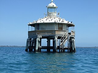
The South Channel Pile Light is a single-storey octagonal lighthouse in Port Phillip, Victoria, Australia.
A pile lighthouse is a type of lighthouse found in Australia and the United States. In the United States they are found primarily in Florida, including on open reefs adjacent to the Florida Keys.

Fort Queenscliff, in Victoria, Australia, dates from 1860 when an open battery was constructed on Shortland's Bluff to defend the entrance to Port Phillip. The Fort, which underwent major redevelopment in the late 1870s and 1880s, became the headquarters for an extensive chain of forts around Port Phillip Heads. Its garrison included volunteer artillery, engineers, infantry and naval militia, and it was manned as a coastal defence installation continuously from 1883 to 1946. The other fortifications and armaments around the Heads were completed by 1891, and together made Port Phillip one of the most heavily defended harbours in the British Empire.

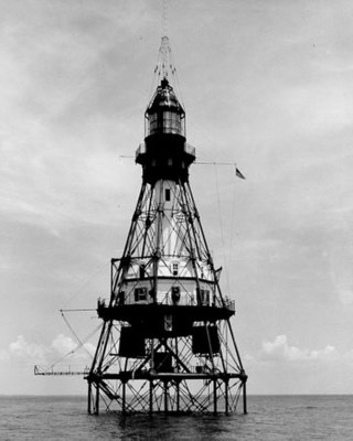
Moreton Bay Pile Light was a pile lighthouse positioned at the mouth of Brisbane River, in Moreton Bay, Queensland, Australia, marking the entrance to the port of Brisbane. The light's early history was closely related to the dredging of the Brisbane River. It was established in 1884 as a result of a new channel that was cut, and relocated in 1913 due to another change in the channels. The structure was badly damaged by a barge in 1945 and finally destroyed when hit by a tanker in 1949. An automated light operated on the ruins until 1966–1967 when it was removed.

Chinaman's Hat is an octagonal structure in the South Channel of Port Phillip, in the Australian state of Victoria, which serves as a shipping channel marker and haul-out for local brown fur seals. It is in the Mornington Peninsula Shire, 3 km (1.9 mi) east-south-east of Pope's Eye. Along with the latter, it served as a navigation beacon at the Heads of the bay.

Point Lonsdale Lighthouse, also known as the Point Lonsdale Signal Station, is close to the township of Point Lonsdale in the Borough of Queenscliffe, Victoria, Australia. It stands at the eastern end of the Bellarine Peninsula, on the western side of the entrance to Port Phillip from Bass Strait, on a headland overlooking the "Rip", a stretch of water considered one of the ten most treacherous navigable passages in the world, and the only seaborne approach to Melbourne. It is operated by Victorian Ports Corporation (Melbourne).

The Queenscliff Low Light, also known as the Queenscliff White Lighthouse, is a lighthouse in the township of Queenscliff in the Borough of Queenscliffe, Victoria, Australia, at the eastern end of the Bellarine Peninsula. It stands inside the entrance to Port Phillip from Bass Strait, on the lower slope of the Queenscliff Peninsula overlooking the ’Rip”, a stretch of water considered one of the ten most treacherous navigable passages in the world. It is operated by the Port of Melbourne Corporation.

Whalers Bluff Lighthouse is a lighthouse on Whalers Bluff, also known as Whalers Point, in the regional city of Portland in the Western District of the state of Victoria in Australia. It stands about 1.5 km north of the city centre and overlooks Portland's harbour. It is operated by the Victorian Channels Authority, part of the Port of Melbourne Corporation.
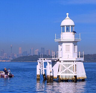
Eastern Channel Pile Light, also known as the East Wedding Cake due to its shape, is an active pile lighthouse located at the Sydney Harbour, New South Wales, Australia, off Laings Point in the Vaucluse suburb of Sydney. It marks the eastern end of the Sow and Pigs Reef.

Western Channel Pile Light, also known as the West Wedding Cake due to its shape, is an active pile lighthouse located at the Sydney Harbour, New South Wales, Australia, off Georges Head at Mosman. It marks the western end of the Sow and Pigs Reef. It collapsed in December 2006 and was reconstructed and restored to operation in December 2008.

Point Cartwright Light is an active lighthouse located on Point Cartwright, a point near the mouth of the Mooloolah River, in Mooloolaba, Queensland, Australia. It marks the entrance to the North West Channel, a deep water channel into Moreton Bay and the Port of Brisbane, and provides guidance into the Mooloolaba Harbour.
The Point Hicks Marine National Park is a protected marine national park in situated off Point Hicks in the East Gippsland region of Victoria, Australia. The 4,000-hectare (9,900-acre) marine park is situated approximately 450 kilometres (280 mi) east of Melbourne and 25 kilometres (16 mi) south of Cann River, adjacent to the Croajingolong National Park and Point Hicks Lighthouse Reserve.

Point Hicks Lighthouse is a lighthouse located on the Point Hicks headland, in the East Gippsland region of Victoria, Australia.

Griffiths Island, sometimes incorrectly spelled as Griffith Island or Griffitts Island, lies at the mouth of the Moyne River next to, and within the bounds of, the town of Port Fairy, in the Western District of the state of Victoria in Australia. Griffiths now has no permanent inhabitants, but is connected to the mainland by a causeway and is accessible on foot. It forms part of the Port Fairy and Belfast Coastline Protection Reserve and, as well as being a tourist attraction, is an important site in the context of the history of European settlement of western Victoria. It is managed by the Moyne Shire Council.

Boulder Bank Lighthouse is a decommissioned 19th century lighthouse located near the Port Nelson end of the Boulder Bank. It was New Zealand's second permanent lighthouse.

