
Booby Island Light is an active heritage-listed lighthouse located on Booby Island in the Shire of Torres, near the tip of Cape York Peninsula, west of Prince of Wales Island, within the Endeavour Strait, Queensland, Australia. It marks the western entrance to the navigation channel through the Torres Strait. It was the last of the major lights to be constructed along the Queensland coast.
The New Burnett Heads Light, also known as South Head Light, is an active lighthouse standing on the south side of the Burnett River entrance, in Burnett Heads, Queensland, Australia. In 1971 it replaced the Old Burnett Heads Light, which was relocated inland.

Bustard Head Light is an active lighthouse located on the southeast tip of Bustard Head, a headland, about 20 kilometres (12 mi) northwest of Seventeen Seventy, in the Australian state of Queensland, within the Eurimbula National Park and locality of Eurimbula. Built in 1868, it is the second-oldest lightstation in the state, following Cape Moreton Light, and the first to be built in Queensland after its formation in 1859. It is also one of the first in Australia to be constructed using bolted prefabricated segments of cast iron, and one of only two such lighthouses in Queensland, the other being its sibling, Sandy Cape Light. It serves as the central relay for Dent Island Light, Pine Islet Light and Lady Elliot Island Light and as the radio check post for Cape Capricorn Light, Sandy Cape Light and Double Island Point Light.

Sandy Cape Light is a heritage-listed active lighthouse located on Sandy Cape, the most northern point on K'gari, Queensland, Australia. It stands about 6 kilometres (3.7 mi) southwest of the northeastern tip of the island. It is the tallest lighthouse in Queensland. Built in 1870, it is the second major lighthouse to be built in Queensland after its formation in 1859. It is one of the first lighthouses in Australia to be constructed using bolted prefabricated segments of cast iron, and one of only two such lighthouses in Queensland, the other being its sibling, Bustard Head Light.
Old Caloundra Light, also known as Old Caloundra Head Light or Cape Caloundra Light, is an inactive lighthouse located in Caloundra on the Sunshine Coast in South East Queensland, Australia. It is the oldest surviving building in Caloundra. The lighthouse was active between 1896 and 1968. The tower was relocated twice. In 1970 it was relocated from its original location to Woorim Park in Caloundra, and in 1999 it was returned to its original site on Canberra Terrace near downtown Caloundra, where it stands today.
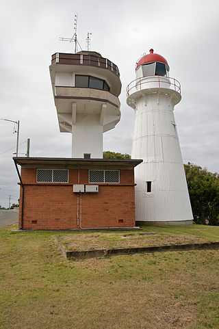
New Caloundra Light, also known as New Caloundra Head Light, is an inactive lighthouse located in Caloundra on the Sunshine Coast in South East Queensland, Australia. It stands on Canberra Terrace near downtown Caloundra. The lighthouse was active from 1968 to 1992. It has a unique design resembling an airport control tower, the only surviving example of a lighthouse of this design in Australia.
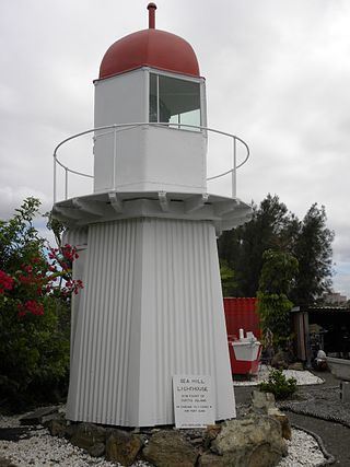
Sea Hill Lighthouse, also known as Sea Hill Point Light or Little Sea Hill Light, is a lighthouse on the northwest point of Curtis Island, Gladstone Region, Queensland, Australia. Its purpose was to mark the east side of the entrance to Keppel Bay, on passage to Fitzroy River and Port Alma. The first lighthouse at the locations was constructed in 1873 or 1876, moved in the 1920s, and is now on display at the Gladstone Maritime Museum. A second lighthouse was constructed in 1895 and its state is unclear.

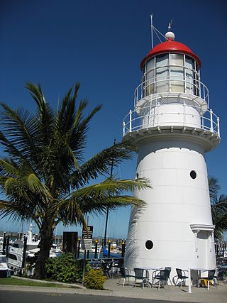
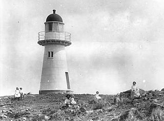
Point Cartwright Light is an active lighthouse located on Point Cartwright, a point near the mouth of the Mooloolah River, in Mooloolaba, Queensland, Australia. It marks the entrance to the North West Channel, a deep water channel into Moreton Bay and the Port of Brisbane, and provides guidance into the Mooloolaba Harbour.

Cape Bowling Green Light is an active lighthouse located on Cape Bowling Green, a lengthy headland ending with a long low sandspit, about 30 kilometres (19 mi) from Ayr, Queensland, Australia. The lighthouse is at the end of the headland, near the base of the sandspit. The first lighthouse at the location, established in 1874, was moved multiple times. It was prefabricated in Brisbane, shipped to the location, moved twice due to coastal erosion and finally transferred for display at the Australian National Maritime Museum at Darling Harbour in Sydney.

Lady Elliot Island Light is an active lighthouse located on Lady Elliot Island, the southernmost coral cay of the Great Barrier Reef, 46 nautical miles north-east of Bundaberg, Queensland, Australia. The lighthouse is located on the western side of the island. It was the third lighthouse erected in Queensland after its formation in 1859 and the first in Australia to be constructed of a timber frame clad with iron plates. The original lighthouse was deactivated in 1995 and the light was replaced by a modern skeletal tower standing close to the original lighthouse.

Cape Cleveland Light is an active heritage-listed lighthouse located on the northern tip of Cape Cleveland, a promontory projecting into the Coral Sea west of Cleveland Bay in the locality of Cape Cleveland about 40 kilometres (25 mi) east of Townsville, Queensland, Australia. The lighthouse marks the northern point of the Cape, and the entrance to Cleveland Bay.

Cleveland Point Light, also known as Point Cleveland Light, is a lighthouse located on the north-eastern tip of Cleveland Point, at Cleveland, Redland City, Queensland, Australia. It overlooks Moreton Bay to the east and Raby Bay to the west. The old lighthouse was established in 1864-1865 as a wooden hexagonal tower. It is one of only two surviving lighthouses of this form, the other being Old Burnett Heads Light. A newer light, constructed of a concrete post, replaced it in 1976, and the old lighthouse was relocated a short distance away, where it stands today. The newer light was removed in 2009.

Dent Island Light is an active lighthouse on Dent Island, a small island off the coast of Queensland, Australia, part of the Whitsunday Group of the Whitsunday Islands. Located on the southwest tip of the island, the light guides ships navigating the Whitsunday Passage, between Whitsunday Island and the islands to the west, and marks the Dent Island Passage.

Double Island Point Light is an active lighthouse located at the summit of Double Island Point, a coastal headland within the Cooloola section of the Great Sandy National Park. It is located at the southern end of Wide Bay, 70 kilometres (43 mi) north of Noosa Heads, Queensland, Australia.
Pine Islet Light, also known as Percy Isles Light, is an active lighthouse located at Pine Islet, a small islet belonging to the Percy Isles group of the Northumberland Islands, about 130 kilometres (81 mi) southeast of Mackay, Queensland, Australia. The original lighthouse, established 1885, was active for a hundred years, until it was deactivated in 1985, by then the last kerosene powered lighthouse in Australia. It was relocated to the Mackay Marina in 1985 and restored to full working condition, making it the last fully functional kerosene operated lighthouse in the world. At the original location now stands a modern fiberglass tower.

Moreton Island is a large sand island on the eastern side of Moreton Bay, on the coast of South East Queensland, Australia. Due to the island's importance in navigating the northern passage into Moreton Bay and Brisbane, at least five lighthouses were constructed on the island, starting with Cape Moreton Light in 1857, the first lighthouse in Queensland, and followed by at least four more lighthouses established from the 1860s, at Comboyuro Point, North Point, Cowan Cowan Point and Yellow Patch. Comboyuro Point Light, Cowan Cowan Point Light and Yellow Patch Light all had to be moved from their original location due to coastal erosion. Of the five lighthouses, only Cape Moreton Light survived and is still active today.
Comboyuro Point Light, which was also known later as Comboyuro Light, was located on Comboyuro Point, at the northwestern tip of Moreton Island. It is one of the Moreton Island lighthouses

Cowan Cowan Point Light, was also known as Cowan Cowan Light or Cowan Point Light, was located on Cowan Cowan Point, on the western shore of Moreton Island, Queensland, Australia.
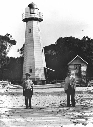
Flat Top Island Light is an inactive lighthouse located on Flat Top Island, a small island off the entrance to Mackay harbor at the mouth of Pioneer River, about 6.5 kilometres (4.0 mi) east of Mackay, Queensland, Australia. It used to mark the river entrance for shipping and the direction of the port, as well as highlighting close by shoals at Shoalwater Point and a reef off Hay Point. At 6 metres (20 ft) from the ground to the lantern floor, it is the shortest of Queensland's timber-framed iron clad lighthouses.


