New Caloundra Light

Last updated

New Caloundra Light
Caloundra Lighthouses, 2008.jpg
Old Caloundra Light on the right, New Caloundra Light on the left, 2008
New Caloundra Light
Location Caloundra
Queensland
Australia
Coordinates 26°48′05.63″S153°08′14.67″E / 26.8015639°S 153.1374083°E / -26.8015639; 153.1374083 Coordinates: 26°48′05.63″S153°08′14.67″E / 26.8015639°S 153.1374083°E / -26.8015639; 153.1374083
Tower
Constructed1967 [1]
Constructionconcrete tower
Automated1968
Height46 feet (14 m) [2]
Shapesquare tower supporting D-shaped observation room, lantern on roof
Markingswhite tower
Heritagelisted on the Queensland Heritage Register  OOjs UI icon edit-ltr-progressive.svg
Light
First lit1968
Deactivated1992 [3]
Focal height52 metres (171 ft)
Range24 nautical miles (44 km; 28 mi)
Characteristic Fl (2) W 10s.

New Caloundra Light, also known as New Caloundra Head Light, is an inactive lighthouse located in Caloundra on the Sunshine Coast in South East Queensland, Australia. It stands on Canberra Terrace near downtown Caloundra. The lighthouse was active from 1968 [1] to 1992. [3] It has a unique design resembling an airport control tower, the only surviving example of a lighthouse of this design in Australia. [4]

Contents

History

Old Caloundra Light had stood on Canberra Terrace since its construction in 1896, marking the entrance to the North West Channel, a deep water channel into Moreton Bay and the Port of Brisbane. Changes in the shipping industry in the 1960s caused an increase in large container ships, which made the channel even more important. In May 1966 permission was granted for the construction of a modern structure comprising a combined lighthouse, signal station and radar station. [4]

The New Caloundra Light was erected in 1967, [5] and was the second of a group of seven concrete towers erected between 1964 and 1979. By order of construction the lights were Cape Capricorn Light, New Caloundra Light, Point Danger Light, New Burnett Heads Light, Fitzroy Island Light, Point Cartwright Light and Archer Point Light. [4]

The light source was two stacks of sealed beam lamps, installed on a revolving table. [4] It had red and green sectors. While the light itself was fully automatic, the station was staffed due to the signal station. [5] Four houses were constructed outside the station to accommodate the staff. [4]

The tower was constructed right next to the old lighthouse. By 1968 it became fully operational and the old lighthouse was deactivated. In 1970 the old lighthouse was relocated to avoid demolition. [4]

The lighthouse had a short lifespan as a coastal light. By 1978 the buildings in Caloundra had grown in height, obscuring it from some angles. In 1978 Point Cartwright Light was constructed, [5] and the New Caloundra Light was downgraded to a harbour light. [6] The harbour light remained there until 1992, [7] when it was moved to Wickham Point, together with a radar/microwave link replacing the signal station, and the station was destaffed. New Caloundra Light remained as backup, until it was finally shut off in 1997. [5]

The lighthouse's last display had a light characteristic of two white flashes every ten seconds (Fl.G(2).W. 10s). The light was a 1,000,000  cd, 200  Watt, sealed beam array fed from Mains electricity with a battery backup, visible for 24 nautical miles (44 km; 28 mi). It was displayed at a focal height of 52 metres (171 ft). [5]

Structure

The lighthouse structure, totaling 14 metres (46 ft) in height, is quite unique, resembling an airport control tower. [8] It comprises a square tower carrying a semicircular D-shaped observation room, with the rounded side facing east, and a lantern room is mounted on the roof of the observation room. [4] While a similar structure was constructed at Lytton Hill, in Lytton, Queensland, serving as an observation tower, [9] it was demolished in the 1990s, leaving the New Caloundra Light as the only surviving example of this design. [4]

The tower base measures 2.7 metres (8 ft 10 in). The entrance is from the western side, and a spiral concrete staircase leads to the observation room. The stairs have a steel tubular handrail, and circle a service duct. One rectangular window is set in each of the four sides of the base, aligned with the staircase. Cantilevered reinforced concrete beams angle from the base to support the floor of the observation room. [4]

The observation room features windows on all sides. The eastern rounded side features a continuous band of windows, while the straight western side features four individual ones. The room includes an enclosed toilet in the northwest corner and central pillar with cavities linking to the roof level. A door in the southwest corner leads to a narrow balcony that wraps around the rounded part of the room. The balcony has a concrete floor and a balustrade covered in asbestos cement sheeting rendered with pebbledash on the exterior face. A steel ladder with safety grille on the northwest end leads to the flat roof. [4]

The roof is surrounded with a balustrade with fibre cement panels. The concrete constructed lantern room is located at the centre of the roof. It is a circular room with a flat concrete roof, wider at the roof than at the base. Trapezoidal steel frame window panes are set on the eastern side, the side facing the sea. The lantern can be accessed via a door on the southwest. A ladder on the northwest allows access to the roof of the lantern room, where radar and radio equipment is mounted. [4]

Another related structure is an orange brick generator shed just south of the lighthouse. It was built in 1967–1968 together with the lighthouse. Windows are set high on the wall, with a projecting brick window sill below. An overhanging concrete roof forms a narrow awning. Entrance to the structure is on the northern side. The inside is composed of two rooms, a larger generator room and a smaller room in the northwest with an internal door. [4]

Site operation and visiting

The site of the lighthouse is accessible, but the tower was originally closed to the public. [8] In 2011, the Friends of the Caloundra Lighthouses applied for a license from the Sunshine Coast Regional Council to allow visits to the 1968 signal station and lighthouse. [10] As of July 2012, the tower can be visited by contacting the Friends of the Caloundra Lighthouses.

See also

Notes

  1. 1 2 Note that there is some confusion over the dates, as most probably the tower was constructed in 1967 (per Searle and Lighthouses of Australia Inc) but was only made fully active by 1968 (date given by Rowlett and QHR31351).
  2. Rowlett. Searle lists 56 feet (17 m).
  3. 1 2 Rowlett. Lighthouses of Australia Inc says in the table that the light was active until 1997, but in the text it explains that since 1992 it only served as a backup.
  4. 1 2 3 4 5 6 7 8 9 10 11 12 QHR31351.
  5. 1 2 3 4 5 Lighthouses of Australia Inc.
  6. Rowlett. Lighthouses of Australia Inc states the downgrade was in 1974.
  7. Lighthouses of Australia Inc. QHR31351 states this as the date the signal station was destaffed, and states the light was moved "In the late 1990s".
  8. 1 2 Rowlett.
  9. QLD601366.
  10. Minutes.

Related Research Articles

<span class="mw-page-title-main">Norah Head Light</span> Lighthouse in New South Wales, Australia

Norah Head Light is an active lighthouse located at Norah Head, a headland on the Central Coast, New South Wales, Australia, close to Toukley. It is the last lighthouse of the James Barnet style to be built, and the last staffed lighthouse constructed in New South Wales.

<span class="mw-page-title-main">Archer Point Light</span> Lighthouse in Queensland, Australia

Archer Point Light is an active lighthouse on Archer Point, a conical, 60-metre-high (200 ft) grassy headland about 14 kilometres (8.7 mi) southeast of Cooktown, Queensland, Australia. Originally an 1883 timber frame lighthouse covered with galvanised iron, it was replaced in 1975 with a modern square concrete equipment room topped with a lantern.

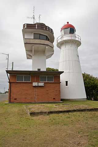
The New Burnett Heads Light, also known as South Head Light, is an active lighthouse standing on the south side of the Burnett River entrance, in Burnett Heads, Queensland, Australia. In 1971 it replaced the Old Burnett Heads Light, which was relocated inland.

<span class="mw-page-title-main">Bustard Head Light</span> Lighthouse

Bustard Head Light is an active lighthouse located on the southeast tip of Bustard Head, a headland, about 20 kilometres (12 mi) northwest of Seventeen Seventy, in the Australian state of Queensland, within the Eurimbula National Park and locality of Eurimbula. Built in 1868, it is the second-oldest lightstation in the state, following Cape Moreton Light, and the first to be built in Queensland after its formation in 1859. It is also one of the first in Australia to be constructed using bolted prefabricated segments of cast iron, and one of only two such lighthouses in Queensland, the other being its sibling, Sandy Cape Light. It serves as the central relay for Dent Island Light, Pine Islet Light and Lady Elliot Island Light and as the radio check post for Cape Capricorn Light, Sandy Cape Light and Double Island Point Light.

<span class="mw-page-title-main">Sandy Cape Light</span> Lighthouse

Sandy Cape Light is a heritage-listed active lighthouse located on Sandy Cape, the most northern point on K'gari, Queensland, Australia. It stands about 6 kilometres (3.7 mi) southwest of the northeastern tip of the island. It is the tallest lighthouse in Queensland. Built in 1870, it is the second major lighthouse to be built in Queensland after its formation in 1859. It is one of the first lighthouses in Australia to be constructed using bolted prefabricated segments of cast iron, and one of only two such lighthouses in Queensland, the other being its sibling, Bustard Head Light.

<span class="mw-page-title-main">Old Caloundra Light</span> Lighthouse

Old Caloundra Light, also known as Old Caloundra Head Light or Cape Caloundra Light, is an inactive lighthouse located in Caloundra on the Sunshine Coast in South East Queensland, Australia. It is the oldest surviving building in Caloundra. The lighthouse was active between 1896 and 1968. The tower was relocated twice. In 1970 it was relocated from its original location to Woorim Park in Caloundra, and in 1999 it was returned to its original site on Canberra Terrace near downtown Caloundra, where it stands today.

<span class="mw-page-title-main">Sea Hill Light</span> Lighthouse

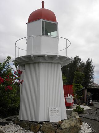
Sea Hill Lighthouse, also known as Sea Hill Point Light or Little Sea Hill Light, is a lighthouse on the northwest point of Curtis Island, Gladstone Region, Queensland, Australia. Its purpose was to mark the east side of the entrance to Keppel Bay, on passage to Fitzroy River and Port Alma. The first lighthouse at the locations was constructed in 1873 or 1876, moved in the 1920s, and is now on display at the Gladstone Maritime Museum. A second lighthouse was constructed in 1895 and its state is unclear.

<span class="mw-page-title-main">Grassy Hill Light</span> Lighthouse

Grassy Hill Light, also known as Cooktown Light, is an active lighthouse located on Grassy Hill above Cooktown, Queensland, Australia, on the south side of the entrance to Endeavour River.

<span class="mw-page-title-main">Goods Island Light</span> Lighthouse

Goods Island Light is an active lighthouse located on the highest point of Goods Island (Palilag), an island in the Torres Strait, belonging to Queensland, Australia. It serves as the rear light of the Goods Island Range, pointing out the entrance to Normanby Sound.

<span class="mw-page-title-main">Cape Capricorn Light</span> Lighthouse in Queensland, Australia

Cape Capricorn Light is an active heritage-listed lighthouse located on Cape Capricorn, a coastal headland on the northeast point of Curtis Island, in Gladstone Region, Central Queensland, Australia. The lighthouse, constructed in 1964, is the third at this site, following a timber frame lighthouse constructed in 1875 and a concrete lighthouse constructed around 1937. It was added to the Queensland Heritage Register on 31 August 2001.

<span class="mw-page-title-main">Point Danger Light</span> Lighthouse in New South Wales, Australia

Point Danger Light, also known as the Captain Cook Memorial Light, is an active lighthouse located on Point Danger, a headland between Coolangatta and Tweed Heads, marking the border between Queensland and New South Wales, Australia. It lays claim to be the first lighthouse in the world to experiment with laser as a light source.

Fitzroy Island Light is an inactive lighthouse on Fitzroy Island, a continental island 29 kilometres (18 mi) southeast of Cairns, Queensland, Australia. It was only active between 1973 and 1992 but, together with Little Fitzroy Island Light, there has been a light station in the area since 1929. Fitzroy Island lighthouse now serves as a visitor centre for the Fitzroy Island National Park.

<span class="mw-page-title-main">Point Cartwright Light</span> Lighthouse

Point Cartwright Light is an active lighthouse located on Point Cartwright, a point near the mouth of the Mooloolah River, in Mooloolaba, Queensland, Australia. It marks the entrance to the North West Channel, a deep water channel into Moreton Bay and the Port of Brisbane, and provides guidance into the Mooloolaba Harbour.

<span class="mw-page-title-main">Cape Moreton Light</span> Lighthouse in Queensland, Australia

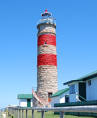
Cape Moreton Light, also listed as North Point Range Rear Light, is a heritage-listed active lighthouse located on Cape Moreton, a rocky headland located at the north eastern tip of Moreton Island, a large sand island on the eastern side of Moreton Bay, on the coast of South East Queensland, Australia. It marks the northern entrance to Moreton Bay and Brisbane and also serves as the rear light for the North Point Range. With its two distinctive red bands, it also serves as a daymark. It is the oldest lighthouse in Queensland, and the only one to be built by the New South Wales Government before the separation of Queensland, which took place in 1859. It is also the only lighthouse in Queensland to be built of stone.

<span class="mw-page-title-main">Cape Cleveland Light</span> Lighthouse in Queensland, Australia

Cape Cleveland Light is an active heritage-listed lighthouse located on the northern tip of Cape Cleveland, a promontory projecting into the Coral Sea west of Cleveland Bay in the locality of Cape Cleveland about 40 kilometres (25 mi) east of Townsville, Queensland, Australia. The lighthouse marks the northern point of the Cape, and the entrance to Cleveland Bay.

<span class="mw-page-title-main">Cleveland Point Light</span> Lighthouse in Australia

Cleveland Point Light, also known as Point Cleveland Light, is a lighthouse located on the north-eastern tip of Cleveland Point, at Cleveland, Redland City, Queensland, Australia. It overlooks Moreton Bay to the east and Raby Bay to the west. The old lighthouse was established in 1864-1865 as a wooden hexagonal tower. It is one of only two surviving lighthouses of this form, the other being Old Burnett Heads Light. A newer light, constructed of a concrete post, replaced it in 1976, and the old lighthouse was relocated a short distance away, where it stands today. The newer light was removed in 2009.

<span class="mw-page-title-main">Dent Island Light</span> Lighthouse

Dent Island Light is an active lighthouse on Dent Island, a small island off the coast of Queensland, Australia, part of the Whitsunday Group of the Whitsunday Islands. Located on the southwest tip of the island, the light guides ships navigating the Whitsunday Passage, between Whitsunday Island and the islands to the west, and marks the Dent Island Passage.

<span class="mw-page-title-main">Low Isles Light</span> Lighthouse

Low Isles Light, also known as Low Islets Light or Low Island Light, is an active lighthouse located on Low Island, a coral cay which together with Woody Island forms the Low Isles group, about 13 kilometres (8.1 mi) northeast of Port Douglas, Queensland, Australia. The island is situated on the western edge of the main shipping channel into the harbour of Port Douglas, and it marks the entrance to the channel. Built in 1878, it was the first lighthouse in Far North Queensland and more specifically the first to light the Inner Passage of the Great Barrier Reef. Its construction is typical to Queensland lighthouses of the time, timber frame clad with galvanized iron, and it is the fourth lighthouse of this type constructed in Queensland, though it is the first of them to use portholes.

<span class="mw-page-title-main">Caloundra Lighthouses</span> Historic site in Queensland, Australia

Caloundra Lighthouses are a heritage-listed pair of lighthouses at 3 Canberra Terrace, near Arthur Street, Kings Beach, Caloundra, Sunshine Coast Region, Queensland, Australia. The first, known as the Old Caloundra Light, was designed by Francis Drummond Greville Stanley and built in 1896; the second, New Caloundra Light, was built in 1968. They were added to the Queensland Heritage Register on 5 February 2010.

References

  • Rowlett, Russ. "Lighthouses of Australia: Southern Queensland". The Lighthouse Directory. University of North Carolina at Chapel Hill . Retrieved 14 November 2010.
  • Searle, Garry. "List of Lighthouses - Queensland". Lighthouses of Australia. SeaSide Lights.
  • "The New Caloundra Lighthouse". Lighthouses of Queensland. Lighthouses of Australia Inc.
  • "Caloundra Lighthouses (entry 602746)". Queensland Heritage Register . Queensland Heritage Council. Retrieved 13 July 2015.
  • "Lytton Hill (listing QLD601366)". Australia Heritage Places Inventory. Department of Sustainability, Environment, Water, Population and Communities.
  • "Minutes - Caloundra Lighthouses". sites.google.com. Retrieved 9 April 2011.