
Gheebulum Kunungai is a national park which covers 98% of Moreton Island (Mulgumpin) in Queensland, Australia, 40 km northeast of center of the Brisbane. Its eastern part of he City of Brisbane. It has three main townships, Bulwer, Cowan Cowan and Kooringal.
Moreton Island (Mulgumpin) is an island on the eastern side of Moreton Bay on the coast of South East Queensland, Australia. The Coral Sea lies on the east coast of the island. Moreton Island lies 58 kilometres (36 mi) northeast of the Queensland capital, Brisbane. 98% of the island is contained within a national park and a popular destination for day trippers, four wheel driving, camping, recreational angling and whale watching and a 75-minute ferry ride from Brisbane. It is the third largest sand island in the world. Together with Fraser Island, Moreton Island forms the largest sand structure in the world. It was the traditional country of the Ngugi before settlement.

Cape Moreton is a rocky headland at the north eastern tip of Moreton Island in South East Queensland, Australia. The surrounding area is part of the Moreton Island National Park. Flinders Reef is 5 kilometres (3 mi) north-west of Cape Moreton.

Moreton Island is the largest locality on the island Moreton Island within the City of Brisbane, Queensland, Australia. In the 2021 census, Moreton Island had a population of 180 people.

South Passage is channel between the South Pacific Ocean and Moreton Bay. The other entrances to the bay are the North Passage or North Entrance and Jumpinpin Channel in the south.
The Old Burnett Heads Light is an inactive lighthouse which used to be located on the south side of the Burnett River entrance, in Burnett Heads, Queensland, Australia. It was relocated to the Burnett Heads Lighthouse Holiday Park. It is one of only two lighthouse surviving to be constructed of timber frame clad with weatherboards, the other being the original Cleveland Point Light.

Bustard Head Light is an active lighthouse located on the southeast tip of Bustard Head, a headland, about 20 kilometres (12 mi) northwest of Seventeen Seventy, in the Australian state of Queensland, within the Eurimbula National Park and locality of Eurimbula. Built in 1868, it is the second-oldest lightstation in the state, following Cape Moreton Light, and the first to be built in Queensland after its formation in 1859. It is also one of the first in Australia to be constructed using bolted prefabricated segments of cast iron, and one of only two such lighthouses in Queensland, the other being its sibling, Sandy Cape Light. It serves as the central relay for Dent Island Light, Pine Islet Light and Lady Elliot Island Light and as the radio check post for Cape Capricorn Light, Sandy Cape Light and Double Island Point Light.

Sandy Cape Light is a heritage-listed active lighthouse located on Sandy Cape, the most northern point on K'gari, Queensland, Australia. It stands about 6 kilometres (3.7 mi) southwest of the northeastern tip of the island. It is the tallest lighthouse in Queensland. Built in 1870, it is the second major lighthouse to be built in Queensland after its formation in 1859. It is one of the first lighthouses in Australia to be constructed using bolted prefabricated segments of cast iron, and one of only two such lighthouses in Queensland, the other being its sibling, Bustard Head Light.

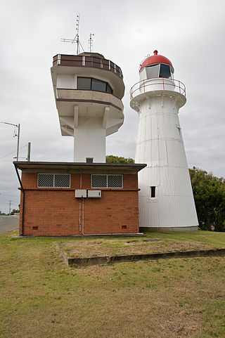
Point Cartwright Light is an active lighthouse located on Point Cartwright, a point near the mouth of the Mooloolah River, in Mooloolaba, Queensland, Australia. It marks the entrance to the North West Channel, a deep water channel into Moreton Bay and the Port of Brisbane, and provides guidance into the Mooloolaba Harbour.

Cape Bowling Green Light is an active lighthouse on Cape Bowling Green, a long headland ending in a long low sandspit, about 30 kilometres (19 mi) from Ayr, Queensland, Australia. The lighthouse is at the end of the headland, near the base of the sandspit. The first lighthouse at the location, established in 1874, was moved multiple times. It was prefabricated in Brisbane, shipped to the location, moved twice due to coastal erosion and finally transferred for display at the Australian National Maritime Museum at Darling Harbour in Sydney.
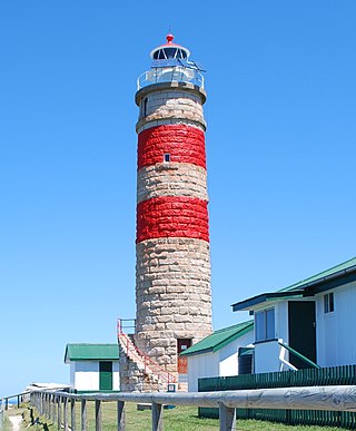
Cape Moreton Light, also listed as North Point Range Rear Light, is a heritage-listed active lighthouse located on Cape Moreton, a rocky headland located at the north eastern tip of Moreton Island, a large sand island on the eastern side of Moreton Bay, on the coast of South East Queensland, Australia. It marks the northern entrance to Moreton Bay and Brisbane and also serves as the rear light for the North Point Range. With its two distinctive red bands, it also serves as a daymark. It is the oldest lighthouse in Queensland, and the only one to be built by the New South Wales Government before the separation of Queensland, which took place in 1859. It is also the only lighthouse in Queensland to be built of stone.

Cape Cleveland Light is an active heritage-listed lighthouse located on the northern tip of Cape Cleveland, a promontory projecting into the Coral Sea west of Cleveland Bay in the locality of Cape Cleveland about 40 kilometres (25 mi) east of Townsville, Queensland, Australia. The lighthouse marks the northern point of the Cape, and the entrance to Cleveland Bay.

Cleveland Point Light, also known as Point Cleveland Light, is a lighthouse located on the north-eastern tip of Cleveland Point, at Cleveland, Redland City, Queensland, Australia. It overlooks Moreton Bay to the east and Raby Bay to the west. The old lighthouse was established in 1864-1865 as a wooden hexagonal tower. It is one of only two surviving lighthouses of this form, the other being Old Burnett Heads Light. A newer light, constructed of a concrete post, replaced it in 1976, and the old lighthouse was relocated a short distance away, where it stands today. The newer light was removed in 2009.
Comboyuro Point Light, which was also known later as Comboyuro Light, was located on Comboyuro Point, at the northwestern tip of Moreton Island. It is one of the Moreton Island lighthouses.
North Point Light, also known as North Point Hummock Light, was located on North Point, the most northern point on Moreton Island. North Point Light was constructed in the early 1860s, carrying a large kerosene burner with a reflector.

Cowan Cowan Point Light, was also known as Cowan Cowan Light or Cowan Point Light, was located on Cowan Cowan Point, on the western shore of Moreton Island, Queensland, Australia.

Fort Cowan Cowan is a heritage-listed World War II fortification at 30 Jessie Wadsworth Street, Moreton Island, City of Brisbane, Queensland, Australia. It is also known as RAN 3 Cowan Cowan, Fort Cowan and Cowan Cowan Battery. It was added to the Queensland Heritage Register on 1 October 2007.

Signal Station, Moreton Island is a heritage-listed signal station at 25 Dorothy Newnham Street, Moreton Island, City of Brisbane, Queensland, Australia. It was built in the 1930s. It is also known as Former Navy Signal Station Fort Cowan. It was added to the Queensland Heritage Register on 1 February 1995.
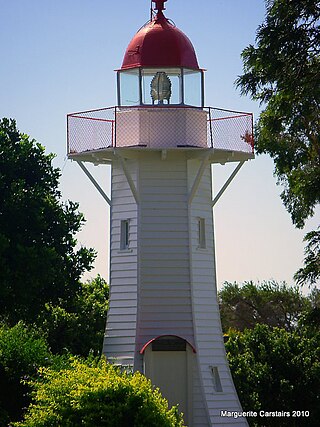
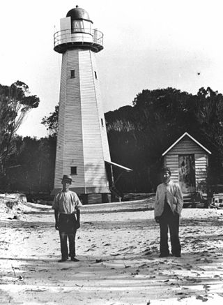
Caloundra Lighthouses are a heritage-listed pair of lighthouses at 3 Canberra Terrace, near Arthur Street, Kings Beach, Caloundra, Sunshine Coast Region, Queensland, Australia. The first, known as the Old Caloundra Light, was designed by Francis Drummond Greville Stanley and built in 1896; the second, New Caloundra Light, was built in 1968. They were added to the Queensland Heritage Register on 5 February 2010.


