Cape Don Light

Last updated

Cape Don Light
Cape Don Lighthouse.jpg
Cape Don Lightstation. One of the keeper's cottages visible to the right.
Cape Don Light
Location Cobourg Peninsula
Northern Territory
Australia
Coordinates 11°18′28.36″S131°45′54.56″E / 11.3078778°S 131.7651556°E / -11.3078778; 131.7651556 Coordinates: 11°18′28.36″S131°45′54.56″E / 11.3078778°S 131.7651556°E / -11.3078778; 131.7651556
Tower
Constructed1917
Constructionreinforced concrete tower
Height118 feet (36 m)
Shapecylindrical tower on octagonal prism basement with balcony and lantern
Markingsunpainted tower, white lantern
Power sourcesolar power  OOjs UI icon edit-ltr-progressive.svg
Light
Automated1983
Focal height163 feet (50 m)
Lens Chance Brothers 3rd order Fresnel lens [1]
Intensity260,000  cd
Range22 nautical miles (41 km)
Characteristic Fl W 10s.

Cape Don Light is an active lighthouse located on Cape Don, at the tip of the Cobourg Peninsula, Northern Territory, Australia, in Garig Gunak Barlu National Park, marking the entrance to the Dundas Strait. It is Australia's northernmost traditional lighthouse. [2] The station served on the important route to Darwin, between the peninsula and Melville Island. [3] The tower was constructed in 1915–1917, during the "Golden Age of Australian Lighthouses" (1913–1920), [4] and the tower was manned until 1983. [5] During the entire period that the tower was manned it also maintained meteorological records which were well placed to assist in cyclone development tracking. [6] The complex consists of the lighthouse, three residences and ancillary buildings. [5]

Contents

Cape Don was named by Phillip Parker King in 1818, as a compliment to General Sir George Don, the Lieutenant-Governor of Gibraltar. [3]

History

Plans for the site copied in 1912 from 1908 plans Cape Don - Plan of sites for a lighthouse, 1912.jpg
Plans for the site copied in 1912 from 1908 plans
Cape Don Light on the year in which construction finished, 1917 Cape Don Light 1917.jpg
Cape Don Light on the year in which construction finished, 1917
Plans for the optical apparatus Cape Don Light - apparatus drawing plan, 1915.jpg
Plans for the optical apparatus

The Northern Territory was transferred from the government of South Australia to the federal parliament in 1911. [7] The Commonwealth Lighthouse Service was officially formed on 1 July 1915, [4] and one of the first actions of the service was to realise the need for a lighthouse on the Cobourg Peninsula, as the passage between the peninsula and Melville Island was an important route to Darwin. [3] Construction of the tower was the largest project undertaken by the Commonwealth Lighthouse Service during the "Golden Age of Australian Lighthouses" (1913–1920). [4]

Work on the tower began in May 1915. An iron structure was deemed unsuitable due to the tropical conditions, and the local ironstone was not suitable for concrete, so materials had to be shipped from Melbourne. However, landing conditions at the site meant the closest location for landing the materials was about 3 miles (5 km) to the east, at Christies Bay. [5] A jetty and a tramway were constructed, and the materials were drawn by horses from the landing location. The climate and the grade meant only two round trips could be made each day, and in addition, construction could only be carried out on the dry season, from April to November. As a result, construction took three years, completing in June 1917. [3] Though the lantern was installed and ready to be lit, an earthquake hit the tower in August 1917. Though the structure was not damaged, 12 kilograms (26 lb) of mercury were lost from the mercury-bearing pedestal bath. [3] The lighthouse was finally officially lit on 15 September 1917. [5]

The tower original light source was a 55-millimetre (2.2 in) [5] vapourised kerosene incandescent mantle, with an intensity of 150,000  cd and a visible range of 23 nautical miles (43 km; 26 mi). [3] The original lens was a Chance Brothers 3rd order [1] 500-millimetre (20 in) [5] dioptric [3] fresnel lens. The apparatus was a rotating pedestal floating in a mercury bath, operated by a clockwork mechanism with descending weights, which only had to be rewound once every twelve hours. [3]

In the Second World War, a radar station was installed near the complex. [6]

In the early 1970s, the tower was electrified, with power coming from diesel generators. [3] The light source was converted to a 120-volt tungsten-halogen lamp. [5]

In 1983 the light was automated and the station was demanned. [3] The apparatus installed consists of four vertical panels, each consisting of four 300-millimetre (12 in) rear surfaced parabolic reflectors. The lamps are 12-volt 36-watt quartz halogen lamps, electrically connected in pairs 180° apart. The apparatus is installed on a gear-less pedestal, rotating three times per minute, [5] showing a light characteristic of one white flash every 10 seconds (Fl.W. 10s). [8] The light intensity is 260,000 cd [5] and the light is visible for 22 nautical miles (41 km; 25 mi). [5] The light is solar powered, and it was the first of its kind in Australia. [3] At the same time the cottages were handed over to the Northern Territory Conservation Commission. [3]

In 2005, the original lens and its rotating apparatus were discovered in storage and donated to the Queensland Maritime Museum in Brisbane. [2]

Structures

Tower plans and sections, 1915 Cape Don Light - sections and plans, 1915.jpg
Tower plans and sections, 1915

The tower is 28 metres (92 ft) from the ground to the platform. [9] The base is cylindrical, with an octagonal base. On top of the platform is the original 10-foot, 8-inch (3.25 m) Chance Brothers lantern. [5]

Accommodations at the site consist of three lighthouse keeper's cottages, constructed from concrete blocks, set on high blocks with reinforced concrete beams. The cottages have timber floors and wide timber verandahs, enclosed with pivoting storm screens. The original roofing was corrugated galvanised iron, replaced by corrugated asbestos cement roofing in one of the houses. Originally, a breezeway divided the houses into two sections, one comprising three rooms and one comprising two larger rooms, with a corridor between them leading to the double doors to the verandah. The building has been altered, and the original breezeway has been converted to a living area. [5]

Other structures in the complex include small concrete block storage sheds, adjacent to each of the houses, block work sheds around the tower, and some galvanised iron sheds including a powerhouse, a maintenance workshop and a store. At the northern boundary of the complex lies a bore and mill, and an abandoned garden next to it. The original raised water tank is at the center of the complex. [5]

The path of the original tramway, from the complex to Christies Bay, is still visible, and the narrow gauge tramway itself is partially intact, except towards the bay. At the end of the tramway is a causeway, approximately 90 metres (300 ft) long and 4 metres (13 ft) wide, going through a mangrove swamp into the bay. At its end is a shelter. The jetty no longer exists, though the upright tramway rails which supported it still exist. [5]

Site operation

The light is operated by the Australian Maritime Safety Authority, [2] while the site is managed by the Garig Gunak Barlu National Park authorities.

Visiting

The Cape Don Lightstation, 2007 Cape Don lightstation 20070508 6221.jpg
The Cape Don Lightstation, 2007

The location is accessible for 4WD car only in the dry season (May–October) and requires permits and paying a fee. [10] The site is also accessible by air and boat. The tower is closed to the public. [2] The head lighthouse keeper's house has been converted to a fishing lodge and is available for overnight accommodations. [11]

See also

Notes

  1. 1 2 According to RNE229 and Lighthouses of Australia Inc. Rowlett says a 1st order lens.
  2. 1 2 3 4 Rowlett.
  3. 1 2 3 4 5 6 7 8 9 10 11 12 Lighthouses of Australia Inc.
  4. 1 2 3 Komesaroff 1977.
  5. 1 2 3 4 5 6 7 8 9 10 11 12 13 14 RNE229.
  6. 1 2 NT22.
  7. Yearbook, p. 103.
  8. List of Lights
  9. According to Lighthouses of Australia Inc. RNE229 says "36m", which List of Lights lists as the total focal height.
  10. Garig Gunak Barlu National Park.
  11. Cape Don Fishing Lodge.

Related Research Articles

Garig Gunak Barlu is a protected area in the Northern Territory of Australia on the Cobourg Peninsula and some adjoining waters about 216 kilometres (134 mi) north-east of the territory capital of Darwin.

Cobourg Peninsula

The Cobourg Peninsula is located 350 kilometres (217 mi) east of Darwin in the Northern Territory, Australia. It is deeply indented with coves and bays, covers a land area of about 2,100 square kilometres (811 sq mi), and is virtually uninhabited with a population ranging from about 20 to 30 in five family outstations, but without any notable settlement or village. It is separated from Croker Island in the east by Bowen Strait, which is 2.5 kilometres wide in the south and up to 7 kilometres in the north, and 8.5 kilometres long. In the west, it is separated from Melville Island by Dundas Strait. From Cape Don, the western point of the peninsula, to Soldier Point in the east of Melville Island, the distance is 28 kilometres (17 mi). In the north is the Arafura Sea, and in the south the Van Diemen Gulf. The highest elevation is Mount Roe in the south with an altitude of 160 metres (525 ft).

Richmond River Light Lighthouse in New South Wales, Australia

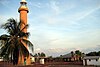
Richmond River Light, also known as Ballina Head Light and Ballina Light, is an active lighthouse located at Ballina Head, a headland in Ballina, New South Wales, Australia. The headland is at the northern side of the entrance to the Richmond River. It used to serve to guide ships into the river port and is used also serves as a leading light into the river, together with a steamer's masthead lantern with a 200 mm lens which is raised on a wooden structure 30 metres (98 ft) from it.

Cape Byron Light Lighthouse in New South Wales, Australia

Cape Byron Light, also called Cape Byron Lightstation, is an active heritage-listed lighthouse and now interpretative centre, interpretative space, maritime museum, administration office, retail building, accommodation, tourist attraction and visitor attraction located at Lighthouse Road, Byron Bay, Cape Byron, Byron Shire, New South Wales, Australia. It was designed by Charles Harding and Cecil W. Darley and built from 1899 to 1901 by Messrs Mitchell & King. It is also known as Cape Byron Lightstation, Byron Bay Lighthouse, Cape Byron Headlan and Cape Byron Headland Reserve. The property is owned by NSW National Parks & Wildlife Service.

Crowdy Head Light Lighthouse in New South Wales, Australia

Crowdy Head Light is an active lighthouse located at Crowdy Head, a headland between Forster and Port Macquarie, New South Wales, Australia. It is registered with the Register of the National Estate.

Fingal Head Light Lighthouse in New South Wales, Australia

Fingal Head Light is an active lighthouse located at Fingal Head, New South Wales, Australia, a headland about 5 kilometres (3.1 mi) south of Point Danger, which marks the Queensland border.

Norah Head Light Lighthouse in New South Wales, Australia

Norah Head Light is an active lighthouse located at Norah Head, a headland on the Central Coast, New South Wales, Australia, close to Toukley. It is the last lighthouse of the James Barnet style to be built, and the last staffed lighthouse constructed in New South Wales.

Warden Head Light Lighthouse in New South Wales, Australia

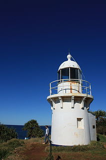
Warden Head Light, also known as Ulladulla Lighthouse, is an active lighthouse on Warden Head, a headland south of Ulladulla, New South Wales, Australia, guarding the entrance to the Port of Ulladulla. It is one of only two wrought iron lighthouses in New South Wales, the other being its sibling, Wollongong Breakwater Lighthouse. It is also notable for two relocations: the tower was constructed in 1873 on the Ulladulla Breakwater, and relocated in 1889 to its current location. Its keeper's house was relocated to a different location in the 1920s.

Cape Fourcroy Light is an active lighthouse located on Cape Fourcroy, on the southwestern tip of Bathurst Island, Northern Territory, Australia. The lighthouse marks the beginning of the route from the Timor Sea to Darwin.

Cape Hotham Light Lighthouse in Northern Territory, Australia

Cape Hotham Light is an active lighthouse in the Northern Territory of Australia located on Cape Hotham on the coastline of the Van Diemen Gulf about 80 kilometres (50 mi) northeast of the territory capital of Darwin, The lighthouse marks the entrance to Clarence Strait, the eastern approach to Darwin.

Emery Point Light Lighthouse in Northern Territory, Australia

Emery Point Light is an active lighthouse located at Larrakeyah Barracks, the main base for the Australian Defence Force in Northern Territory, Australia, at the entrance to Port Darwin. It was the second lighthouse to be built in Port Darwin. It was the only navigational aid to remain functional in the path of Cyclone Tracy.

Point Charles Light Lighthouse in Northern Territory, Australia

Point Charles Light, known officially as the Charles Point Lighthouse, is an active lighthouse located on a headland at the northern end of the Cox Peninsula, 21 kilometres (13 mi) northwest of Port Darwin, Northern Territory, Australia. Established in 1893, it is the oldest lighthouse in the Northern Territory.

Booby Island Light Lighthouse

Booby Island Light is an active heritage-listed lighthouse located on Booby Island in the Shire of Torres, near the tip of Cape York Peninsula, west of Prince of Wales Island, within the Endeavour Strait, Queensland, Australia. It marks the western entrance to the navigation channel through the Torres Strait. It was the last of the major lights to be constructed along the Queensland coast.

Fitzroy Island Light is an inactive lighthouse on Fitzroy Island, a continental island 29 kilometres (18 mi) southeast of Cairns, Queensland, Australia. It was only active between 1973 and 1992 but, together with Little Fitzroy Island Light, there has been a light station in the area since 1929. Fitzroy Island lighthouse now serves as a visitor centre for the Fitzroy Island National Park.

Cape Moreton Light Lighthouse in Queensland, Australia

Cape Moreton Light, also listed as North Point Range Rear Light, is a heritage-listed active lighthouse located on Cape Moreton, a rocky headland located at the north eastern tip of Moreton Island, a large sand island on the eastern side of Moreton Bay, on the coast of South East Queensland, Australia. It marks the northern entrance to Moreton Bay and Brisbane and also serves as the rear light for the North Point Range. With its two distinctive red bands, it also serves as a daymark. It is the oldest lighthouse in Queensland, and the only one to be built by the New South Wales Government before the separation of Queensland, which took place in 1859. It is also the only lighthouse in Queensland to be built of stone.

Cleveland Point Light Lighthouse in Australia

Cleveland Point Light, also known as Point Cleveland Light, is a lighthouse located on the north-eastern tip of Cleveland Point, at Cleveland, Redland City, Queensland, Australia. It overlooks Moreton Bay to the east and Raby Bay to the west. The old lighthouse was established in 1864-1865 as a wooden hexagonal tower. It is one of only two surviving lighthouses of this form, the other being Old Burnett Heads Light. A newer light, constructed of a concrete post, replaced it in 1976, and the old lighthouse was relocated a short distance away, where it stands today. The newer light was removed in 2009.

Double Island Point Light Lighthouse

Double Island Point Light is an active lighthouse located at the summit of Double Island Point, a coastal headland within the Cooloola section of the Great Sandy National Park. It is located at the southern end of Wide Bay, 70 kilometres (43 mi) north of Noosa Heads, Queensland, Australia.

Eborac Island Light Lighthouse

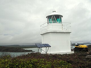
Eborac Island Light is an active lighthouse on Eborac Island, a small rocky island in the Adolphus Channel just off Cape York, the northern tip of Cape York Peninsula, Far North Queensland, Australia. It guides ships into the coastal channel inside the Great Barrier Reef. A concrete structure was built in 1921 and converted to solar power in 1990. It was replaced with a fiberglass structure in 2012.

Wharton Reef Light is an inactive lighthouse which used to be located on Wharton Reef in Princess Charlotte Bay off the Cape York Peninsula, Queensland, Australia. When it was deactivated in 1990 it was donated to the Townsville Maritime Museum and it is now on display near the museum. It is the only survivor of a series of twenty automatic lighthouses installed in Queensland during the "Golden Age of Australian Lighthouses" from 1913 to the early 1920s.

References