Lady Elliot Island

Last updated

Lady Elliot Island
Lady Elliot Island.jpg
Lady Elliot Island as seen from the air
Australia Queensland relief location map.jpg
Red pog.svg
Lady Elliot Island
Australia relief map.jpg
Red pog.svg
Lady Elliot Island
Geography
Location Coral Sea
Coordinates 24°07′S152°43′E / 24.117°S 152.717°E / -24.117; 152.717
Archipelago Capricorn and Bunker Group
Area0.69 km2 (0.27 sq mi)
Administration
Australia
Region Central Queensland
An image of the island and nearby coral reefs taken with the Seaview SVII camera Lady Elliot Island SVII.jpg
An image of the island and nearby coral reefs taken with the Seaview SVII camera

Lady Elliot Island is the southernmost coral cay of the Great Barrier Reef, Australia. The island lies 46 nautical miles (85 km; 53 mi) north-east of Bundaberg and covers an area of approximately 45 hectares (110 acres). It is part of the Capricorn and Bunker Group of islands and is owned by the Commonwealth of Australia. The island is home to a small eco resort and an airstrip, which is serviced daily by flights from Bundaberg, Hervey Bay, Brisbane and the Gold Coast.

Contents

Lady Elliot Island is located within the 'Green Zone' of the Great Barrier Reef Marine Park, which is the highest possible classification designated by the Great Barrier Reef Marine Park Authority. Marine National Park Green Zones protect the biodiversity within the Great Barrier Reef Marine Park by protecting important breeding and nursery areas such as seagrass beds, mangrove communities, deepwater shoals and reefs. [1]

The island is particularly renowned for its scuba diving and snorkelling, as its location far offshore at the southern end of the Great Barrier Reef results in excellent water clarity.

Flora

Old Lighthouse and underwater reef Lady Elliot Island Lighthouse and Coral Reef.jpg
Old Lighthouse and underwater reef

The island is a vegetated shingle cay, which is uncommon. [2] Typically these type of cays are too narrow to retain fresh water or too mobile for vegetation to take hold. Pisonia grandis grows on the island. [3]

Fauna

The waters surrounding the island are particularly rich in sealife because of a total ban on fishing or taking anything from the surrounding waters. [4] Manta rays are abundant, attracted to the plankton around the island. The speckled carpetshark is often observed in the waters around the island. [5] It is the only known locality home to the Lady Elliot Shrimp Goby ( Tomiyamichthys elliotensis ) which was described in 2023. [6]

Turtles

The Great Barrier Reef is one of the most important sea turtle habitats in the world, with Lady Elliot Island being a key part of that habitat. Every year between November and March the green and loggerhead turtles lumber up the same beach on which they were born more than 50 years ago. These turtles nest on Lady Elliot Island up to nine times in a season, laying between 80 and 120 eggs per clutch. About eight to twelve weeks later, [7] young hatchlings leave their nests and head towards the ocean (January to April).

Whales

Lady Elliot Island is just north of Hervey Bay, a popular humpback whale resting ground along their migration route. Whales are common in the waters around the island in the winter and early spring from June to October. [4] Regular sightings occur on the flights to the island, and while snorkelling and diving from boats and from the island's beaches. Almost daily during the season, whale songs can be heard under the water while swimming around the island.

Birds

Lady Elliot Island has one of the highest seabird diversity of any island within the Great Barrier Reef. [8] The Capricorn silvereye, a small bird endemic to the southern Great Barrier Reef, is found on the island, which is also home to the buff-banded rail. It is an important seabird nesting site. [7] The cay is a haven for over fifty species of tropical seabirds and wading birds. Over 100,000 birds nest on Lady Elliot Island during summer breeding season.

Black noddies on Lady Elliot Island Noddies on Lady Elliot Island.jpg
Black noddies on Lady Elliot Island

Seabirds that nest on Lady Elliot Island include:

History

Origin

Lady Elliot Island first appeared above sea level around 1500 BC as a coral rubble spit. It developed into a mature coral cay over the next 3,000 years. Lady Elliot had endured because bird droppings have hardened together with beach sediments into beachrock. [10] The existence of concentric shingle ridges across the island provides evidence of its formation by progradation over several millennia as deposits were laid down during episodic storms. [2]

First commercial venture

In 1805, first commercial venture on Lady Elliot Island was the collecting of bêche-de-mer . These animals were removed from the shallow water, dried and then smoked before being exported to South-East Asia. [11] The industry petered out when there were no more sea cucumbers. [12] [13]

British discovery

In 1816, the island was officially discovered and named by Captain Thomas Stewart aboard the vessel Lady Elliot . [14] on the way to Sydney in 1816. [15] [16] The Lady Elliot was a 353-tonne vessel that was built in Bengal and registered in Calcutta, India. [17] On the return journey from Sydney, it was wrecked on a reef south of Cardwell in North Queensland, and that reef is called Lady Elliot Reef. [18]

The ship was probably named after Anna Maria Elliot, the wife of Gilbert Elliot-Murray-Kynynmound, 1st Earl of Minto, a Scottish politician who was Governor-General of India between 1807 and 1813. Anna Maria (later Lady Elliot) was the daughter of Sir George Amyand, 1st Baronet. [19] An alternative story suggests that it was named after Margaret, wife of Gilbert's brother, Hugh Elliot, a diplomat and Governor of Madras from September 1814 to June 1820. [20] However, Hugh Elliot's wife was not a "Lady", as he was a career diplomat, was not knighted and did not inherit any titles of nobility.

Mining for guano

In 1863, Mr J. Askunas won tender from the Queensland Government to mine the island for guano for 300 pounds per annum for 10 years. The lease was transferred to Dr W.I. Crowther of Hobart on 23 August 1864. Dr Crowther mined the island until the end of 1873. The guano was mined by Chinese and Malay workers and sent to mainland Australia and New Zealand. [21] Over this period virtually all the trees were removed, as well as 3 feet of top soil and guano. In 1874, the guano mining ceased, but the damage to the vegetation of the island was absolute. It was not until 1966 that a revegetation program was undertaken by lighthouse staff. Their efforts were quickly rewarded, with the island re-emerging as a haven for all types of seabirds.

Lighthouse

The old Lady Elliot Island Light Old Lady Elliot Lighthouse.jpg
The old Lady Elliot Island Light

The first lighthouse to be built on the island was constructed in 1866. [7] It was the third lighthouse built in Queensland and the first to be built offshore on the Great Barrier Reef. [8] The original structure was destroyed by a cyclone six years later. In 1873, another lighthouse was constructed, Lady Elliot Island Light. The lighthouse is on the National Heritage list because it is a timber-framed construction with a cast iron cladding, which was premade in England and shipped to the island in pieces. This lighthouse is 15 metres (49 ft) tall and shone out approximately 30 kilometres (19 mi) to sea. The old lighthouse was used continuously until 1995 but became too short for the surrounding vegetation, which was interrupting the beam of light. At this time the Australian Maritime Safety Authority built a new light tower. It is 21 metres (69 ft) tall and its six light beams shine 40 kilometres (25 mi) out to sea. It is solar powered, fully automated and runs continuously. The original lighthouse was placed on the Commonwealth Heritage List in 2004. The Lady Elliot Island Lightstation Heritage Management Plan was developed by the Great Barrier Reef Marine Park Authority (GBRMPA) in March 2012 to protect, conserve and manage the Commonwealth Heritage values of the Lady Elliot Island lighthouse.

Airstrip and resort

Australia lei map.svg

In 1969, Don Adams (who later went on to found Seabird Aviation) built an airstrip and accommodation on the island, and was granted a tourist recreation lease by the Australian Government. In 1977, Don Adams sold the lease to Barrier Reef Airways. In 1984, the Australian Government called for tenders to construct a low-key resort on that island. The first owner of the resort lease was John and Judy French, with the resort opening in 1985.[ citation needed ] In 1992, the resort lease changed hands and was sold to Bevan Whittaker. Guided activities on the island include reef walking, glass bottom boat/guided snorkel tours, island history tours, bird watching tours and turtle treks in season.

In 2005, the original 20-year resort lease came up for renewal and was put to tender. The tender was won by three Gold Coast businessmen—Peter Gash, Grant Kenny and Michael Kyle. A new lease was granted for a 10-year period, with two options each for a further term of ten years. Since the change of lessee, a program to progressively renovate the island's facilities and make them more ecologically friendly has been implemented. [22] The Lady Elliot Island Eco Resort Management team is dedicated to the preservation of the natural environment of the Great Barrier Reef, with their goal to work in harmony with nature for the benefit of future generations.

Lady Elliot Island Eco Resort has introduced a range of environmental best-practice measures, including construction of a hybrid solar power station to reduce energy consumption and carbon emissions. Lady Elliot Island Eco Resort has also achieved the highest level of ECO Certification program 'ECO Certified – Advanced Ecotourism' with Ecotourism Australia. Tourist services to the island are provided by Seair Pacific.

Administration

Lady Elliot Island is inside the Great Barrier Reef Marine Park, which is maintained by the Great Barrier Reef Marine Park Authority. The island is also maintained by Lady Elliot Island Eco Resort.

Climate

Lady Elliot Island has a tropical savanna climate (Aw).

Climate data for Lady Elliot Island
MonthJanFebMarAprMayJunJulAugSepOctNovDecYear
Record high °C (°F)33.9
(93.0)
33.7
(92.7)
33.0
(91.4)
31.2
(88.2)
28.8
(83.8)
27.4
(81.3)
26.4
(79.5)
28.1
(82.6)
28.4
(83.1)
29.5
(85.1)
31.3
(88.3)
32.9
(91.2)
33.9
(93.0)
Mean daily maximum °C (°F)29.9
(85.8)
29.7
(85.5)
28.9
(84.0)
27.1
(80.8)
24.5
(76.1)
22.4
(72.3)
21.8
(71.2)
22.7
(72.9)
24.7
(76.5)
26.3
(79.3)
27.9
(82.2)
29.1
(84.4)
26.3
(79.3)
Mean daily minimum °C (°F)24.4
(75.9)
24.4
(75.9)
23.7
(74.7)
22.0
(71.6)
19.5
(67.1)
17.7
(63.9)
16.8
(62.2)
17.3
(63.1)
19.1
(66.4)
20.5
(68.9)
22.1
(71.8)
23.4
(74.1)
20.9
(69.6)
Record low °C (°F)16.4
(61.5)
17.4
(63.3)
16.7
(62.1)
13.7
(56.7)
11.9
(53.4)
7.9
(46.2)
8.1
(46.6)
6.8
(44.2)
9.5
(49.1)
12.4
(54.3)
14.9
(58.8)
16.2
(61.2)
6.8
(44.2)
Average rainfall mm (inches)84.0
(3.31)
130.6
(5.14)
93.7
(3.69)
88.4
(3.48)
111.3
(4.38)
87.7
(3.45)
69.1
(2.72)
46.4
(1.83)
42.1
(1.66)
52.6
(2.07)
48.2
(1.90)
101.9
(4.01)
956
(37.64)
Source: Australian Bureau of Meteorology [23]

See also

Related Research Articles

<span class="mw-page-title-main">Great Barrier Reef</span> Coral reef system in Queensland, Australia

The Great Barrier Reef is the world's largest coral reef system, composed of over 2,900 individual reefs and 900 islands stretching for over 2,300 kilometres (1,400 mi) over an area of approximately 344,400 square kilometres (133,000 sq mi). The reef is located in the Coral Sea, off the coast of Queensland, Australia, separated from the coast by a channel 160 kilometres (100 mi) wide in places and over 61 metres (200 ft) deep. The Great Barrier Reef can be seen from outer space and is the world's biggest single structure made by living organisms. This reef structure is composed of and built by billions of tiny organisms, known as coral polyps. It supports a wide diversity of life and was selected as a World Heritage Site in 1981. CNN labelled it one of the Seven Natural Wonders of the World in 1997. Australian World Heritage places included it in its list in 2007. The Queensland National Trust named it a state icon of Queensland in 2006.

<span class="mw-page-title-main">Great Barrier Reef Marine Park</span> Protected area in Queensland, Australia

The Great Barrier Reef Marine Park protects a large part of Australia's Great Barrier Reef from damaging activities. It is a vast multiple-use Marine Park which supports a wide range of uses, including commercial marine tourism, fishing, ports and shipping, recreation, scientific research and Indigenous traditional use. Fishing and the removal of artefacts or wildlife is strictly regulated, and commercial shipping traffic must stick to certain specific defined shipping routes that avoid the most sensitive areas of the park. The Great Barrier Reef is the largest and best known coral reef ecosystem in the world. Its reefs, almost 3000 in total, represent about 10 per cent of all the coral reef areas in the world. It supports an amazing variety of biodiversity, providing a home to thousands of coral and other invertebrate species, bony fish, sharks, rays, marine mammals, marine turtles, sea snakes, as well as algae and other marine plants.

<span class="mw-page-title-main">Capricornia Cays National Park</span> Protected area in Queensland, Australia

Capricornia Cays is both a national park and a scientific national park in Queensland (Australia), located 486 km and 472 km north of the state capital Brisbane respectively. Collectively they comprise 241 ha of coral cays.

<span class="mw-page-title-main">Fitzroy Island National Park</span> Protected area in Queensland, Australia

Fitzroy Island National Park is a gazetted protected area covering Fitzroy Island, in Far North Queensland, Queensland, Australia. Fitzroy Island, is a continental island located 22 kilometres (14 mi) east of Cairns on the mainland.

<span class="mw-page-title-main">Green Island National Park</span> Protected area in Queensland, Australia

Green Island National Park is a protected area declared over a small coral cay of Green Island, Cairns Region, Queensland, Australia. It is known to the local Gungganyji Aboriginal peoples as Dabuukji. The Gungganyji people used the island as an initiation ground.

<span class="mw-page-title-main">Heron Island (Queensland)</span> Coral cay in Queensland, Australia

Heron Island is a coral cay located near the Tropic of Capricorn in the southern Great Barrier Reef, 80 kilometres north-east of Gladstone, Queensland, Australia, and 460 km (290 mi) north-north-west of the state capital Brisbane. The island is situated on the leeward (western) side of Heron Reef, a fringing platform reef of significant biodiversity, supporting around 900 of the 1,500 fish species and 72% of the coral species found on the Great Barrier Reef. During the summer months Heron Island is also home to over 200,000 birds including Noddy Terns and Mutton Birds.

<span class="mw-page-title-main">North West Island</span> Island in Queensland, Australia

North West Island is a coral cay in the southern Great Barrier Reef, located 75 kilometres northeast of Gladstone, Queensland. North West Island forms part of Capricornia Cays National Park and with an area of 1.05 km2, the island is the second largest coral cay in the Great Barrier Reef. It is part of the Capricornia Cays Important Bird Area.

<span class="mw-page-title-main">Lady Musgrave Island</span> Protected area in Queensland, Australia

Lady Musgrave Island is a 14 hectares coral cay on Australia's Great Barrier Reef, with a 1,192 hectares surrounding reef. The island is the second southernmost island in the Great Barrier Reef chain of islands. The Island is named after Lady Lucinda Musgrave, the wife of Sir Anthony Musgrave, a colonial governor of Queensland.

<span class="mw-page-title-main">Environmental threats to the Great Barrier Reef</span>

The Great Barrier Reef is the world's largest reef systems, stretching along the East coast of Australia from the northern tip down at Cape York to the town of Bundaberg, is composed of roughly 2,900 individual reefs and 940 islands and cays that stretch for 2,300 kilometres (1,616 mi) and cover an area of approximately 344,400 square kilometres (133,000 sq mi). The reef is located in the Coral Sea, off the coast of Queensland in northeast Australia. A large part of the reef is protected by the Great Barrier Reef Marine Park.

<span class="mw-page-title-main">Raine Island</span> Small coral cay of Queensland, Australia

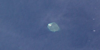
Raine Island is a vegetated coral cay 32 hectares in total area situated on the outer edges of the Great Barrier Reef off northeastern Australia. It lies approximately 620 km (390 mi) north-northwest of Cairns in Queensland, about 120 kilometres (75 mi) east-northeast of Cape Grenville on the Cape York Peninsula.

<span class="mw-page-title-main">Wreck Reefs</span> Reef in Australia

The Wreck Reefs are located in the southern part of the Coral Sea Islands approximately 450 kilometres (280 mi) east-north-east of Gladstone, Queensland, Australia.

<span class="mw-page-title-main">Capricorn and Bunker Group</span> Islands in Queensland, Australia

The islands and reefs of the Capricorn and Bunker Group are situated astride the Tropic of Capricorn at the southern end of the Great Barrier Reef, approximately 80 kilometres east of Gladstone, which is situated on the central coast of the Gladstone Region, Queensland, Australia.

Fairfax Islands is a pair of small coral cays, both of which have been used as a bombing range. They are located near the Tropic of Capricorn in the southern Great Barrier Reef, 113 kilometres (70 mi) due east of Gladstone, Queensland, Australia, and 405 km (252 mi) north of the state capital Brisbane.

Hoskyn Islands is a pair of small coral cays. They are located near the Tropic of Capricorn in the southern Great Barrier Reef, 107 km due east of Gladstone, Queensland, Australia, and 412 km north of the state capital Brisbane.

One Tree Island is a small coral cay. It is located near the Tropic of Capricorn in the southern Great Barrier Reef, 96 km due east nor east of Gladstone, Queensland, Australia, and 450 km north of the state capital Brisbane. The island is part of the Great Barrier Reef chain of islands, and is part of the Capricorn and Bunker Group of island and forms part of the Capricornia Cays National Park. It is also part of the Capricornia Cays Important Bird Area.

Tryon Island is a coral cay located in the southern Great Barrier Reef, 86 km northeast of Gladstone, Queensland, Australia, and 465 km north of the state capital Brisbane. The island is a protected area and forms part of Capricornia Cays National Park. It is part of the Capricornia Cays Important Bird Area. The cay covers an area of 0.21 square kilometres and is surrounded by a coral reef that is partially exposed at low-tide.

<span class="mw-page-title-main">Bramble Cay</span> Island in Queensland, Australia

Bramble Cay, also known as Maizab Kaur and Massaramcoer, is a small cay located at the northeastern edge of Australia and the Torres Strait Islands of Queensland and at the northern end of the Great Barrier Reef. Lying around 50 km (31 mi) north of Erub Island in the Gulf of Papua, it is the northernmost point of land of Australia and marks the end of the Great Barrier Reef.

<span class="mw-page-title-main">Coral Sea Reserves Ramsar Site</span> Marine nature reserve off Australia

The Coral Sea Reserves Ramsar Site comprises the 17,289 km2 of oceanic island and reef habitats within the former Coringa-Herald National Nature Reserve and the former Lihou Reef National Nature Reserve in the Australian Coral Sea Islands Territory.

<span class="mw-page-title-main">Lady Elliot Island Light</span> Lighthouse

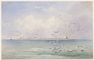
Lady Elliot Island Light is an active lighthouse located on Lady Elliot Island, the southernmost coral cay of the Great Barrier Reef, 46 nautical miles north-east of Bundaberg, Queensland, Australia. The lighthouse is located on the western side of the island. It was the third lighthouse erected in Queensland after its formation in 1859 and the first in Australia to be constructed of a timber frame clad with iron plates. The original lighthouse was deactivated in 1995 and the light was replaced by a modern skeletal tower standing close to the original lighthouse.

<span class="mw-page-title-main">Tourism on the Great Barrier Reef</span> Service industry in Australia involving recreational diving

Tourism is one of the major industries in the Great Barrier Reef region. Approximately 2.19 million people visit the Great Barrier Reef each year. According to the WWF, tourism of the area contributes $5.89 billion a year to the Australian economy, and employs approximately 69,000 people. Ove Hoegh-Guldberg sees the key competitive advantage of the Great Barrier Reef as opposed to other, closer, reef tourism destinations is the region's reputation as being "the most pristine coral reef on the planet". The GBRMPA states that careful management, which includes permits for camping and all commercial marine tourism within the Great Barrier Reef Marine Park, seeks to ensure that tourists have minimal impact on the reef. However, rising incidences of widespread coral bleaching, coastal development, and tourism impacts have taken a toll the biodiversity of the reef.

References

  1. Interpreting zones. GBRMPA. Retrieved on 2 May 2022.
  2. 1 2 Smithers, Scott G.; David Hopley (2011). "Coral Cay Classification and Evolution". In Hopley, David (ed.). Encyclopedia of Modern Coral Reefs: Structure, Form and Process . Springer. p.  243. ISBN   978-9048126385.
  3. "Pisonia". Lady Elliot Island Eco Resort. Archived from the original on 25 March 2012. Retrieved 2 October 2012.
  4. 1 2 Tony Bartlett (25 May 2011). "Lady Elliot Island provides a welcome sea change". The Telegraph. News Limited. Retrieved 2 October 2012.
  5. Michael, Scott W. (2005). Reef Sharks and Rays of the World. ProStar Publications. p. 46. ISBN   1577855388.
  6. New fish species found in the Great Barrier Reef Phys.org October 9, 2023 accesssed December 2, 2023
  7. 1 2 3 "Lady Elliot Island and Reef". GBRMPA. Retrieved 2 October 2012.
  8. 1 2 "Lady Elliot light secure". Fraser Coast Chronicle. The Maryborough Hervey Bay Newspaper Company. 30 April 2012. Retrieved 2 October 2012.
  9. Curtis, Lee (2012). Queensland's Threatened Animals. CSIRO Publishing. p. 252. ISBN   978-0643104570.
  10. Gillespie, Rosemary G.; D. A. Clague (2009). Encyclopedia of Islands . University of California Press. p.  387. ISBN   978-0520256491.
  11. "Queensland: This lady is to be treasured". NZ Herald. 14 March 2015. Retrieved 6 December 2020.
  12. "Lady Elliot Island". FOGTRAVEL. 3 November 2020. Retrieved 6 December 2020.
  13. "The Blowhole". 50 Great Dives. Retrieved 6 December 2020.
  14. "The history of Lady Elliot Island" (PDF). Australian Government. Dept of Resources, Energy and Tourism. 2012. Retrieved 5 December 2020. (Note: Incorrect spelling of Stewart in this pamphlet.
  15. Heenan, D. (1990). The Great Barrier Reef: A Guide to the Reef, Its Islands, and Resorts. Glenmede. p. 170. ISBN   978-0-7316-5785-8 . Retrieved 6 December 2020.
  16. Bowen, J.; Bowen, M. (2002). The Great Barrier Reef: History, Science, Heritage. Cambridge University Press. p. 90. ISBN   978-1-139-44064-6 . Retrieved 6 December 2020.
  17. Charles Bateson (1972). Australian Shipwrecks – vol 1 1622–1850. Sydney: AH and AW Reed. p. 56. ISBN   0-589-07112-2.
  18. James, N.P.; Jones, B. (2015). Origin of Carbonate Sedimentary Rocks. Wiley Works. Wiley. p. 186. ISBN   978-1-118-65269-5 . Retrieved 6 December 2020.
  19. Yarrow, Stephen. "Naming Australia's Coastline". Pocket Oz Guide to Australia. Retrieved 5 December 2020.
  20. "Lady Elliot Island, QLD". Aussie Towns. 5 September 2018. Retrieved 5 December 2020.
  21. "Mining the reefs and cays: coral, guano and rock phosphate extraction in the Great Barrier Reef, 1844–1940" (PDF). 2006. Retrieved 28 January 2017.
  22. "Management Arrangements". Great Barrier Reef Marine Park Authority.
  23. "Climate statistics for Australian locations". 1 November 2021.