
Canunda National Park is a protected area in the Australian state of South Australia located about 350 km (220 mi) southeast of Adelaide, on the coast about 13 km (8.1 mi) southwest of Millicent. It consists of coastal dunes, limestone cliffs, and natural bushland. The beaches can be dangerous, but are popular for beach fishing and 4WD's.

Cape Jervis is a town in the Australian state of South Australia located near the western tip of Fleurieu Peninsula on the southern end of the Main South Road approximately 88 kilometres (55 mi) south of the state capital of Adelaide.

Cape du Couedic is a headland in the Australian state of South Australia located on the southwest tip of Kangaroo Island in the locality of Flinders Chase. It was named after a French naval officer, Charles Louis du Couëdic, the Seigneur de Kergoualer (1740–1780), by the Baudin expedition to Australia during January 1803. It is the site for the Cape du Couedic Lighthouse. It is currently located within the Flinders Chase National Park.

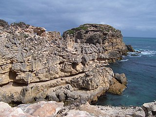
Carpenter Rocks is a town and locality located 35 kilometres (22 mi) south-west of Mount Gambier in the south-east of South Australia. The area faces the Southern Ocean and is renowned for its rugged coastline which provides exceptional fishing and diving locations.

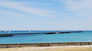
Cape Jaffa is a headland in the Australian state of South Australia located at the south end of Lacepede Bay on the state's south east coast about 20 kilometres south west of the town centre of Kingston SE. The cape is described as being "a low sandy point" with "its sea face is about One nautical mile (1.9 km) long" and having a "wooded range rises near the S[outh] part of the cape and reaches a height of 77 metres at Mount Benson, about 8.5 nautical miles S[outh] E[ast]". A settlement known as King's Camp in some sources and as Cape Jaffa in other sources is located about 0.5 nautical miles to the north west of the cape. This settlement includes a jetty fitted with a navigation aid and a marina. The southern coastline of the cape forms part of the Bernouilli Conservation Reserve.
Rivoli Bay, is a bay located on the south-east coast of the Australian state of South Australia about 311 kilometres south-southeast of the state capital of Adelaide and about 65 kilometres northwest by west of the regional centre of Mount Gambier. It was named in 1802 by the Baudin expedition of 1800-03 after André Masséna, the Duke of Rivoli and Marshal of France. It is one of four 'historic bays' located on the South Australian coast.

Lacepede Bay is a bay in the Australian state of South Australia located on the state's south-east coast about 140 kilometres northwest of Mount Gambier and about 240 kilometres southeast of Adelaide. It was named in 1802 by the Baudin expedition of 1800-03 after Bernard Germain de Lacépède, the French naturalist. It is one of four ‘historic bays’ located on the South Australian coast.
Bucks Lake Game Reserve, formerly the Bucks Lake National Park, is a protected area located in the Limestone Coast of South Australia about 40 kilometres south-west of Mount Gambier and immediately east of the township of Carpenter Rocks. The game reserve was originally created as the Bucks Lake National Park in 1968 under the National Parks Act 1966 and was re-proclaimed as a game reserve under the National Parks and Wildlife Act 1972 for the purpose of the conservation of wildlife and management of game. The game reserve is used for duck hunting with species being harvested including grey teal, chestnut teal, Pacific black duck, pink-eared duck and Australian shelduck. Hunting is conducted during a proclaimed open season with hunters requiring to have an ‘endorsed hunting permit’ and only to harvest maximum numbers of specific species.
Cape Northumberland is a headland in the southeast of the Australian state of South Australia. It is the southernmost point of South Australia. It is located about 3 kilometres (1.9 mi) from the town of Port MacDonnell, 28 kilometres south southwest from the municipal seat of Mount Gambier and about 393 kilometres (244 mi) southeast of the state's capital Adelaide.
West Cape is a headland located on the west coast of the Yorke Peninsula in South Australia in the gazetted locality of Inneston about 14 kilometres west of the town of Marion Bay. It is the most westerly point of Yorke Peninsula. Since 1970, the headland has been located within the Innes National Park while the waters adjoining its shoreline have been located within the Southern Spencer Gulf Marine Park since 2012. Since 1980, it has been the site of a navigation aid in the form of a lighthouse.

Cape Willoughby is a headland in the Australian state of South Australia located on the east end of the Dudley Peninsula on Kangaroo Island in the gazetted locality of Willoughby about 22 kilometres south east of the town of Penneshaw.
Cape St Albans is a headland in the Australian state of South Australia located on the north coast of the Dudley Peninsula on Kangaroo Island in the gazetted locality of Willoughby about 18 kilometres south-east of the town of Penneshaw.
Cape Jervis is a headland located at the most westerly part of the Fleurieu Peninsula on the east coast of Gulf St Vincent in South Australia about 0.7 kilometres west of the town of the same name, Cape Jervis. It is the eastern end of the opening to Gulf St Vincent.

Calca Peninsula is a peninsula in the Australian state of South Australia located on the west coast of Eyre Peninsula in the locality of Sceale Bay about 27 kilometres to about 46 kilometres south-east of the town of Streaky Bay.
Slade Point is a headland in the Australian state of South Australia located on the west coast of Eyre Peninsula in the locality of Sceale Bay about 29 kilometres (18 mi) south of the town of Streaky Bay. The point is the northern extremity of Searcy Bay and the southern extremity of a promontory that separates Searcy Bay in the south east from Sceale Bay in the north west. While it is within the coastline first charted by Matthew Flinders on 9 February 1802, it is not named by Flinders possibly due to the coastline being obscured by a thick haze. Slade Point was named in 1908 after “the late Mr. W. E. Slade” who served as the Assistant Engineer of Harbours in the South Australian Government. The cape has adjoined the boundary of the Cape Blanche Conservation Park since 2012 while the waters adjoining its shoreline have been within a habitat protection zone in the West Coast Bays Marine Park also since 2012.
Cape Douglas is a locality in the Australian state of South Australia located on the state’s south-east coast overlooking the body of water known in Australia as the Southern Ocean and by international authorities as the Great Australian Bight. It is about 386 kilometres south-east of the state capital of Adelaide and 24 kilometres south of the municipal seat of Mount Gambier.

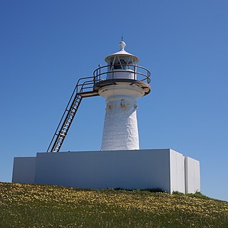
Cape Banks Lighthouse is a lighthouse in the Australian state of South Australia located in the state's south-east on an unnamed headland in the gazetted locality of Carpenter Rocks about 2.5 kilometres (1.6 mi) north-west of the locality's town centre.
Kellidie Bay is a locality in the Australian state of South Australia located on the Eyre Peninsula in the state’s west overlooking parts of the body of water known as Coffin Bay about 290 kilometres (180 mi) west of the state capital of Adelaide and about 42 kilometres (26 mi) south-west of the municipal seat of Cummins.
Christmas Rocks Conservation Park is a protected area located in the Australian state of South Australia in the locality of Willalooka about 224 kilometres (139 mi) south-east of the state capital of Adelaide and about 29 kilometres (18 mi) south of the town of Keith.

Sleaford Bay is a bay located in the Australian state of South Australia on the southern coast of Eyre Peninsula. It was named by the British navigator, Matthew Flinders in 1802.

