
Tantanoola is a town in regional South Australia. The name is derived from the aboriginal word tentunola, which means boxwood / brushwood hill or camp. Tantanoola was originally named 'Lucieton' by Governor Jervois after his daughter Lucy Caroline, on 10 July 1879. It was changed by Governor Robinson to 'Tantanoola' on 4 October 1888. At the 2006 census, Tantanoola had a population of 255.
Port MacDonnell, originally known as Ngaranga, is the southernmost town in South Australia. The small port is located in the Limestone Coast region, about 477 kilometres (296 mi) south-east of Adelaide and 28 kilometres (17 mi) south of Mount Gambier, in the District Council of Grant local government area. Once a busy shipping port, the town now relies heavily on its fishing and summer tourism industries, particularly the rock lobster industry, proclaiming itself "Australia's Southern Rock Lobster Capital".
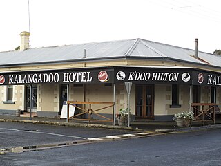
Kalangadoo, formerly Kalangadoo East, is a locality in the Australian state of South Australia located about 348 kilometres (216 mi) south-east of the state capital of Adelaide and about 31 kilometres (19 mi) north of the regional centre of Mount Gambier.
Donovans is a locality in the Australian state of South Australia located in the state's south-east on the Glenelg River adjoining the border with the state of Victoria. It is about 403 kilometres south-east of the state capital of Adelaide and 26 kilometres south-east of the centre of the city of Mount Gambier.
Wye is a locality in the Australian state of South Australia located on the state's south-east coast adjoining the border with the state of Victoria and overlooking Discovery Bay in the body of water known in Australia as the Southern Ocean and by international authorities as the Great Australian Bight. It is about 399 kilometres south-east of the state capital of Adelaide and 22 kilometres south-east of the city centre of Mount Gambier.
Pelican Point is a coastal town in South Australia that surrounds a headland on the continental coastline. It consists mostly of holiday shacks. The north side of the point faces Bungaloo Bay. The point was previously known as Pointe des Cordonniers. The current boundaries were created on 31 October 1996 including both the Bungaloo Bay and Pelican Point shack areas.
Allendale East is a town and locality in the Australian state of South Australia located in the state's south-east about 391 kilometres (243 mi) south-east of the state capital of Adelaide and about 20 kilometres (12 mi) south of the municipal seat of Mount Gambier.
Burrungule is a locality in South Australia.
Hynam is a town and locality in the Australian state of South Australia located in the state's south-east within the Limestone Coast region on the border with the state of Victoria about 302 kilometres south east of the state capital of Adelaide and about 11 kilometres east of the municipal seat of Naracoorte.

Kongorong is a locality in the Australian state of South Australia located southwest of Mount Gambier. It has an Australian rules football team and netball team. Kongorong Primary School had 61 students in 2010.
Mil-Lel is a northern suburb of Mount Gambier.
Nangwarry is a town and a locality in the Australian state of South Australia located about 352 kilometres (219 mi) south-east of the state capital of Adelaide and about 32 kilometres (20 mi) north-west of the regional centre of Mount Gambier.
Yahl is a Hamlet that is approximately 7 kilometres south east from Mount Gambier.
OB Flat is a south-eastern suburb of Mount Gambier in South Australia.
Wandilo is a north-western suburb of Mount Gambier in the Australian state of South Australia. It was named after the railway station on the Mount Gambier railway line, and is recorded to mean "a swamp where native companions resort".
Glenburnie is an eastern suburb of Mount Gambier.

Canunda is a locality in the Australian state of South Australia located on the state’s south-east coast overlooking the body of water known in Australia as the Southern Ocean and by international authorities as the Great Australian Bight. It is about 339 kilometres south-east of the state capital of Adelaide and 49 kilometres south of the centre of Mount Gambier.
Dismal Swamp is a locality in the Australian state of South Australia located about 361 kilometres (224 mi) south-east of the state capital of Adelaide and about 19 kilometres (12 mi) north-west of the municipal seat of Mount Gambier.
Suttontown is a north-western suburb of Mount Gambier, a city in the south-east of South Australia.
Mingbool is a locality in the Australian state of South Australia located about 372 kilometres (231 mi) south-east of the state capital of Adelaide adjoining the border with the state of Victoria and about 16 kilometres (9.9 mi) north-west of the municipal seat of Mount Gambier.
