James Grant was a Scottish born British Royal Navy officer and navigator in the early nineteenth century. He served in Australia in 1800-1801 and was the first to map parts of the south coast of Australia.

Mount Gambier is the second most populated city in South Australia with an estimated urban population of 29,639. The city is located on the slopes of Mount Gambier, a volcano in the south east of the state, about 450 kilometres (280 mi) south-east of the capital Adelaide and just 17 kilometres (11 mi) from the Victorian border. The traditional owners of the area are the Bungandidj people.
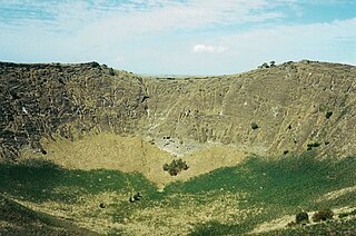
A maar is a broad, low-relief volcanic crater caused by a phreatomagmatic eruption. A maar characteristically fills with water to form a relatively shallow crater lake which may also be called a maar. The name comes from a Moselle Franconian dialect word used for the circular lakes of the Daun area of Germany.

The Blue Lake is a large, monomictic, crater lake located in a dormant volcanic maar associated with the Mount Gambier maar complex. The lake is situated near Mount Gambier in the Limestone Coast region of South Australia, and is one of four crater lakes on Mount Gambier maar. Of the four lakes, only two remain, as the other two have dried up over the past 30 to 40 years as the water table has dropped.
Lake Purrumbete is a volcanic lake located in the Western District of Victoria, Australia. Lake Purrumbete is approximately 15 km (9.3 mi) east of the town of Camperdown. The lake is in a shallow maar. The water is crystal clear most times of the year as the lake relies totally on its own catchment.

Fort Rock is a tuff ring located on an ice age lake bed in north Lake County, Oregon, United States. The ring is about 4,460 feet (1,360 m) in diameter and stands about 200 feet (60 m) high above the surrounding plain. Its name is derived from the tall, straight sides that resemble the palisades of a fort. The region of Fort Rock-Christmas Lake Valley Basin contains about 40 such tuff rings and maars and is located in the Brothers Fault Zone of central Oregon's Great Basin. William Sullivan, an early settler in the area, named Fort Rock in 1873 while searching for lost cattle.
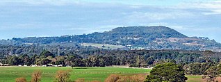
Mount Schank is a 100 m (330 ft) high dormant volcano in the southeast corner of South Australia, near Mount Gambier. It was sighted by James Grant on 3 December 1800 and named after Admiral John Schank, designer of Grant's ship, HMS Lady Nelson.
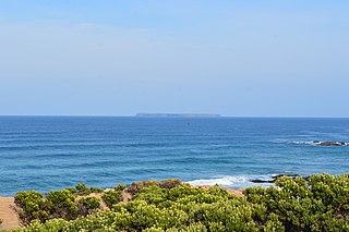
Lady Julia Percy Island, known as Deen Maar or Dhinmar in the Gunditjmara language, lies 8.1 kilometres (5.0 mi) off the coast, in the Barwon South West region of Victoria, Australia in Bass Strait. The island is an unincorporated area under the direct administration of the government of Victoria.
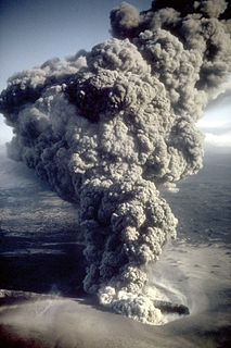
Phreatomagmatic eruptions are volcanic eruptions resulting from interaction between magma and water. They differ from exclusively magmatic eruptions and phreatic eruptions. Unlike phreatic eruptions, the products of phreatomagmatic eruptions contain juvenile (magmatic) clasts. It is common for a large explosive eruption to have magmatic and phreatomagmatic components.
The Newer Volcanics Province is a geological area which is a volcanic field, formed by the East Australia hotspot across south-eastern Australia. It covers an area of 15,000 square kilometres (5,800 sq mi), with over 400 small shield volcanoes and volcanic vents. The area contains the youngest volcanoes in Australia.

Blue Lake Crater is a maar, or a broad, low-relief volcanic crater, in the U.S. state of Oregon. Located in Jefferson County, it consists of three overlapping craters, which hold Blue Lake. The drainage basin for Blue Lake has very steep, forested slopes and is mostly part of the explosion crater left by the volcano's eruption. The volcano lies within the Metolius River basin, which supports a wide array of plant life, large and small mammals, and more than 80 bird species. In 2009, Governor of Oregon Ted Kulongoski signed a bill designating the Metolius River basin as an area of critical concern, preventing large-scale development on the land and protecting its wildlife.

Lake Bullen Merri and its smaller northern neighbour Lake Gnotuk are a pair of crater lakes near Camperdown in south western Victoria, Australia.
Mount Leura is a 313-metre scoria cone surrounding a dry crater 100 m deep and is the central and most obvious component of a larger volcanic complex southeast of the town of Camperdown located in western Victoria, Australia, 194 kilometres (121 mi) south west of the state capital, Melbourne. The inactive volcano is thought to have last erupted between 5,000 and 20,000 years ago. The name means "big nose" in local aboriginal dialect.

South Australia is an Australian state, situated in the southern central part of the country, and featuring some low-lying mountain ranges, the most significant being the Mount Lofty Ranges, which extend into the state's capital city, Adelaide, which comprises most of the state's population. Adelaide is situated on the eastern shores of Gulf St Vincent, on the Adelaide Plains, north of the Fleurieu Peninsula, between Gulf St Vincent and the low-lying Mount Lofty Ranges. The state of South Australia, which stretches along the coast of the continent and has boundaries with every other state in Australia, with the exception of the Australian Capital Territory and Tasmania. The Western Australia border has a history with South Australia, involving the South Australian Government Astronomer, Dodwell and the Western Australian Government Astronomer, Curlewis in the 1920s to mark the border on the ground.
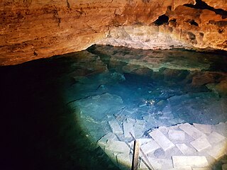
Little Blue Lake is a water-filled doline in the Australian state of South Australia located in the state's south-east in the locality of Mount Schank about 20 kilometres (12 mi) south of the municipal seat of Mount Gambier. It is notable locally as a swimming hole and nationally as a cave diving site. It is managed by the District Council of Grant and has been developed as a recreational and tourism venue.

The Valley Lake is a monomictic volcanic crater lake in the Australian state of South Australia situated in the south of Mount Gambier, near the Blue Lake. The Lake is surrounded by a park situated on Davidson Drive. The shore of the lake features a children's playground, sporting facilities, BBQs and toilets. There is also a Conservation Park, as well as Centenary Tower at the top of the surrounding crater.
Engelbrecht Cave is a cave system in the Australian state of South Australia consisting of a sinkhole with two major passages located under the Mount Gambier urban area. It is owned by the local government area of City of Mount Gambier and has been developed as a tourism venue. Its dry extent is notable as a show cave while its water-filled extent is notable as two separate cave diving sites.

Lake Meke is a volcanic crater lake composed of two nested lakes located in Konya Province, central Turkey. It is a registered natural monument of the country and a Ramsar site.
The geology of Cameroon is almost universally Precambrian metamorphic and igneous basement rock, formed in the Archean as part of the Congo Craton and the Central African Mobile Zone and covered in laterite, recent sediments and soils. Some parts of the country have sequences of sedimentary rocks from the Paleozoic, Mesozoic and Cenozoic as well as volcanic rock produced by the 1600 kilometer Cameroon Volcanic Line, which includes the still-active Mount Cameroon. The country is notable for gold, diamonds and some onshore and offshore oil and gas.

A volcanic crater lake is a lake in a crater that was formed from explosive activity or collapse during a volcanic eruption.

