This page is based on this
Wikipedia article Text is available under the
CC BY-SA 4.0 license; additional terms may apply.
Images, videos and audio are available under their respective licenses.

The Blue Lake is a large, monomictic, crater lake located in a dormant volcanic maar associated with the Mount Gambier maar complex. The lake is situated near Mount Gambier in the Limestone Coast region of South Australia, and is one of four crater lakes on Mount Gambier maar. Of the four lakes, only two remain, as the other two have dried up over the past 30 to 40 years as the water table has dropped.

Mount Gambier Gaol opened in 1866 and closed in 1995, when it was replaced by a new Mount Gambier Prison on a different site. The former gaol is listed on South Australian Heritage Register.

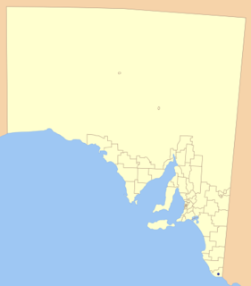
Mount Gambier is a single-member electoral district for the South Australian House of Assembly. It covers the far south-east corner of the state containing the City of Mount Gambier and District Council of Grant local government areas. It is centred on the city and extinct volcano of Mount Gambier.
Mount Schank is a 100 m (330 ft) high volcanic cone in the southeast corner of South Australia, near Mount Gambier. It was sighted by James Grant on 3 December 1800 and named after Admiral John Schank, designer of Grant's ship, HMS Lady Nelson.

The East Australia hotspot is a volcanic hotspot that forces magma up at weak spots in the Indo-Australian Plate to form volcanoes in Eastern Australia. It does not produce a single chain of volcanoes like the Hawaiian Islands. Unlike most hotspots, the East Australia hotspot has explosive eruptions, as well as the runny lava flows of the Hawaii hotspot, the Iceland hotspot and the Réunion hotspot. The hotspot is explosive because basaltic magma interacts with groundwater in aquifers below the surface producing violent phreatomagmatic eruptions.

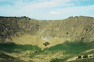
The Newer Volcanics Province is a complex of volcanic centres formed by the East Australia hotspot across south-eastern Australia. It has an area of 6,000 square miles with over 400 vents and contains the youngest volcanoes in Australia. The youngest eruptions in the volcanic field took place at Mount Schank and Mount Gambier about 5000 years ago, when explosive activity formed several maars and associated lava flows.

The District Council of Grant is a local government area located in the Limestone Coast region of South Australia, and is the southernmost council in the state.
Wandilo is a settlement in the Australian state of South Australia. It was named after the railway station on the Mount Gambier railway line, and is recorded to mean "a swamp where native companions resort".
Little Blue Lake is a water-filled doline in the Australian state of South Australia located in the state's south-east in the locality of Mount Schank about 20 kilometres (12 mi) south of the municipal seat of Mount Gambier. It is notable locally as a swimming hole and nationally as a cave diving site. It is managed by the District Council of Grant and has been developed as a recreational and tourism venue.
Mount Gambier railway station was the junction station for the Naracoorte–Millicent and Mount Gambier-Heywood lines in the South Australian city of Mount Gambier.
Glenburnie is a town in the Australian state of South Australia located in the state's southeast adjoining the border with Victoria about 385 kilometres (239 mi) south-east of the state capital of Adelaide and about 9.3 kilometres (5.8 mi) east of the municipal seat of Mount Gambier.
The Mount Gambier railway line was a railway line on the South Australian Railways network. Opened in stages from 1881, it was built to narrow gauge and joined Mount Gambier railway station, which was at that time the eastern terminus of a line to Beachport. It connected at Naracoorte to another isolated narrow gauge line joining Naracoorte to Kingston SE, and to the broad gauge Adelaide-Wolseley line at Wolseley, at around the same time that was extended to Serviceton to become the South Australian part of the Melbourne–Adelaide railway. There has been regular calls for its standardisation between Wolseley and Heywood since its closure over the past two decades.

Mount Schank is a locality in the Australian state of South Australia located about 385 kilometres south-east of the state capital of Adelaide and 14 kilometres south of the municipal seat of Mount Gambier in the south-east of the state.
The Valley Lake is a monomictic crater lake in the Australian state of South Australia situated in the south of Mount Gambier, near the Blue Lake. The Lake is surrounded by a park situated on Davidson Drive. The shore of the lake features a kids playground, sporting facilities, BBQs and toilets. There is also a Wildlife Park, as well as Centenary Tower at the top of the surrounding crater.
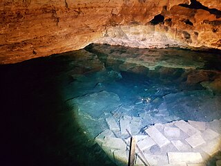
Engelbrecht Cave is a cave system in the Australian state of South Australia consisting of a sinkhole with two major passages located under the Mount Gambier urban area. It is owned by the local government area of City of Mount Gambier and has been developed as a tourism venue. Its dry extent is notable as a show cave while its water-filled extent is notable as two separate cave diving sites.

Mount Gambier-Heywood railway line is a 5 ft 3 in line located in Australia which operated from 27 November 1917 to 11 April 1995 between Mount Gambier in the state of South Australia and Heywood in the state of Victoria. It is one of two railway lines built by both state governments following an agreement in 1912 to connect to each other’s railway networks. There has been calls for standardisation over the past 2 decades from Heywood to Wolseley since the Melbourne to Adelaide line was converted in 1995.