
Padthaway is a small town in the Australian state of South Australia located in the state's south-east within the Limestone Coast region about 253 kilometres south east of the state capital of Adelaide and about 41 kilometres south-east of the municipal seat of Bordertown. The name is derived from the Potawurutj, the Aboriginal name word for cover or bury. Padthaway is in the Tatiara District Council, the state electorate of MacKillop and the federal Division of Barker.

The Limestone Coast is a name used since the early twenty-first century for a South Australian government region located in the south east of South Australia which immediately adjoins the continental coastline and the Victorian border. The name is also used for a tourist region and a wine zone both located in the same part of South Australia.

Keith is a town and a locality in the Australian state of South Australia located in the state's south-east about 225 kilometres (140 mi) from the state capital of Adelaide at the junction of the Dukes Highway and the Riddoch Highway. It is sometimes referred to as the 'lucerne capital of Australia' due to the high number of lucerne growers in the region.

Bordertown, formerly Border Town, is a town and locality in the Australian state of South Australia located in the state's east near the state border with Victoria about 250 kilometres (160 mi) east of the state capital of Adelaide. It is where the Dukes Highway and the railway line cross the Tatiara Creek between Adelaide and Melbourne, the capital of Victoria.
Wolseley is a small South Australian town near the Victorian border. It is five kilometres south of the Dukes Highway and 13 kilometres east of Bordertown. It was first proclaimed a town in 1884.
The Kowree-Naracoorte-Tatiara Football League is an Australian rules football competition based in the Limestone Coast region of South Australia, Australia. It is an affiliated member of the South Australian National Football League. One unusual aspect of the league is that it includes clubs from both South Australia and Victoria. The 2018–21 league medalist was Darcy “Sauce” Boyanton.

Mundulla is a town and a locality in south eastern South Australia. The town is located in the local government area of Tatiara District Council about 278 kilometres (173 mi) south east of the state capital of Adelaide.
Albert was an electoral district of the House of Assembly in South Australia, spanning its time as both a colony and a state. It was created in 1875, taking much territory from adjacent Victoria, merged with Victoria in 1902 as Victoria and Albert, separated again in 1915, and abolished in 1970.

Limestone Coast zone is a wine zone located in the south east of South Australia. It extends south of a line of latitude approximately in line with Cape Willoughby at the east end of Kangaroo Island and it is bounded by the continental coastline and the border with Victoria. It consists of the following wine regions all of which have received appellation as an Australian Geographical Indication (AGI): Coonawarra, Mount Benson, Mount Gambier, Robe, Padthaway, Wrattonbully and a small number of vineyards located outside the above regions. The zone received AGI in 1996.

The District Council of Wirrega was a short-lived local government area in South Australia in existence from 1884 to 1888.
TheBorder Chronicle is a weekly newspaper published in Bordertown, South Australia from June 1908 to the present day. Its head office is in Smith Street, Naracoorte. It was later sold to Rural Press, previously owned by Fairfax Media, but now an Australian media company trading as Australian Community Media.

The County of Buckingham is one of the 49 cadastral counties of South Australia. It was proclaimed by Governor James Fergusson in 1869 and named for the third Duke of Buckingham and Chandos, Richard Temple-Nugent-Brydges-Chandos-Grenville who was appointed Secretary of State for the Colonies in 1867. It is located adjacent to the Victorian border in the state's upper south east. This includes most of the contemporary local government area of Tatiara District Council and a small east portion of Coorong District Council.
The County of MacDonnell is one of the 49 cadastral counties of South Australia. It was proclaimed in 1857 and named for the South Australian Governor at the time of proclamation, Richard Graves MacDonnell. It is located in the upper south-east of the state from the Limestone Coast at Kingston to the Victorian border. This includes the following contemporary local government areas of the state:
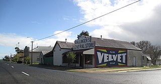
Willalooka is a small service town and locality in the Limestone Coast region of South Australia. it is located on the Riddoch Highway between Keith and Padthaway. Christmas Rocks Conservation Park is north of the town adjacent to the highway.
Bangham is a locality in the Australian state of South Australia located in the state's south-east within the Limestone Coast region about 279 kilometres south east of the state capital of Adelaide, about 31.5 kilometres south-east of the municipal seat of Bordertown and adjoining the border with the State of Victoria.
Custon is a locality in the Australian state of South Australia located in the state's south-east within the Limestone Coast region about 267 kilometres south east of the state capital of Adelaide, about 19.5 kilometres south-east of the municipal seat of Bordertown and adjoining the border with the State of Victoria.
Sherwood is a locality in the Australian state of South Australia located about 222 kilometres (138 mi) south-east of the state capital of Adelaide and about 30 kilometres (19 mi) north-west of the municipal seat of Bordertown.
Makin is a locality in the Australian state of South Australia located on the state’s south-east about 208 kilometres (129 mi) south-east of the state capital of Adelaide and about 50 kilometres (31 mi) north-west of the municipal seat of Bordertown.
Western Flat is a locality in the Australian state of South Australia located in the state's south-east within the Limestone Coast region about 264 kilometres (164 mi) south east of the state capital of Adelaide and about 22 kilometres (14 mi) south of the municipal seat of Bordertown.
Bordertown South is a locality in the Australian state of South Australia located in the state's south-east within the Limestone Coast region about 255 kilometres (158 mi) east of the state capital of Adelaide and about 14 kilometres (8.7 mi) south of the municipal seat of Bordertown.

