
Padthaway is a small town in the Australian state of South Australia located in the state's south-east within the Limestone Coast region about 253 kilometres south east of the state capital of Adelaide and about 41 kilometres south-east of the municipal seat of Bordertown. The name is derived from the Potawurutj, the Aboriginal name for Good Water. Padthaway is in the Tatiara District Council, the state electorate of MacKillop and the federal Division of Barker.

Keith is a town and a locality in the Australian state of South Australia located in the state's south-east about 225 kilometres (140 mi) from the state capital of Adelaide at the junction of the Dukes Highway and the Riddoch Highway. It is sometimes referred to as the 'lucerne capital of Australia' due to the high number of lucerne growers in the region.

Bordertown, formerly Border Town, is a town and locality in the Australian state of South Australia located in the state's east near the state border with Victoria about 250 kilometres (160 mi) east of the state capital of Adelaide. It is where the Dukes Highway and the railway line cross the Tatiara Creek between Adelaide and Melbourne, the capital of Victoria.
Taplan is a town in the Murray Mallee region of South Australia near the border with Victoria. Taplan is an aboriginal word meaning grass tree. The town was laid out by Henry George in 1914. The railway from Adelaide to Paringa was laid past the site of the future township in 1913, 183.25 miles (294.91 km) by rail from Adelaide. The Taplan Post Office was open from 1 July 1914 to 14 May 1982.
Wolseley is a small South Australian town near the Victorian border. It is five kilometres south of the Dukes Highway and 13 kilometres east of Bordertown. It was first proclaimed a town in 1884.
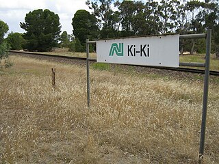
Ki Ki is a small town in South Australia. It is on the Dukes Highway (A8) adjacent to the Adelaide-Melbourne railway, the main links between Adelaide and Melbourne. The town is the primary settlement for the Hundred of Livingston.

Tatiara District Council is a local government area located in south eastern South Australia. The name Tatiara is said to mean "the good country", a phrase which dates back to the area's first inhabitants. It is also one of the largest local government areas in South Australia at 6,476 km2 (2,500 sq mi). The district's economy is based primarily on agriculture, with cereal crops such as wheat, barley and oats and with livestock such as sheep, cattle and pigs prominent.

Buccleuch is a place in South Australia situated along the Pinnaroo railway line and Mallee Highway (B12), approximately 140 km east of Adelaide. It is part of the Coorong District Council. There is an active Lutheran Church in Buccleuch.
Peebinga is a town and locality in the Australian state of South Australia. Peebinga was the terminus of the Peebinga railway line which was built in 1914 as part of a major state government project to open up the Murray Mallee for grazing and cropping.
Elwomple is a locality in The Coorong District Council in the South Australian Murray Mallee, southeast of Tailem Bend. The northwest corner is the junction of the Mallee Highway which forms the northern boundary of Elwomple, and the Dukes Highway which forms the southwestern boundary. The Bend Motorsport Park was developed in Elwomple adjacent to this junction. In September 2017, before the facility opened, the boundary between Tailem Bend and Elwomple was adjusted so that The Bend Motorsport Park was officially in Tailem Bend, not Elwomple.
Sherlock is a town and locality in the Australian state of South Australia. It is on the Pinnaroo railway line and Mallee Highway.
Ucolta is a locality in the Mid North region of South Australia. It is named for a railway station on the Broken Hill-Port Pirie railway line. Trains no longer stop at Ucolta. It is also where the Barrier Highway first meets the railway line, and the Wilmington–Ucolta Road which connects across the northern side of the Mid North, providing the shortest road route from Western Australia and Eyre Peninsula via Port Augusta to Broken Hill and New South Wales.

Ulooloo is a locality in the Mid North of South Australia. It is midway between Burra and Peterborough on the Barrier Highway from Adelaide to Broken Hill, New South Wales.
Fords is a locality in the Mid North region of South Australia, southwest of Kapunda, South Australia. It is crossed by the Thiele Highway, and the former Morgan railway line. The northern boundary of Fords is the Light River. Fords is named after an early landowner, John Ford.
Willalooka is a small service town and locality in the Limestone Coast region of South Australia. it is located on the Riddoch Highway between Keith and Padthaway. Christmas Rocks Conservation Park is north of the town adjacent to the highway.
Custon is a locality in the Australian state of South Australia located in the state's south-east within the Limestone Coast region about 267 kilometres south east of the state capital of Adelaide, about 19.5 kilometres south-east of the municipal seat of Bordertown and adjoining the border with the State of Victoria.
Sherwood is a locality in the Australian state of South Australia located about 222 kilometres (138 mi) south-east of the state capital of Adelaide and about 30 kilometres (19 mi) north-west of the municipal seat of Bordertown.
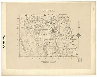
The Hundred of Townsend is a cadastral unit of hundred located in the Limestone Coast region in the south-east of South Australia.
Maude is a locality on the Goyder Highway in the Mid North region of South Australia.

Milendella is a locality on the plains to the east of the Mount Lofty Ranges in South Australia. It was once a stop on the Sedan railway line. The name Milendella was approved by the state Nomenclature Committee in 1917 in advance of the railway opening in 1919. The name was the native name of Emu Creek which runs through the locality.
