Sherwood, South Australia

Last updated

Sherwood
South Australia
Australia South Australia location map.svg
Red pog.svg
Sherwood
Coordinates 36°05′18″S140°36′37″E / 36.088390°S 140.610370°E / -36.088390; 140.610370 Coordinates: 36°05′18″S140°36′37″E / 36.088390°S 140.610370°E / -36.088390; 140.610370 [1]
Population 97 (2016 census) [2]
Established 16 March 2000 [3]
Postcode(s) 5267 [4]
Time zone ACST (UTC+9:30)
 • Summer (DST) ACST (UTC+10:30)
Location
LGA(s) Tatiara District Council [1]
Region Limestone Coast [5]
County MacDonnell [1]
State electorate(s) MacKillop [6]
Federal Division(s) Barker [7]
Mean max tempMean min tempAnnual rainfall
22.3 °C
72 °F
9.1 °C
48 °F
460.9 mm
18.1 in
Suburbs around Sherwood:
Coombe Coombe
Makin
McCallum
Shaugh
Keith Sherwood Senior
Lowan Vale
Keith Brimbago
Wirrega
Lowan Vale
Lowan Vale
Footnotes Coordinates [1]
Locations [4] [1]
Climate [8]
Adjoining localities [1]

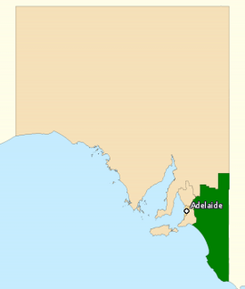
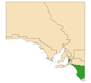
Sherwood is a locality in the Australian state of South Australia located about 222 kilometres (138 mi) south-east of the state capital of Adelaide and about 30 kilometres (19 mi) north-west of the municipal seat of Bordertown. [1] [4]

South Australia State of Australia

South Australia is a state in the southern central part of Australia. It covers some of the most arid parts of the country. With a total land area of 983,482 square kilometres (379,725 sq mi), it is the fourth-largest of Australia's states and territories by area, and fifth largest by population. It has a total of 1.7 million people, and its population is the second most highly centralised in Australia, after Western Australia, with more than 77 percent of South Australians living in the capital, Adelaide, or its environs. Other population centres in the state are relatively small; Mount Gambier, the second largest centre, has a population of less than 30,000.

Adelaide city centre Suburb of Adelaide, South Australia

Adelaide city centre is the innermost locality of Greater Adelaide, the capital city of South Australia. It is known by locals simply as "The City" or "Town" to distinguish it from Greater Adelaide and from the City of Adelaide. The locality is split into two key geographical distinctions: the city "square mile", bordered by North, East, South and West Terraces; and the section of the parklands south of the River Torrens which separates the built up part of the city from the surrounding suburbs and North Adelaide.

Bordertown, South Australia Town in South Australia

Bordertown is a South Australian town in the upper Limestone Coast region near the Victorian border. It is where the Dukes Highway and the railway line, the two main routes between Adelaide and Melbourne, cross Tatiara Creek.

Boundaries for the locality were created on 16 March 2000 for the “long established name.” [1] [3]

Sherwood is served by Emu Flat Road which passes through the locality from the Ngarkat Highway in the east where the highway forms the locality’s eastern boundary to Keith in the west where the road terminates in the Keith town centre. [1]

Ngarkat Highway

The Ngarkat Highway is a road in the southeastern part of South Australia, connecting Pinnaroo and Bordertown. It is designated as part of route B57 which continues north from Pinnaroo as the Browns Well Highway to Loxton. The route duplexes with B12 on the Mallee Highway for 6 km west of Pinnaroo. It ends at Cannawigara on the Dukes Highway 12 km west of Bordertown.

Keith, South Australia Town in South Australia

Keith is a town and a locality in the Australian state of South Australia located in the state's south-east about 225 kilometres (140 mi) from the state capital of Adelaide at the junction of the Dukes Highway and the Riddoch Highway. It is sometimes referred to as the 'lucerne capital of Australia' due to the high number of lucerne growers in the region.

The principal land use in the locality is primary production. A parcel of land at its eastern boundary has protected area status as the Hardings Springs Conservation Reserve. [9] [1]

Protected area location which receives protection because of its recognised natural, ecological or cultural landscape values

Protected areas or conservation areas are locations which receive protection because of their recognized natural, ecological or cultural values. There are several kinds of protected areas, which vary by level of protection depending on the enabling laws of each country or the regulations of the international organizations involved.

The 2016 Australian census which was conducted in August 2016 reports that Sherwood had a population of 97 people. [2]

The 2016 Australian census was the seventeenth national population census held in Australia. The census was officially conducted with effect on Tuesday, 9 August 2016. The total population of the Commonwealth of Australia was counted as 23,401,892 – an increase of 8.8 per cent or 1,894,175 people since the 2011 census. Norfolk Island joined the census for the first time in 2016, adding 1,748 to the population.

Sherwood is located within the federal division of Barker, the state electoral district of MacKillop and the local government area of the Tatiara District Council. [7] [6] [1]

Division of Barker Australian federal electoral division

The Division of Barker is an Australian Electoral Division in the south-east of South Australia. The division was established on 2 October 1903, when South Australia's original single multi-member division was split into seven single-member divisions. It is named for Collet Barker, an early explorer of the region at the mouth of the Murray River. The 63,886 km² seat currently stretches from Morgan in the north to Port MacDonnell in the south, taking in the Murray Mallee, the Riverland, the Murraylands and most of the Barossa Valley, and includes the towns of Barmera, Berri, Bordertown, Coonawarra, Keith, Kingston SE, Loxton, Lucindale, Mannum, Millicent, Mount Gambier, Murray Bridge, Naracoorte, Penola, Renmark, Robe, Tailem Bend, Waikerie, and parts of Nuriootpa and Tanunda.

Electoral district of MacKillop state electoral district of South Australia

MacKillop is a single-member electoral district for the South Australian House of Assembly. It was named in 1991 after Sister Mary MacKillop who served the local area, and later became the first Australian to be canonised as a Roman Catholic saint. MacKillop is a 25,313 km² rural electorate in the south-east of the state, stretching south and west from the mouth of the Murray River to the Victorian State border, but excluding the far-southern point of the state,. It contains the Kingston District Council, Naracoorte Lucindale Council, District Council of Robe, Tatiara District Council, Wattle Range Council, as well as parts of The Coorong District Council. The main population centres are Bordertown, Keith, Kingston SE, Meningie, Millicent, Naracoorte, Penola and Robe.

Tatiara District Council Local government area in South Australia

Tatiara District Council is a local government area located in south eastern South Australia. The name Tatiara is said to mean "the good country", a phrase which dates back to the area's first inhabitants. It is also one of the largest local government areas in South Australia at 6,476 km2 (2,500 sq mi). The district's economy is based primarily on agriculture, with cereal crops such as wheat, barley and oats and with livestock such as sheep, cattle and pigs prominent.

Related Research Articles

Mundulla Town in South Australia

Mundulla is a town in south eastern South Australia. The town is located in the local government area of Tatiara District Council about 278 kilometres (173 mi) south east of the state capital of Adelaide.

Avenue Range, South Australia Town in South Australia

Avenue Range is a locality in the Australian state of South Australia located in the state's south-east within the Limestone Coast region about 265 kilometres south east of the Adelaide city centre.

Mount Benson, South Australia Town in South Australia

Mount Benson is a locality in the Australian state of South Australia located on the state’s south-east coast overlooking Guichen Bay which is part of the body of water known in Australia as the Southern Ocean and by international authorities as the Great Australian Bight. It is about 269 kilometres south-east of the Adelaide city centre and 112 kilometres north-west of the centre of Mount Gambier.

Ngarkat, South Australia Suburb of Coorong District Council, Tatiara District Council, Southern Mallee District Council, South Australia

Ngarkat is a locality in the Australian state of South Australia located in the south-east of the state at the border with the state of Victoria in both the Murray Mallee and the Limestone Coast regions about 227 kilometres south east of the state capital of Adelaide.

Nora Creina, South Australia Suburb of District Council of Robe, Wattle Range Council, South Australia

Nora Creina is a locality in the Australian state of South Australia located on the state’s south-east coast overlooking the body of water known in Australia as the Southern Ocean and by international authorities as the Great Australian Bight. It is about 99 kilometres to the north-west of the city of Mount Gambier and about 290 kilometres south-east of the state capital of Adelaide.

West Range, South Australia Suburb of Kingston District Council, South Australia

West Range is a locality in the Australian state of South Australia located on the state’s south-east coast overlooking Lacepede Bay which is part of the body of water known in Australia as the Southern Ocean and by international authorities as the Great Australian Bight. It is about 232 kilometres south-east of the Adelaide city centre and 145 kilometres south of the centre of Mount Gambier.

Marcollat, South Australia Suburb of Kingston District Council , South Australia

Marcollat is a locality in the Australian state of South Australia located in the state’s Limestone Coast about 236 kilometres (147 mi) south-east of the state capital of Adelaide and about 45 kilometres (28 mi) north of the municipal seat of Kingston SE.

Keppoch, South Australia Suburb of Naracoorte Lucindale Council, South Australia

Keppoch is a locality in the Australian state of South Australia located in the state's south-east within the Limestone Coast region about 269 kilometres south east of the state capital of Adelaide and about 29 kilometres north-east of the municipal seat of Naracoorte.

Cadgee, South Australia Suburb of Naracoorte Lucindale Council, South Australia

Cadgee is a locality in the Australian state of South Australia located in the state's south-east within the Limestone Coast region about 280 kilometres south east of the state capital of Adelaide and about 18 kilometres north of the municipal seat of Naracoorte.

Willalooka, South Australia Town in South Australia

Willalooka is a small service town and locality in the Limestone Coast region of South Australia. it is located on the Riddoch Highway between Keith and Padthaway. Christmas Rocks Conservation Park is north of the town adjacent to the highway.

Bangham, South Australia Town in South Australia

Bangham is a locality in the Australian state of South Australia located in the state's south-east within the Limestone Coast region about 279 kilometres south east of the state capital of Adelaide, about 31.5 kilometres south-east of the municipal seat of Bordertown and adjoining the border with the State of Victoria.

Custon, South Australia Town in South Australia

Custon is a locality in the Australian state of South Australia located in the state's south-east within the Limestone Coast region about 267 kilometres south east of the state capital of Adelaide, about 19.5 kilometres south-east of the municipal seat of Bordertown and adjoining the border with the State of Victoria.

Joanna, South Australia Town in South Australia

Joanna is a locality in the Australian state of South Australia located in the state's south-east within the state’s Limestone Coast region about 325 kilometres south east of the state capital of Adelaide, about 19.5 kilometres south-east of the municipal seat of Naracoorte.

Petherick, South Australia Suburb of Tatiara District Council , South Australia

Petherick is a locality in the Australian state of South Australia located in the state’s south-east about 211 kilometres (131 mi) south-east of the state capital of Adelaide and about 55 kilometres (34 mi) west of the municipal seat in Bordertown.

Makin, South Australia Suburb of Tatiara District Council, South Australia

Makin is a locality in the Australian state of South Australia located on the state’s south-east about 208 kilometres (129 mi) south-east of the state capital of Adelaide and about 50 kilometres (31 mi) north-west of the municipal seat of Bordertown.

Deepwater, South Australia Suburb of Coorong District Council , South Australia

Deepwater is a locality in the Australian state of South Australia located in the state’s south-east about 190 kilometres (120 mi) south-east of the state capital of Adelaide and about 104 kilometres (65 mi) south-east of the municipal seat in Tailem Bend.

Laffer, South Australia Suburb of Tatiara District Council , South Australia

Laffer is a locality in the Australian state of South Australia located in the state’s south-east about 199 kilometres (124 mi) south-east of the state capital of Adelaide and about 57 kilometres (35 mi) west of the municipal seat in Bordertown.

Western Flat, South Australia Suburb of Tatiara District Council , South Australia

Western Flat is a locality in the Australian state of South Australia located in the state's south-east within the Limestone Coast region about 264 kilometres (164 mi) south east of the state capital of Adelaide and about 22 kilometres (14 mi) south of the municipal seat of Bordertown.

Colebatch, South Australia Suburb of Coorong District Council , South Australia

Colebatch is a locality in the Australian state of South Australia located in the state’s south-east about 162 kilometres (101 mi) south-east of the state capital of Adelaide and about 81 kilometres (50 mi) south-east of the municipal seat in Tailem Bend.

References

  1. 1 2 3 4 5 6 7 8 9 10 11 "Search result for "Sherwood (Locality Bounded)" (Record no SA0044778 with the following layers selected - "Suburbs and Localities", "County", "Hundred", "Place names (gazetteer)", "Road Labels" and "Development Plan Layers"". Property Location Browser. Government of South Australia. Retrieved 16 March 2017.
  2. 1 2 Australian Bureau of Statistics (27 June 2017). "Sherwood". 2016 Census QuickStats. Retrieved 24 April 2018. Blue pencil.svg
  3. 1 2 Lawson, Robert (16 March 2000). "GEOGRAPHICAL NAMES ACT 1991 Notice to Assign Names and Boundaries to Places (in the District Council of Tatiara)" (PDF). The South Australian Government Gazette. South Australian Government. p. 1434. Retrieved 24 April 2018.
  4. 1 2 3 "Postcode for Sherwood, South Australia" . Retrieved 18 March 2017.
  5. "Limestone Coast SA Government region" (PDF). The Government of South Australia. Retrieved 10 October 2014.
  6. 1 2 "District of MacKillop Background Profile". Electoral Commission SA. Retrieved 29 March 2016.
  7. 1 2 "Federal electoral division of Barker" (PDF). Australian Electoral Commission. Retrieved 28 March 2016.
  8. "Summary (climate) Summary statistics KEITH (nearest weather station)". Commonwealth of Australia, Bureau of Meteorology . Retrieved 18 March 2017.
  9. "Development Plan, Tatiara Council, Consolidated - 24 October 2013" (PDF). Government of South Australia. pp. 120–121, 134–135 and 205, 206. Retrieved 25 February 2017.