Kingston SE

Last updated

Kingston SE
South Australia
Kingston SE lobster.JPG
Lobster sculpture located at the entrance to the town
Australia South Australia location map.svg
Red pog.svg
Kingston SE
Coordinates 36°49′S139°51′E / 36.817°S 139.850°E / -36.817; 139.850 [1]
Population1,637 (UCL 2021) [2]
Established1861 (town)
3 December 1998 (locality) [1] [3]
Postcode(s) 5275 [4]
Time zone ACST (UTC+9:30)
 • Summer (DST) ACDT (UTC+10:30)
Location
LGA(s) Kingston District Council [1]
State electorate(s) MacKillop [5]
Federal division(s) Barker [6]
Mean max temp [7] Mean min temp [7] Annual rainfall [7]
19.3 °C
67 °F
10.4 °C
51 °F
494.1 mm
19.5 in
Localities around Kingston SE:
Lacepede Bay West Range Blackford
Lacepede Bay
Rosetown
Lacepede Bay
Kingston SE Blackford
Reedy Creek
Lacepede Bay Wyomi
Sandy Grove
Wangolina
Reedy Creek
Reedy Creek
FootnotesLocations [4]
Adjoining Localities [1]

Kingston SE (Kingston South East to distinguish it from Kingston on Murray), formerly Kingston, is a town in the Australian state of South Australia located in the state's south-east coastline on the shores of Lacepede Bay. It is located about 240 kilometres (150 miles) southeast of the state capital of Adelaide and 138 kilometres (86 miles) north-west of the centre of the city of Mount Gambier.

Contents

At the 2021 census, Kingston SE had a population of 1,637.

History

Aboriginal Australian people lived in the area for tens of thousands of years before the colonisation of South Australia. The place, known to the Tanganekald and Meintangk peoples as Tangalun, was at the border of the traditional lands of these two peoples. [8]

Kingston, South Australia was established in the 1800s by Archibald Cooke, his brother James Cooke, and James' wife Mary Macpherson Cooke, [9] and named Kingston in 1851. [8]

Much later a Sir George Strickland Kingston, a South Australian politician, surveyor and architect was chosen, for the coincidence of his name, to open the Kingston Post Office on 9 February 1869. [9] The extension on its name is to distinguish Kingston in the South East (of South Australia) from another "Kingston" in the state which is now officially named "Kingston on Murray". The extension was added in July 1940. [10]

The present-day town of Kingston SE includes the original Kingston, as well as the towns of Port Caroline and Maria Creek. [11] The latter was so named after the Maria, which wrecked near Kingston in 1840. The 26 survivors were massacred by local Aboriginal people, after which a punitive expedition under Major O'Halloran hanged two Aboriginal people, and an unknown number of others were also killed, according to Aboriginal oral history. [8]

The town was connected to Naracoorte by a 1,070 mm railway known as the Kingston-Naracoorte railway in 1876, providing a port for the grain and wool grown away from the coast. The rails were converted to broad gauge 1,600 mm with a new station built on the edge of town in 1959. The railway closed on 28 November 1987 then was dismantled on 15 September 1991. [12]

Media

The region was formerly serviced by two newspapers: the Kingston Weekly, the newspaper of The Kingston Traders' Association, was issued between 22 March 1946 and 30 March 1951. Later, the South-East Kingston Leader was started in Kingston, and was published from 1962 until 21 November 2001 when it was renamed Coastal Leader . It is now[ when? ] owned by Australian Community Media.[ citation needed ]

Today

At the 2021 census, Kingston SE had a population of 1,637. [13]

The main industries are fishing, wine-making, sheep and cattle farming and recreation, the district having a large influx of tourists during holiday periods throughout the year.

The northern entrance to the town is dominated by the Big Lobster, named "Larry" by people in Kingston. [14]

The town has an Australian rules football team competing in the Kowree-Naracoorte-Tatiara Football League. [15]

Kingston SE is home to the Cape Jaffa Lighthouse, which was moved to its current location from its former location on Margaret Brock Reef, and now operates as a museum. The museum also houses a lifeboat from MS Oliva which washed ashore after two years adrift.

Climate

Kingston SE has a warm-summer mediterranean climate (Köppen: Csb), with warm, dry summers and mild, drizzly winters. Average maxima vary from 24.8 °C (76.6 °F) in January to 14.1 °C (57.4 °F) in July and average minima fluctuate between 13.8 °C (56.8 °F) in January to 7.7 °C (45.9 °F) in July. Mean average annual precipitation is somewhat low: 494.1 mm (19.45 in), spread between 156.1 precipitation days. Extreme temperatures have ranged from 41.8 °C (107.2 °F) on 24 January 2021 to −0.7 °C (30.7 °F) on 15 June 2011. [16] Climate data was taken from the nearest weather station at Cape Jaffa.

Climate data for Kingston SE (36º58'12"S, 139º43'12"E, 17 m AMSL) (1991-2020 normals and extremes)
MonthJanFebMarAprMayJunJulAugSepOctNovDecYear
Record high °C (°F)41.8
(107.2)
40.8
(105.4)
38.4
(101.1)
33.1
(91.6)
27.2
(81.0)
22.4
(72.3)
19.5
(67.1)
23.3
(73.9)
27.6
(81.7)
34.0
(93.2)
38.4
(101.1)
40.3
(104.5)
41.8
(107.2)
Mean daily maximum °C (°F)24.8
(76.6)
24.4
(75.9)
22.7
(72.9)
20.0
(68.0)
16.9
(62.4)
14.8
(58.6)
14.1
(57.4)
14.6
(58.3)
16.2
(61.2)
18.7
(65.7)
21.3
(70.3)
22.9
(73.2)
19.3
(66.7)
Mean daily minimum °C (°F)13.8
(56.8)
13.6
(56.5)
12.6
(54.7)
10.8
(51.4)
9.4
(48.9)
8.0
(46.4)
7.7
(45.9)
7.9
(46.2)
8.6
(47.5)
9.3
(48.7)
10.7
(51.3)
12.3
(54.1)
10.4
(50.7)
Record low °C (°F)6.5
(43.7)
6.3
(43.3)
5.2
(41.4)
1.3
(34.3)
0.0
(32.0)
−0.7
(30.7)
0.1
(32.2)
0.2
(32.4)
1.0
(33.8)
2.6
(36.7)
3.4
(38.1)
4.7
(40.5)
−0.7
(30.7)
Average precipitation mm (inches)17.8
(0.70)
16.8
(0.66)
20.2
(0.80)
31.8
(1.25)
54.3
(2.14)
69.8
(2.75)
79.9
(3.15)
70.1
(2.76)
48.8
(1.92)
32.4
(1.28)
26.7
(1.05)
22.6
(0.89)
494.1
(19.45)
Average precipitation days (≥ 0.2 mm)5.54.68.512.817.519.020.621.116.712.88.98.1156.1
Average afternoon relative humidity (%)55575862717677747263585565
Average dew point °C (°F)11.7
(53.1)
12.2
(54.0)
11.3
(52.3)
10.3
(50.5)
10.2
(50.4)
9.2
(48.6)
9.0
(48.2)
8.6
(47.5)
9.4
(48.9)
9.1
(48.4)
10.1
(50.2)
10.5
(50.9)
10.1
(50.2)
Source: Bureau of Meteorology (1991-2024 normals and extremes) [7]

See also

Related Research Articles

<span class="mw-page-title-main">Padthaway, South Australia</span> Town in South Australia

Padthaway is a small town in the Australian state of South Australia located in the state's south-east within the Limestone Coast region about 253 kilometres south east of the state capital of Adelaide and about 41 kilometres south-east of the municipal seat of Bordertown. The name is derived from the Potawurutj, the Aboriginal name word for cover or bury. Padthaway is in the Tatiara District Council, the state electorate of MacKillop and the federal Division of Barker.

<span class="mw-page-title-main">Naracoorte, South Australia</span> Town in South Australia

Naracoorte is a town in the Limestone Coast region of South Australia, approximately 336 kilometres south-east of Adelaide and 100 kilometres north of Mount Gambier on the Riddoch Highway (A66).

<span class="mw-page-title-main">Limestone Coast</span> Region in South Australia

The Limestone Coast is a name used since the early twenty-first century for a South Australian government region located in the south east of South Australia which immediately adjoins the continental coastline and the Victorian border. The name is also used for a tourist region and a wine zone both located in the same part of South Australia.

<span class="mw-page-title-main">Keith, South Australia</span> Town in South Australia

Keith is a town and a locality in the Australian state of South Australia located in the state's south-east about 225 kilometres (140 mi) from the state capital of Adelaide at the junction of the Dukes Highway and the Riddoch Highway. It is sometimes referred to as the 'lucerne capital of Australia' due to the high number of lucerne growers in the region.

<span class="mw-page-title-main">Edenhope, Victoria</span> Town in Victoria, Australia

Edenhope is a town in Victoria, Australia. It is located on the Wimmera Highway, 30 kilometres from the South Australian border, in the Shire of West Wimmera local government area. At the 2016 census Edenhope had a population of 946.

<span class="mw-page-title-main">Bordertown, South Australia</span> Town in South Australia

Bordertown, formerly Border Town, is a town and locality in the Australian state of South Australia located in the state's east near the state border with Victoria about 250 kilometres (160 mi) east of the state capital of Adelaide. It is where the Dukes Highway and the railway line cross the Tatiara Creek between Adelaide and Melbourne, the capital of Victoria.

<span class="mw-page-title-main">Wolseley, South Australia</span> Town in South Australia

Wolseley is a small South Australian town near the Victorian border. It is five kilometres south of the Dukes Highway and 13 kilometres east of Bordertown. It was first proclaimed a town in 1884.

The Kowree-Naracoorte-Tatiara Football League is an Australian rules football competition based in the Limestone Coast region of South Australia, Australia. It is an affiliated member of the South Australian National Football League. One unusual aspect of the league is that it includes clubs from both South Australia and Victoria. The 2018–21 league medalist was Darcy “Sauce” Boyanton.

<span class="mw-page-title-main">Mundulla</span> Town in South Australia

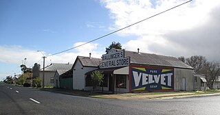
Mundulla is a town and a locality in south eastern South Australia. The town is located in the local government area of Tatiara District Council about 278 kilometres (173 mi) south east of the state capital of Adelaide.

<span class="mw-page-title-main">Kingston District Council</span> Local government area in South Australia

The Kingston District Council is a local government area in the Limestone Coast, South Australia established in 1873. Kingston SE is the largest town of the district and also the seat of council.

<span class="mw-page-title-main">Lucindale, South Australia</span> Town in South Australia

Lucindale is a small town in the south-east of South Australia. The town is located 345 kilometres (214 mi) south east of the state capital, Adelaide. At the 2006 census, Lucindale had a population of 301. The town is best known for hosting the annual South East Field Days, attracting over 26,000 visitors every March.

The Bungandidj people are an Aboriginal Australian people from the Mount Gambier region in south-eastern South Australia, and also in western Victoria. Their language is the Bungandidj language. Bungandidj was historically frequently rendered as Boandik, Buandig, or Booandik.

Maria was a brigantine of 136 tons, built in Dublin, Ireland, and launched in 1823 as a passenger ship.

<span class="mw-page-title-main">County of MacDonnell</span> Cadastral in South Australia

The County of MacDonnell is one of the 49 cadastral counties of South Australia. It was proclaimed in 1857 and named for the South Australian Governor at the time of proclamation, Richard Graves MacDonnell. It is located in the upper south-east of the state from the Limestone Coast at Kingston to the Victorian border. This includes the following contemporary local government areas of the state:

Wangolina is a locality in the Australian state of South Australia located on the state’s south-east coast overlooking the body of water known in Australia as the Southern Ocean and by international authorities as the Great Australian Bight. It is about 252 kilometres south-east of the Adelaide city centre and 144 kilometres south of the centre of Mount Gambier.

The Meintangk people are an Aboriginal Australian people of south-eastern South Australia, often classified as a subgroup of the Ngarrindjeri people.

The Bodaruwitj, also rendered Bedaruwidj or Potaruwutj, and referred to in some early sources as the Tatiara, are an Aboriginal Australian people of the state of South Australia. David Horton believed they were the group his sources referred to as the Bindjali people. Austlang refers to Bindjali / Bodaruwitj as alternative names for the same language.

Reedy Creek is a locality located within the Kingston District Council in the Limestone Coast region of South Australia. The Kingston-Naracoorte railway line opened through the area on 1 September 1876. The Reedy Creek township grew around the railway siding. The railway closed in 1987.

Makin is a locality in the Australian state of South Australia located on the state’s south-east about 208 kilometres (129 mi) south-east of the state capital of Adelaide and about 50 kilometres (31 mi) north-west of the municipal seat of Bordertown.

Taratap is a locality in the Australian state of South Australia located in the state's south-east about 223 kilometres (139 mi) south-east of the state capital of Adelaide and about 27 kilometres (17 mi) north-east of the municipal seat of Kingston SE.

References

  1. 1 2 3 4 "Search result for "Kingston SE(Locality Bounded)" (Record no SASA0036846) with the following layers selected – "Suburbs and Localities", "Place names (gazetteer)" and "Development Plan Layers"". Property Location Browser. Government of South Australia. Archived from the original on 12 October 2016. Retrieved 31 August 2016.
  2. Australian Bureau of Statistics (28 June 2022). "Kingston SE (urban centre and locality)". Australian Census 2021.  OOjs UI icon edit-ltr-progressive.svg
  3. "GEOGRAPHICAL NAMES ACT 1991 Notice to Assign Boundaries and Names to Places (in the District Council of Lacepede)" (PDF). The South Australian Government Gazette. Government of South Australia: 1711. 3 December 1998. Retrieved 4 December 2018.
  4. 1 2 "Postcode for Kingston SE, South Australia". postcodes-australia.com. Retrieved 31 August 2016.
  5. "District of MacKillop Background Profile". Electoral Commission SA. Retrieved 29 March 2016.
  6. "Federal electoral division of Barker" (PDF). Australian Electoral Commission. Retrieved 28 March 2016.
  7. 1 2 3 4 "Struan Climate Statistics (1974-1999)". Bureau of Meteorology . Retrieved 16 August 2024.
  8. 1 2 3 Watson, Irene (2019). "Colonial Logic and the Coorong Massacres". Adelaide Law Review 167. 40 (1): 167–171. Retrieved 17 December 2023 via AustLII. My Aboriginal identity belongs to Tangalun, a place known to the Tanganekald and Meintangk Peoples as the end place of the Tangane language. It's at the southern end of the Coorong, and it is where Tanganekald country meets Meintangk people's lands and territories. It was renamed Kingston by colonial settlers in 1851.
  9. 1 2 Premier Postal History, Post Office List , retrieved 11 April 2008
  10. "New town names approved". The Chronicle . Vol. LXXXIII, no. 4, 728. South Australia. 1 August 1940. p. 13. Retrieved 31 August 2016 via National Library of Australia.
  11. "Kingston SE". Placenames of South Australia. Retrieved 23 December 2016 via State Library of South Australia.
  12. Diesel Days on the Kingston S.E. Goods Milne, Rod Australian Railway Historical Society Bulletin, October, 1997 pp356-364
  13. Australian Bureau of Statistics (27 June 2017). "Kingston SE (Urban Centre)". 2016 Census QuickStats. Retrieved 17 December 2023. OOjs UI icon edit-ltr-progressive.svg
  14. "Larry Lobster, Kingston southeast, South Australia". Your Backyard. Australian Broadcasting Corporation. Archived from the original on 17 October 2007. Retrieved 30 September 2008.
  15. Full Points Footy, Kowree-Naracoorte-Tatiara, archived from the original on 13 May 2007, retrieved 25 July 2008
  16. "Cape Jaffa (The Limestone) Climate (1991-2024)". FarmOnline Weather. Retrieved 17 August 2024.