
The Hundred of Tatiara is a Hundred of the County of Buckingham centered on Bordertown, and Wolseley, South Australia. [1]
The Hundred of Tatiara is a Hundred of the County of Buckingham centered on Bordertown, and Wolseley, South Australia. [1]

Buckingham County is a rural United States county located in the Commonwealth of Virginia, and containing the geographic center of the state. Buckingham County is part of the Piedmont region of Virginia, and the county seat is Buckingham.

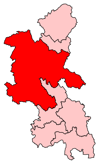
Buckingham is a market town in north Buckinghamshire, England, close to the borders of Northamptonshire and Oxfordshire, which had a population of 12,890 at the 2011 Census. The town lies approximately 10 miles (16 km) west of Central Milton Keynes, 16 miles (26 km) south-east of Banbury, and 21 miles (34 km) north-east of Oxford.
A hundred is an administrative division that is geographically part of a larger region. It was formerly used in England, Wales, some parts of the United States, Denmark, Southern Schleswig, Sweden, Finland, Norway, the Bishopric of Ösel–Wiek, Curonia, the Ukrainian state of the Cossack Hetmanate and in Cumberland County in the British Colony of New South Wales. It is still used in other places, including in Australia.
Buckingham is a constituency represented in the House of Commons of the UK Parliament since 2019 by Greg Smith, a Conservative.
Buckingham is an unincorporated community located near the intersections of Hwy D-65 and U.S. Highway 63 in Buckingham Township, Tama County, Iowa, United States. It lies 5.5 miles north of Traer and 11 miles south of Hudson. Buckingham is located at 42°15′45″N92°26′52″W.

Lands administrative divisions of Australia are the cadastral divisions of Australia for the purposes of identification of land to ensure security of land ownership. Most states term these divisions as counties, parishes, hundreds, and other terms. The eastern states of Queensland, New South Wales, Victoria, and Tasmania were divided into counties and parishes in the 19th century, although the Tasmanian counties were renamed land districts in the 20th century. Parts of South Australia (south-east) and Western Australia (south-west) were similarly divided into counties, and there were also five counties in a small part of the Northern Territory. However South Australia has subdivisions of hundreds instead of parishes, along with the Northern Territory, which was part of South Australia when the hundreds were proclaimed. There were also formerly hundreds in Tasmania. There have been at least 600 counties, 544 hundreds and at least 15,692 parishes in Australia, but there are none of these units for most of the sparsely inhabited central and western parts of the country.
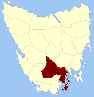
Buckingham Land District is one of the twenty land districts of Tasmania which are part of the Lands administrative divisions of Tasmania. It was formerly Buckingham County, one of the 18 counties of Tasmania and one of the first eleven proclaimed in 1836 and is bordered to the north by the River Derwent, and to the south by the Huon River. It includes Bruny Island. Hobart is located in the county. It was named after the then county of England.
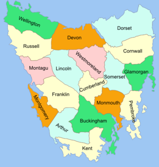
The Lands administrative divisions of Tasmania are the divisions of Tasmania into land districts and parishes for cadastral purposes, which are part of the lands administrative divisions of Australia. There are 20 land districts in Tasmania, although in the early nineteenth century there were several other systems, with 18 or 36 counties and 9 other divisions used, as well as hundreds. The land districts include the 18 former counties of the island of Tasmania which were renamed but retain the same boundaries, plus King Island and Flinders Island. The counties are referenced in the 1911 Encyclopædia Britannica, with Hobart described as being in Buckingham County, Launceston in Cornwall County and Beaconsfield in Devon County. The land districts are used for land titles today, while the Local Government Areas of Tasmania with cities and municipalities are used for political and administrative purposes.
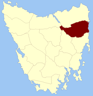
Cornwall Land District is one of the twenty land districts of Tasmania which are part of the Cadastral divisions of Tasmania. It contains most of Launceston. It was formerly Cornwall County, one of the 18 counties of Tasmania and one of the first eleven proclaimed in 1836. It was named after the then southwestern county of England.
Stoke Hundred is a hundred in Buckinghamshire, England. It is situated in the south of the county and is bounded on the east by Middlesex and on the south by Berkshire.

The District Council of Wirrega was a short-lived local government area in South Australia in existence from 1884 to 1888.
The District Councils Act 1887 was an act of the Parliament of South Australia. It received assent on 9 December 1887, and its provisions came into effect when proclaimed by Governor William C. F. Robinson on 5 January 1888.

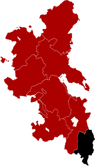
The County of Buckingham is one of the 49 cadastral counties of South Australia. It was proclaimed by Governor James Fergusson in 1869 and named for the third Duke of Buckingham and Chandos, Richard Temple-Nugent-Brydges-Chandos-Grenville who was appointed Secretary of State for the Colonies in 1867. It is located adjacent to the Victorian border in the state's upper south east. This includes most of the contemporary local government area of Tatiara District Council and a small east portion of Coorong District Council.
Willalooka is a small service town and locality in the Limestone Coast region of South Australia. it is located on the Riddoch Highway between Keith and Padthaway. Christmas Rocks Conservation Park is north of the town adjacent to the highway.
The Hundred of Senior is a Hundred of the County of Buckingham centered on the locality of Senior, South Australia.
The Hundred of Makin is a cadastral unit of hundred located in the Australian state of South Australia within the County of Buckingham and the state government region of the Limestone Coast about 210 kilometres (130 mi) south-east of the state capital of Adelaide and about 50 kilometres (31 mi) north-west and 120 kilometres (75 mi) south-east respectively of the municipal seats of Bordertown and Tailem Bend.
The Hundred of Stirling is a Hundred of the County of Buckingham, centered on Keith, South Australia, South east of Adelaide, South Australia.

The Hundred of McCallum is a cadastral hundred of the County of Buckingham, centered on the rural locality of McCallum and the Ngarkat area in South Australia. It was proclaimed by Governor Malcolm Barclay-Harvey in 1939 and named for Thomas McCallum, member of the South Australian parliament upper house and pastoral pioneer in the Ngarkat area.
The County of Chandos is one of the 49 cadastral counties of South Australia. It was proclaimed in 1893 and named by Governor Kintore for the Duke of Buckingham and Chandos, Richard Temple-Nugent-Brydges-Chandos-Grenville who was appointed Secretary of State for the Colonies in 1867. It covers a large portion of the southern Mallee region, adjacent to the state border with Victoria in the state's south east.

The District Council of Coonalpyn Downs was a local government area in the Australian state of South Australia that existed from 1957 to 1997 on land in the state’s south-east.
The Duke of Buckingham was Secretary of State for the Colonies. Area 1796 square miles.
| | This South Australia geography article is a stub. You can help Wikipedia by expanding it. |