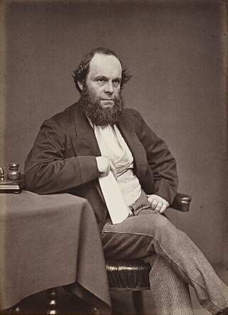
Richard Plantagenet Campbell Temple-Nugent-Brydges-Chandos-Grenville, 3rd Duke of Buckingham and Chandos,, styled Earl Temple until 1839 and Marquess of Chandos from 1839 to 1861, was a British soldier, politician and administrator of the 19th century. He was a close friend and subordinate of Benjamin Disraeli and served as the secretary of state for the colonies from 1867 to 1868 and governor of Madras from 1875 to 1880.

Keith is a town and a locality in the Australian state of South Australia located in the state's south-east about 225 kilometres (140 mi) from the state capital of Adelaide at the junction of the Dukes Highway and the Riddoch Highway. It is sometimes referred to as the 'lucerne capital of Australia' due to the high number of lucerne growers in the region.

Ngarkat Conservation Park is a protected area located in South Australia's south-eastern corner about 200 kilometres south east of the Adelaide city centre.

Tatiara District Council is a local government area located in south-eastern South Australia. The name Tatiara is said to mean "the good country", a phrase which dates back to the area's first inhabitants, the Bodaruwitj people. It is one of the largest local government areas in South Australia at 6,476 km2 (2,500 sq mi). The district's economy is based primarily on agriculture, with cereal crops such as wheat, barley and oats and with livestock such as sheep, cattle and pigs prominent.
Ngarkat is a locality in the Australian state of South Australia located in the south-east of the state at the border with the state of Victoria in both the Murray Mallee and the Limestone Coast regions about 227 kilometres south east of the state capital of Adelaide.

The District Council of Wirrega was a short-lived local government area in South Australia in existence from 1884 to 1888.
The District Councils Act 1887 was an act of the Parliament of South Australia. It received assent on 9 December 1887, and its provisions came into effect when proclaimed by Governor William C. F. Robinson on 5 January 1888.

The County of Cardwell is one of the 49 cadastral counties of South Australia. It was proclaimed by Governor Dominick Daly in 1864 and named for Edward Cardwell, 1st Viscount Cardwell, who was appointed Secretary of State for the Colonies in the same year. It is located south east of Lake Albert abutting the coastline along the southern portion of the Coorong coastal lagoon. This includes the southern half of the contemporary local government area of the Coorong District Council and smaller parts of the Tatiara District and Kingston District council areas.
Willalooka is a small service town and locality in the Limestone Coast region of South Australia. it is located on the Riddoch Highway between Keith and Padthaway. Christmas Rocks Conservation Park is north of the town adjacent to the highway.
Scorpion Springs Conservation Park was a protected area in the Australian state of South Australia located in the state’s south-east in the locality of Pinnaroo at the border with the state of Victoria about 215 kilometres (134 mi) south-east of the state capital of Adelaide and about 16 kilometres (9.9 mi) south of the town of Pinnaroo.
Sherwood is a locality in the Australian state of South Australia located about 222 kilometres (138 mi) south-east of the state capital of Adelaide and about 30 kilometres (19 mi) north-west of the municipal seat of Bordertown.

The Hundred of Tatiara is a Hundred of the County of Buckingham centered on Bordertown, and Wolseley, South Australia.
The Hundred of Makin is a cadastral unit of hundred located in the Australian state of South Australia within the County of Buckingham and the state government region of the Limestone Coast about 210 kilometres (130 mi) south-east of the state capital of Adelaide and about 50 kilometres (31 mi) north-west and 120 kilometres (75 mi) south-east respectively of the municipal seats of Bordertown and Tailem Bend.

The Hundred of Stirling is a Hundred of the County of Buckingham, centered on Keith, South Australia, South east of Adelaide, South Australia.
The Hundred of McCallum is a cadastral hundred of the County of Buckingham, centered on the rural locality of McCallum and the Ngarkat area in South Australia. It was proclaimed by Governor Malcolm Barclay-Harvey in 1939 and named for Thomas McCallum, member of the South Australian parliament upper house and pastoral pioneer in the Ngarkat area.
Makin is a locality in the Australian state of South Australia located on the state’s south-east about 208 kilometres (129 mi) south-east of the state capital of Adelaide and about 50 kilometres (31 mi) north-west of the municipal seat of Bordertown.
Christmas Rocks Conservation Park is a protected area located in the Australian state of South Australia in the locality of Willalooka about 224 kilometres (139 mi) south-east of the state capital of Adelaide and about 29 kilometres (18 mi) south of the town of Keith.
The County of Chandos is one of the 49 cadastral counties of South Australia. It was proclaimed in 1893 and named by Governor Kintore for the Duke of Buckingham and Chandos, Richard Temple-Nugent-Brydges-Chandos-Grenville who was appointed Secretary of State for the Colonies in 1867. It covers a large portion of the southern Mallee region, adjacent to the state border with Victoria in the state's south east.

