County of Albert

Last updated

Albert
South Australia
Waikerie, Riverland 5.JPG
View of Waikerie from Holder at the north of the county
Australia South Australia location map.svg
Red pog.svg
Albert
Coordinates 34°29′S140°00′E / 34.49°S 140.00°E / -34.49; 140.00
Established19 April 1860 [1]
Area2,194 km2 (847.1 sq mi)
LGA(s)
Lands administrative divisions around Albert:
Burra Young Hamley
Eyre
Sturt
Albert Alfred
Russell Buccleuch Chandos

The County of Albert is one of the 49 cadastral counties of South Australia on the east banks of the River Murray. It was proclaimed by Governor Richard MacDonnell in 1860 and named for Albert, Prince Consort of Queen Victoria. [2]

Contents

Hundreds

A few years before the county was proclaimed, the Hundred of the Murray had been established to control land use immediately adjacent the river. This was abolished in 1860 and the county was proclaimed along with the five western riverside hundreds of Cadell, Randell (now Murbko), Paisley, Cooper (now Nildottie), and Giles (now Forster). Eight further hundreds were proclaimed to incorporated the entire county by 1912.[ citation needed ]

The county is presently divided into hundreds as follows:

Local governance

The promulgation of the District Councils Act 1887 in January 1888 saw the hundred of Cadell form part of the new District Council of Morgan, the hundreds of Nildottie and Paisley form part of the new District Council of Blanchetown (later called Swan Reach), and the hundred of Forster added to the District Council of Caurnamont which had been established in 1885. A decade on, in 1898, the newly-gazetted hundreds of Murbko and Bakara were annexed by Blanchetown council.

In 1910 the hundred of Moorook was incorporated into the new District Council of Loxton. Then, in 1913, the hundred of Mantung, was incorporated into Blanchetown. [3] The following year, in 1914, the District Council of Waikerie was proclaimed as comprising the hundreds of Waikerie and Holder.

In 1923 the District Council of East Murray was proclaimed as comprising the hundreds of Bandon, Chesson, Mindarie and northern portions of southerly adjacent hundreds of Wilson and McPherson in the County of Buccleuch. This brought under local governance the only remaining lands in the county without local-level government.

In 1933, the hundred of Paisley was incorporated into the District Council of Waikerie and the hundred of Nildottie was incorporated into the new District Council of Keyneton and Swan Reach (later called Sedan). In 1935, the hundred of Forster was incorporated into the new District Council of Marne.

In 1976 Marne amalgamated with Sedan bringing the hundreds of Nildottie and Forster under the local governance of the new District Council of Ridley until 1991. From 1991 to 1997 they were governed the District Council of Ridley-Truro and from 1997 by the Mid Murray Council. Three years on, in 1979, the amalgamation of East Murry and Karoonda saw the southern hundreds of Bandon, Chesson and Mindarie (as well as southern parts of Bakara and Mantung) incorporated into the new District Council of Karoonda East Murray.

See also

Related Research Articles

<span class="mw-page-title-main">Mid Murray Council</span> Local government area in South Australia

The Mid Murray Council is a local government area in South Australia in the Murray and Mallee region of South Australia. The council spans the area from the Riverland through the Murraylands to the eastern slopes of the Mount Lofty Ranges. It includes 220 km of the Murray River. The council seat is at Mannum; it also maintains secondary offices at Cambrai and Morgan.

<span class="mw-page-title-main">District Council of Karoonda East Murray</span> Local government area in South Australia

The District Council of Karoonda East Murray is a local government area in the Murray Mallee area of South Australia. The main council offices are in Karoonda.

The Murray Mallee is the grain-growing and sheep-farming area of South Australia. It is bounded to the north and west by the Murray River, called the "River Murray" in South Australia, to the east by the Victorian border, and extending about 50 km south of the Mallee Highway.

<span class="mw-page-title-main">District Council of Loxton Waikerie</span> Local government area in South Australia

The District Council of Loxton Waikerie is a local government area in the Murray Mallee region of South Australia. The council seat lies at Loxton, while it maintains a branch office at Waikerie.

Nildottie is a locality in the Australian state of South Australia located on the east side of the Murray River about 99 kilometres (62 mi) east of the state capital of Adelaide and about 40 kilometres (25 mi) north-east of the municipal seat in Mannum.

The District Council of Loxton was a local government area in South Australia from 1910 to 1997, centring on the town of Loxton.

Copeville is a town and a locality in the Australian state of South Australia.

<span class="mw-page-title-main">Moorook, South Australia</span> Town in South Australia

Moorook is a town and locality in Australian state of South Australia. It is part of a series of towns surrounding lakes in the Riverland region in Australia. At the 2016 census, Moorook had a population of 189.

Mantung is a town and a locality in the Australian state of South Australia located in the state's south-east about 140 kilometres (87 mi) east of the state capital of Adelaide, and about 58 kilometres (36 mi) north-east and about 48 kilometres (30 mi) south-west respectively of the municipal seats of Karoonda and Loxton.

<span class="mw-page-title-main">District Council of Morgan</span> Local government area in South Australia

The District Council of Morgan was a local government area in South Australia from 1888 to 1997, centring on the town of Morgan.

The District Council of Ridley was a local government area in South Australia from 1976 to 1991.

The Hundred of the Murray was a cadastral hundred in South Australia spanning land two miles either side of the navigable portion of the Murray River in the 1850s and 1860s.

<span class="mw-page-title-main">Hundred of Forster</span> Cadastral in South Australia

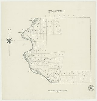
The Hundred of Forster, formerly the hundreds of Giles and Morphett, is a cadastral hundred in the County of Albert, South Australia.

The District Council of Swan Reach was a local government area in the Murraylands of South Australia from 1888 to 1933.

Mercunda is a town and a locality in the Australian state of South Australia located in the state's south-east about 134 kilometres (83 mi) east of the state capital of Adelaide, and about 52 kilometres (32 mi) north-east and about 53 kilometres (33 mi) south-west respectively of the municipal seats of Karoonda and Loxton.

The River News was a weekly newspaper published in Waikerie, South Australia, published from July 1956 until April 2020.

The County of Alfred is one of the 49 cadastral counties of South Australia on the south banks of the River Murray. It was proclaimed by Governor James Fergusson in 1868 and named for Prince Alfred, second son of Queen Victoria, who visited the state in 1867.

<span class="mw-page-title-main">John Percival Jennings</span> Australian horticulturalist (1923–2003)

John Percival Jennings was an Australian horticulturalist who was a senior adviser for the South Australian Department of Agriculture.

References

  1. "Proclamation" (PDF). South Australian Government Gazette . Government of South Australia. 1860 (16): 339. 19 April 1860. Retrieved 3 December 2018.
  2. "Placename Details: County of Albert". Property Location Browser. Government of South Australia. 14 January 2009. SA0000592. Archived from the original on 7 December 2015. Retrieved 4 December 2017.
  3. "MANTUNG". Daily Herald . Vol. 4, no. 1013. South Australia. 20 June 1913. p. 8. Retrieved 16 April 2019 via National Library of Australia. June 16—This hundred has been declared a ward in the Blanchetown District Council.