The Murray Mallee is the grain-growing and sheep-farming area of South Australia. It is bounded to the north and west by the Murray River, called the "River Murray" in South Australia, to the east by the Victorian border, and extending about 50 km south of the Mallee Highway.
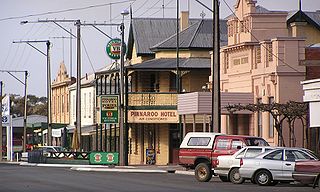
Pinnaroo is a town in the Murray Mallee region of South Australia, near the border with Victoria, 243 km east of Adelaide. Pinnaroo is on the north side of the Mallee Highway, and on the railway line between Tailem Bend and Ouyen. The roadhouse on the highway at Pinnaroo is the first "food and leg-stretch" stop on the bus route from Adelaide to Sydney.
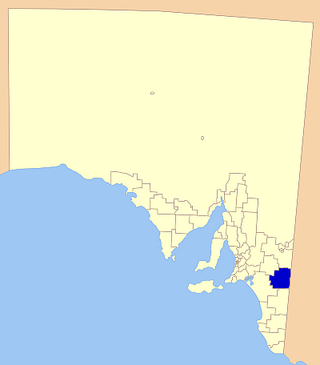
The Southern Mallee District Council is a local government area in the Murray and Mallee region of South Australia. The council offices are in Pinnaroo and Lameroo. It was established on 23 January 1997 when the District Council of Lameroo and District Council of Pinnaroo agreed to merge. Their predecessors date from 1908.
Parilla is a town and a locality in the Australian state of South Australia located in the state's Murray Mallee region about 192 kilometres (119 mi) east of the state capital of Adelaide, about 32 kilometres (20 mi) west of the municipal seat of Pinnaroo and about 14 kilometres (8.7 mi) east of the town of Lameroo.
Lameroo is a town in the Murray Mallee region of South Australia. It is on the Mallee Highway and Pinnaroo railway line about 40 km west of the Victorian border, or 210 km east of Adelaide. It is primarily a service town for the surrounding rural areas, growing grain and sheep. Lameroo now includes the former settlements of Kulkami, Mulpata, Wirha and Gurrai, which were on the Peebinga railway line, and Wilkawatt, which was between Parrakie and Lameroo on the Pinnaroo railway.

The Mallee Football League (MFL) was an Australian rules football competition in South Australia. The league comprised teams located in south eastern South Australia and one team (Murrayville) located in western Victoria.

Ngarkat Conservation Park is a protected area located in South Australia's south-eastern corner about 200 kilometres south east of the Adelaide city centre.
The Border Times, based in Pinnaroo, is the local newspaper of the Southern Mallee region of South Australia since 1911. Published weekly, it focuses on local news, sports and weather.

Parrakie, South Australia is a small town on the Mallee Highway and Pinnaroo railway line approximately 26 kilometres west of Lameroo. The name is derived from the Aboriginal word perki which means cave or limestone sink hole. The town was surveyed in 1907.

Peebinga Conservation Park is a 34 km2 protected area lying 40 km north of the town of Pinnaroo in the Murray Mallee region of south-eastern South Australia, about 240 km east of Adelaide and 10 km west of the Victorian border.
Victoria and Albert was an electoral district in the South Australian House of Assembly from 1902 to 1915. The seat elected candidates of both major parties at various times. It merged the seats of Victoria and Albert, which were both recreated on its abolition.
Albert was an electoral district of the House of Assembly in South Australia, spanning its time as both a colony and a state. It was created in 1875, taking much territory from adjacent Victoria, merged with Victoria in 1902 as Victoria and Albert, separated again in 1915, and abolished in 1970.
The Peebinga railway line was a railway line on the South Australian Railways network. It opened on 28 December 1914 from a junction with the Barmera line at Karoonda and ran generally eastward through the Murray Mallee terminating at Peebinga, two kilometres from the Victorian state border. It closed on 7 December 1990.
Ngarkat is a locality in the Australian state of South Australia located in the south-east of the state at the border with the state of Victoria in both the Murray Mallee and the Limestone Coast regions about 227 kilometres south east of the state capital of Adelaide.

The County of Buckingham is one of the 49 cadastral counties of South Australia. It was proclaimed by Governor James Fergusson in 1869 and named for the third Duke of Buckingham and Chandos, Richard Temple-Nugent-Brydges-Chandos-Grenville who was appointed Secretary of State for the Colonies in 1867. It is located adjacent to the Victorian border in the state's upper south east. This includes most of the contemporary local government area of Tatiara District Council and a small east portion of Coorong District Council.
Scorpion Springs Conservation Park was a protected area in the Australian state of South Australia located in the state’s south-east in the locality of Pinnaroo at the border with the state of Victoria about 215 kilometres (134 mi) south-east of the state capital of Adelaide and about 16 kilometres (9.9 mi) south of the town of Pinnaroo.
The Ngarkat is a recorded title of a tribal group from South Australia. The Ngarkat lands had linked the mallee peoples of Victoria and South Australia to the river peoples of the Murray River Murraylands. Ngarkat language has been loosely grouped with Peramangk language though not by linguists, and the grouping was perhaps partly owed to the co-ownership of lands in both the Ninety Mile Desert and Echunga by John Barton Hack, and partly to the occasional meeting of tribes. The language of the Ngarkat was recorded as being Boraipur by Ryan in recent times though sources were not given, while it may yet be telling that the citing work concerns Mallee peoples to the east. The language may have been midway between that of mallee peoples to the east, and that of peoples to the west recorded by Teichelmann and Schurman. It is known that songlines linked the Coorong to the Mallee regions, hence went through Ngarkat land. It is also known that Ngarkat people did meet regularly with tribes to the east, at sites along the Murray.
Karte Conservation Park is a protected area located in the Australian state of South Australia in the localities of Karte and Parilla about 193 kilometres (120 mi) east of the state capital of Adelaide and about 26 kilometres (16 mi) north-west of the town of Pinnaroo.
Kringin is a town and a locality in the Australian state of South Australia located in the state’s east about 199 kilometres (124 mi) east of the state capital of Adelaide and about 61 kilometres (38 mi) south of the municipal seat of Loxton.
Karte is a town and a locality in the Australian state of South Australia located in the state’s east about 192 kilometres (119 mi) east of the state capital of Adelaide, about 30 kilometres (19 mi) north-west of the municipal seat of Pinnaroo and about 35 kilometres (22 mi) north-east of the town of Lameroo.

