Related Research Articles

Field Marshal Edmund Henry Hynman Allenby, 1st Viscount Allenby, was a senior British Army officer and Imperial Governor. He fought in the Second Boer War and also in World War I, in which he led the British Empire's Egyptian Expeditionary Force (EEF) during the Sinai and Palestine Campaign against the Ottoman Empire in the conquest of Palestine.

Robert Allenby is an Australian professional golfer.

Lands administrative divisions of Australia are the cadastral divisions of Australia for the purposes of identification of land to ensure security of land ownership. Most states term these divisions as counties, parishes, hundreds, and other terms. The eastern states of Queensland, New South Wales, Victoria, and Tasmania were divided into counties and parishes in the 19th century, although the Tasmanian counties were renamed land districts in the 20th century. Parts of South Australia (south-east) and Western Australia (south-west) were similarly divided into counties, and there were also five counties in a small part of the Northern Territory. However South Australia has subdivisions of hundreds instead of parishes, along with the Northern Territory, which was part of South Australia when the hundreds were proclaimed. There were also formerly hundreds in Tasmania. There have been at least 600 counties, 544 hundreds and at least 15,692 parishes in Australia, but there are none of these units for most of the sparsely inhabited central and western parts of the country.
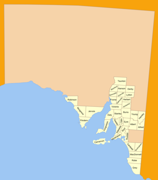
The lands administrative divisions of South Australia are the cadastral units of counties and hundreds in South Australia. They are located only in the south-eastern part of the state, and do not cover the whole state. 49 counties have been proclaimed across the southern and southeastern areas of the state historically considered to be arable and thus in need of a cadastre. Within that area, a total of 540 hundreds have been proclaimed, although five were annulled in 1870, and, in some cases, the names reused elsewhere.

Allenby Gardens is a western suburb of Adelaide, South Australia. It is located in the City of Charles Sturt.

The County of Flinders is one of the 49 cadastral counties of South Australia. The county covers the southern part of the Eyre Peninsula “bounded on the north by a line connecting Point Drummond with Cape Burr, and on all other sides by the seacoast, including all islands adjacent to the main land.”

The County of Robinson is one of the 49 counties of South Australia. It was proclaimed in 1883 by Governor William Robinson who named it after himself. It lies on the north west coast of Eyre Peninsula stretching from Streaky Bay inland to include the Gawler Ranges Conservation Park at the southern cusp of the Gawler Ranges.

County of Carnarvon is a cadastral unit located in the Australian state of South Australia which covers the full extent of Kangaroo Island. It was proclaimed in 1874 by Governor Musgrave in response to the demand for agriculture land on Kangaroo Island.
Allenby is a neighbourhood of Toronto, Ontario, Canada. It is a primarily residential neighbourhood within the boundaries of Latimer Avenue to the west, Briar Hill Avenue to the north, Avenue Road to the east and Eglinton Avenue West to the south.

The County of Grey is one of the 49 cadastral counties of South Australia. It was proclaimed in 1846 by Governor Frederick Robe and named for former Governor George Grey. It covers the extreme south-east of the state from Penola and Lake George southwards. This includes the following contemporary local government areas of the state:

The County of Russell is one of the 49 cadastral counties in South Australia. It was proclaimed in 1842 by Governor George Grey and named for Lord John Russell, who was involved in the early development of the (British) South Australian colony when he was Secretary of State for War and the Colonies. It covers a portion of the state bounded to the west by the eastern half of Lake Alexandrina and the section of the Murray River extending to Bowhill in the north and bounded to the south by the coastline adjoining the Coorong coastal lagoon and fully surrounds Lake Albert which is excluded from its extent. This includes the north western quarter of the contemporary local government area of Coorong District Council.

County of Fergusson is a cadastral unit located in the Australian state of South Australia which spans Yorke Peninsula south of Price. It was proclaimed in 1869 by Governor Fergusson after whom the county was named.

County of Burra is a cadastral unit located in the Australian state of South Australia which covers land located in the state’s east associated with the town of Burra. It was proclaimed in 1851 by Governor Young and named after the town of Burra.
The County of Musgrave is a cadastral unit in the Australian state of South Australia that covers land on the west coast of Eyre Peninsula. It was proclaimed on 22 June 1876 and named after Anthony Musgrave, the Governor of South Australia from 9 June 1876 to 29 January 1877.
Kulliparu Conservation Park is a protected area in the Australian state of South Australia located on the Eyre Peninsula in the gazetted localities of Colley, Karcultaby, Mount Cooper and Mount Damper about 59 kilometres (37 mi) west of the town centre in Kyancutta.

County of Le Hunte is a cadastral unit located in the Australian state of South Australia that covers land located in the centre of Eyre Peninsula. It was proclaimed in 1908 and named after George Le Hunte who was the Governor of South Australia from July 1903 to February 1909.

County of Buxton is a cadastral unit located in the Australian state of South Australia that covers land located in the centre of Eyre Peninsula. It was proclaimed in 1896 and named after Thomas Buxton who was the Governor of South Australia from 29 October 1895 to 29 March 1899. It has been divided into thirteen sub-divisions known as hundreds, with the most recent being created in 1928.

The County of Jervois is a cadastral unit in the Australian state of South Australia that covers land on the east coast of the Eyre Peninsula. It was proclaimed on 24 January 1878 and named after William Jervois, the Governor of South Australia from October 1877 to January 1883.
The County of Victoria is one of the 49 cadastral counties of South Australia. It was proclaimed by Governor Richard MacDonnell in 1857 and probably named for Queen Victoria. It covers an area of the Spencer Gulf coast and hinterland in the Mid North of the state from Port Pirie in the northwest to near Mount Bryan in the southeast, including most of the Broughton River watershed.
The County of Chandos is one of the 49 cadastral counties of South Australia. It was proclaimed in 1893 and named by Governor Kintore for the Duke of Buckingham and Chandos, Richard Temple-Nugent-Brydges-Chandos-Grenville who was appointed Secretary of State for the Colonies in 1867. It covers a large portion of the southern Mallee region, adjacent to the state border with Victoria in the state's south east.
References
- 1 2 Leadbeater, Maureen M (5 June 2016). "Counties and Hundreds – South Australia". FamilyHistorySA.info. Retrieved 19 July 2016.
- ↑ "Counties and hundreds of South Australia". fleurieufamilyhistory.org. Retrieved 24 January 2024.
- ↑ "Pinnaroo". Walkabout. Fairfax Media. Archived from the original on 29 October 2005. Retrieved 7 July 2007.
| | This South Australia geography article is a stub. You can help Wikipedia by expanding it. |