
Snowtown is a town located in the Mid North of South Australia 145 km north of Adelaide and lies on the main road and rail routes between Adelaide and Perth – the Augusta Highway and Adelaide-Port Augusta railway line. The town's elevation is 103 metres and on average the town receives 389 mm of rainfall per annum.

The Barunga West Council is a local government area in the Yorke and Mid North region of South Australia. The council seat is at Port Broughton, with a sub-office at Bute.

Paskeville is a town on South Australia's Yorke Peninsula. It is located approximately 20 km east of Kadina on the Copper Coast Highway towards Adelaide. At the 2016 census, Paskeville had a population of 178. The town's district is administratively divided between the Copper Coast Council and the District Council of Barunga West.

Bute is a town in the Northern Yorke peninsula of South Australia, approximately 40 kilometres (25 mi) east of Wallaroo and 24 kilometres west of Snowtown. It was proclaimed as a town in 1884 and named after the Isle of Bute, in the Firth of Clyde, Scotland. It was the original site of the Yorke Peninsula Field Days in 1895; they are now held outside Paskeville.
Alford is a settlement in South Australia. Alford is in the Hundred of Tickera, northern Yorke Peninsula, about midway between the towns of Kadina and Port Broughton. The natural landform is undulating fertile plains, which often feature limestone and dunes. Founded on the agricultural industry, which surrounds the township, most of the original mallee scrub vegetation has been cleared for highly productive broad-acre wheat and barley farming, plus grazing and mixed farming.
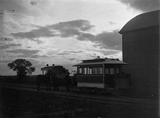
Mundoora is a settlement in South Australia, 16 km inland from Port Broughton, to which it was connected by the horse-drawn Port Broughton tramway around 1876. Its tram, dubbed "The Pie Cart", which was described as a "kind of second-hand coffin drawn by one horse" and still in operation in 1923 was later relegated to the Railways Museum and the line dismantled.
Young was an electoral district of the House of Assembly in the Australian state of South Australia from 1938 to 1956.
Ninnes is a locality at the northeastern corner of Yorke Peninsula and western side of the Mid North of South Australia. It lies where the Upper Yorke Road from Kulpara to Bute is crossed by the road from Paskeville to Lochiel. The dominant industry is broadacre grain and sheep farming.

The Hundred of Barunga is a cadastral unit of hundred located in the Mid North of South Australia on the approximate area of the Barunga Range, centred on Bald Hill. It is one of the 16 hundreds of the County of Daly. It was named in 1869 by Governor James Fergusson after an indigenous term meaning gap in the range. See Barunga Range § Etymology
The District Council of Port Broughton was a local government area in South Australia from 1892 to 1997 seated at the town of Port Broughton.
The District Council of Bute was a local government area in South Australia from 1885 to 1997.
The District Council of Green's Plains was a local government area in South Australia from 1871 to 1888. It was the first local government on the Yorke Peninsula.
Clements Gap Conservation Park is a protected area located in the Mid North of South Australia about 15 kilometres (9.3 mi) west of Redhill, 20 kilometres (12 mi) north east of Port Broughton and 42 metres above sea level. The park preserves an area of natural bushland and the built remnants of a small historic agricultural township, Clements Gap, about 12 kilometres (7.5 mi) east of the Spencer Gulf coast. Maintained by the South Australian Department of Environment, Water and Natural Resources (DEWNR), the park is classified as an IUCN Category III Natural Monument or Feature. The park is named for the surrounding farming locality of Clements Gap, a reference to the co-located pass through the Barunga Range. The Clements Gap pass in turn is thought to be named after a shepherd in the area prior to 1880, per research by local historian Rodney Cockburn.

Barunga Gap is a locality in South Australia about 12 kilometres (7.5 mi) south west of Snowtown. Barunga Gap was named in reference to the co-located pass between the Barunga Range to the north and Hummock Range to the south. The word 'Barunga' derives from an indigenous term meaning "gap in the range". See Barunga Range § Etymology
The District Council of Snowtown was a local government area in South Australia from 1888 to 1987.
The Hundred of Redhill is a cadastral unit of hundred located in the Mid North of South Australia spanning the northern Barunga Range. It is one of the 16 hundreds of the County of Daly and was named in 1869 by Governor James Fergusson after the same hill giving rise to the name for the township of Redhill, uphill from the west bank of the Broughton River.

The Hundred of Kadina is a cadastral unit of hundred located on the north-western Yorke Peninsula in South Australia. It is one of the 16 hundreds of the County of Daly and was proclaimed by Governor Dominick Daly on 12 June 1862.

The Hundred of Kulpara is a cadastral unit of hundred located on the northern Yorke Peninsula in South Australia and centred on the township of Kulpara. It is one of the 16 hundreds of the County of Daly and was proclaimed by Governor Dominick Daly on 12 June 1862.

The Hundred of Wiltunga is a cadastral unit of hundred located in the Mid North of South Australia west of the Barunga Range. It is one of the 16 hundreds of the County of Daly and was proclaimed by Governor Anthony Musgrave on the last day of 1874.

The Hundred of Wokurna is a cadastral unit of hundred located in the Mid North of South Australia west of the Barunga Range. It is one of the 16 hundreds of the County of Daly and was proclaimed by Governor Anthony Musgrave on the last day of 1874.

