Ninnes, South Australia

Last updated

Ninnes
South Australia
Australia South Australia location map.svg
Red pog.svg
Ninnes
Coordinates 33°58′13″S138°01′11″E / 33.9703°S 138.0198°E / -33.9703; 138.0198 Coordinates: 33°58′13″S138°01′11″E / 33.9703°S 138.0198°E / -33.9703; 138.0198
Postcode(s) 5560
Location
LGA(s) District Council of Barunga West
State electorate(s) Narungga [1]
Federal Division(s) Grey
Localities around Ninnes:
Bute
Thomas Plain Ninnes Lochiel
Paskeville Kulpara South Hummocks

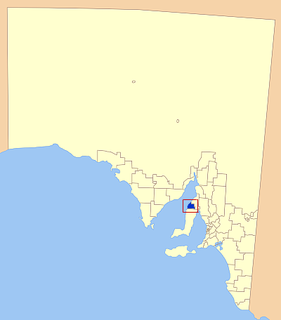
Ninnes is a locality at the northeastern corner of Yorke Peninsula and western side of the Mid North of South Australia. It lies where the Upper Yorke Road from Kulpara to Bute is crossed by the road from Paskeville to Lochiel. The dominant industry is broadacre grain and sheep farming.

Yorke Peninsula Region in South Australia

The Yorke Peninsula is a peninsula located north-west and west of Adelaide in South Australia, between Spencer Gulf on the west and Gulf St Vincent on the east. The peninsula is separated from Kangaroo Island to the south by Investigator Strait. The most populous town in the region is Kadina.

Mid North region of South Australia

The Mid North is a region of South Australia, north of the Adelaide Plains, but not as far north as the Far North, or the outback. It is generally accepted to extend from Spencer Gulf east to the Barrier Highway, including the coastal plain, the southern part of the Flinders Ranges, and the northern part of the Mount Lofty Ranges. The area was settled as early as 1840 and provided early farming and mining outputs for the fledgling colony. Farming is still significant in the area, particularly wheat, sheep and grapevines. There are not currently any significant mining activities in the Mid North.

South Australia State of Australia

South Australia is a state in the southern central part of Australia. It covers some of the most arid parts of the country. With a total land area of 983,482 square kilometres (379,725 sq mi), it is the fourth-largest of Australia's states and territories by area, and fifth largest by population. It has a total of 1.7 million people, and its population is the second most highly centralised in Australia, after Western Australia, with more than 77 percent of South Australians living in the capital, Adelaide, or its environs. Other population centres in the state are relatively small; Mount Gambier, the second largest centre, has a population of 28,684.

History

The area of Ninnes Plain was settled by the early 1860s and the Hundred of Ninnes was proclaimed in 1874.

Hundred of Ninnes Cadastral in South Australia

The Hundred of Ninnes is a cadastral unit of hundred located in the Mid North of South Australia centred on the Ninnes Plain. It is one of the 16 hundreds of the County of Daly and was proclaimed by Governor Anthony Musgrave on the last day of 1874.

In 1976 a bushfire started in the Hummock Range and tore westwards through Ninnes Plain towards Green Plain, near the present-day township of Paskeville. [2] According to local reportage at the time the fire was so fierce that the townships of Wallaroo and Kadina, more than 15 to 20 km (9.3 to 12.4 mi) distant, were illuminated at night by the fire's glow. [2]

Hummock Range Range of hills in the northern Mount Lofty Ranges, South Australia

The Hummocks or Hummock Range is a range of hills in the northern Mount Lofty Ranges extending north from the eastern edge of Yorke Peninsula in South Australia. It is traversed by the Copper Coast Highway immediately west of where it passes around the northern end of Gulf St Vincent. The Augusta Highway passes to the east of the Hummocks. The Hummock Range includes the settlements of South Hummocks and Kulpara. Towards the range's northern end it continues as the Barunga Range north of Barunga Gap, approximately 10 kilometres (6.2 mi) south west of Snowtown.

Paskeville, South Australia Town in South Australia

Paskeville is a town on South Australia's Yorke Peninsula. It is located approximately 20 km east of Kadina on the Copper Coast Highway towards Adelaide. At the 2016 census, Paskeville had a population of 178. The town's district is administratively divided between the Copper Coast Council and the District Council of Barunga West.

Wallaroo, South Australia Town in South Australia

Wallaroo is a port town on the western side of Yorke Peninsula in South Australia, 160 kilometres (100 mi) northwest of Adelaide. It is one of the three Copper Triangle towns famed for their historic shared copper mining industry, and known together as "Little Cornwall", the other two being Kadina, about 8 kilometres (5 mi) to the east, and Moonta, about 18 kilometres (11 mi) south. In 2015, Wallaroo had an estimated population of 4,010.

The District Council of Ninnes was established in 1885 and adopted a former accommodation house as a council chamber. The council chamber would also be used as a school until a separate building was constructed six years later. [3]

Ninnes Post Office opened on 1 November 1882; its date of closure is unknown. [4]

In 1910, it was reported that "while Ninnes...cannot claim to have built a town, and it is easy to count its public buildings, it is not backward in other things", citing the "substantially built and commodious homesteads" and that as one of "the outlying districts which support the towns, it is enjoying prosperity". The council seat subsequently moved to Bute, which had far outgrown Ninnes, and the council was renamed Bute in 1933. [3]

Bute, South Australia Town in South Australia

Bute is a town in the Mid North of South Australia, approximately 40 kilometres (25 mi) east of Wallaroo and 24 kilometres west of Snowtown. It was proclaimed as a town in 1884 and named after the Isle of Bute, in the Firth of Clyde, Scotland. It was the original site of the Yorke Peninsula Field Days in 1895; they are now held outside Paskeville.

The modern locality of Ninnes was established in 1998 when boundaries were formalised for "the long established local name". An additional area within Wakefield Regional Council was added to the locality in 2000, but removed and added to Lochiel in 2007 following requests from local residents. [5]

Related Research Articles

District Council of Barunga West Local government area in South Australia

The District Council of Barunga West is a local government area in the Yorke and Mid North region of South Australia. The council seat is at Port Broughton, with a sub-office at Bute.

Kadina, South Australia Town in South Australia

Kadina is a town on the Yorke Peninsula of the Australian state of South Australia, approximately 144 kilometres north-northwest of the state capital of Adelaide. The largest town of the Peninsula, Kadina is one of the three Copper Triangle towns famous for their shared copper mining history. The three towns are known as "Little Cornwall" for the significant number of immigrants from Cornwall who worked at the mines in the late 19th century.

The Yorke Peninsula Football League (YPFL) is an Australian rules football competition based in the Yorke Peninsula region of South Australia, Australia. It is an affiliated member of the South Australian National Football League. The league was known as the Yorke Valley Football League until 1996, having previously absorbed the Yorke Peninsula Football Association in 1961, and the Southern Yorke Peninsula Football League in 1994.

Lochiel, South Australia Town in South Australia

Lochiel is a small town in the Mid North of South Australia 125 km north of Adelaide. The town lies beside on the western edge of Lake Bumbunga and at the eastern foot of the Hummocks Range. The Augusta Highway, a section of Highway 1, runs on a strip between the township and the lake, which dwarves the former.

Copper Coast Council Local government area in South Australia

The Copper Coast Council is a local government area in the Australian state of South Australia located at the northern end of the Yorke Peninsula. It was established in 1997 and its seat is in Kadina.

Alford, South Australia Town in South Australia

Alford is a settlement in South Australia. Alford is in the Hundred of Tickera, northern Yorke Peninsula, about midway between the towns of Kadina and Port Broughton. The natural landform is undulating fertile plains, which often feature limestone and dunes. Founded on the agricultural industry, which surrounds the township, most of the original mallee scrub vegetation has been cleared for highly productive broad-acre wheat and barley farming, plus grazing and mixed farming.

Young was an electoral district of the House of Assembly in the Australian state of South Australia from 1938 to 1956.

County of Daly Cadastral in South Australia

The County of Daly is one of the 49 cadastral counties of South Australia. It was proclaimed in 1862 and named for Governor Dominick Daly. It covers the northern half of Yorke Peninsula stretching just east of the Hummock-Barunga Range in the west and just past the Broughton River in the north.

The Balaklava-Moonta railway line was a railway line on the South Australian Railways network. It ran across the top of the Yorke Peninsula.

District Council of Bute Local government area in South Australia

The District Council of Bute was a local government area in South Australia from 1885 to 1997.

District Council of Northern Yorke Peninsula former local government area of South Australia

The District Council of Northern Yorke Peninsula was a local government area in South Australia from 1984 to 1997. The council seat was at Kadina.

District Council of Kadina

The District Council of Kadina was a local government area in South Australia from 1888 to 1984.

District Council of Greens Plains

The District Council of Green's Plains was a local government area in South Australia from 1871 to 1888. It was the first local government on the Yorke Peninsula.

Hundred of Kadina Cadastral in South Australia

The Hundred of Kadina is a cadastral unit of hundred located on the north-western Yorke Peninsula in South Australia. It is one of the 16 hundreds of the County of Daly and was proclaimed by Governor Dominick Daly on 12 June 1862.

Hundred of Kulpara Cadastral in South Australia

The Hundred of Kulpara is a cadastral unit of hundred located on the northern Yorke Peninsula in South Australia and centred on the township of Kulpara. It is one of the 16 hundreds of the County of Daly and was proclaimed by Governor Dominick Daly on 12 June 1862.

References

  1. Narungga (Map). Electoral District Boundaries Commission. 2016. Retrieved 1 March 2018.
  2. 1 2 "The Wallaroo Times". The Wallaroo Times And Mining Journal . XII (1, 237). Wallaroo, South Australia. 16 December 1876. p. 2. Retrieved 8 November 2017 via National Library of Australia. During the past fortnight a tremendous bush fire has been raging near the Hummocks. It commenced somewhere on Ninnes's Plains, near the Clare track, and the fierce wind that was blowing at the time caused it to cross that track, and ignited on to the Barunga track, which it also crossed, and burnt through the whole of that extensive belt of scrub, right down to within a short distance of the Mail Station, at Green's Plains. [...] Wallaroo and Kadina were beautifully illuminated with the reflection of the burning mass, and the sky presented a lurid appearance.
  3. 1 2 "THE NINNES DISTRICT". The Kadina And Wallaroo Times . XLV, (5282). South Australia. 10 August 1910. p. 3. Retrieved 29 April 2016 via National Library of Australia.
  4. "Ninnes". Premier Postal. Post Office Reference. Retrieved 29 April 2016.
  5. "Placename Details: Ninnes". Property Location Browser. Government of South Australia. 23 September 2008. SA0049919. Retrieved 29 December 2015.