Related Research Articles

The Three Sisters are the three main agricultural crops of various indigenous people of Central and North America: squash, maize ("corn"), and climbing beans. In a technique known as companion planting, the maize and beans are often planted together in mounds formed by hilling soil around the base of the plants each year; squash is typically planted between the mounds. The cornstalk serves as a trellis for climbing beans, the beans fix nitrogen in their root nodules and stabilize the maize in high winds, and the wide leaves of the squash plant shade the ground, keeping the soil moist and helping prevent the establishment of weeds.
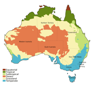
Although Australia is mostly arid, the nation is a major agricultural producer and exporter, with over 325,300 people employed in agriculture, forestry and fishing as of February 2015. Agriculture and its closely related sectors earn $155 billion a year for a 12% share of GDP. Farmers and grazers own 135,997 farms, covering 61% of Australia's landmass. Across the country, there is a mix of irrigation and dry-land farming. The success of Australia in becoming a major agricultural power despite the odds is facilitated by its policies of long-term visions and promotion of agricultural reforms that greatly increased the country's agricultural industry.
The Australian Bureau of Agricultural and Resource Economics and Sciences (ABARES) is a federal research branch of the Australian Government Department of Agriculture, Water and the Environment, located in Canberra, Australia. ABARES was established on 21 August 1945 as the Bureau of Agricultural Economics (BAE), and is also involved in commercial consultancy. It was merged with the Bureau of Rural Sciences (BRS) in 2010. The main role of ABARES is to provide "professionally independent data, research, analysis and advice that informs public and private decisions affecting Australian agriculture, fisheries and forestry”. ABARES maintains the AgSurf database which includes farm survey data on farm performance, production benchmarks, farm management, socioeconomic indicators relating to the grains, beef, sheep and dairy industries in Australia. ABARES has received funding from business and industry groups. ABARES' website notes that "Over half of ABARES' external revenue is derived from commercial consulting work."

This article details the history of Adelaide from the first human activity in the region to the 20th century. Adelaide is a planned city founded in 1836 and the capital of South Australia.

The Ord River is a 651-kilometre long (405 mi) river in the Kimberley region of Western Australia. The river's catchment covers 55,100 square kilometres (21,274 sq mi).
Moore River (Garban) is a river in the Wheatbelt region of Western Australia.

Kondinin is a town located in the eastern Wheatbelt region of Western Australia, 279 kilometres (173 mi) east of the state capital, Perth via the Brookton Highway and State Route 40 between Corrigin and Hyden. It is one of three towns in the Shire of Kondinin. At the 2006 census, Kondinin had a population of 311.

Mallee are trees or shrubs, mainly certain species of eucalypts, which grow with multiple stems springing from an underground lignotuber, usually to a height of no more than 10 m (33 ft). The term is widely used for trees with this growth habit across southern Australia, in the states of Western Australia, South Australia, New South Wales and Victoria, and has given rise to other uses of the term, including the ecosystems where such trees predominate, specific geographic areas within some of the states and as part of various species' names.

Seaford Rise is a metropolitan suburb of Adelaide, South Australia. It lies within the City of Onkaparinga. Its boundaries are formed by Griffiths Drive in the north, Commercial Road in the west, Main South Road in the east, and by an arbitrary border with Maslin Beach in the south.
Stansbury is a small town, located in the southern east coast of Yorke Peninsula, South Australia. It is located 25 kilometres (16 mi) south of Minlaton and 22 kilometres (14 mi) east of Yorketown. It faces the Gulf St Vincent across Oyster Bay, where shellfish were originally harvested in the 19th century. The town has also been a port used in the export of wheat and barley to Adelaide.
Lucky Lake is a village in the Canadian province of Saskatchewan within the Rural Municipality of Canaan No. 225 and Census Division No. 7. The Village is located at the junction of Highway 42, Highway 45 and Highway 646 approximately 90 km northeast of Swift Current, Saskatchewan.

Senador Modestino Gonçalves is a Brazilian municipality in the state of Minas Gerais.
Agricultural land is typically land devoted to agriculture, the systematic and controlled use of other forms of life—particularly the rearing of livestock and production of crops—to produce food for humans. It is generally synonymous with both farmland or cropland, as well as pasture or rangeland.
The commune Itaba is one of 11 municipalities in the province of Gitega, Burundi. It is surrounded in the north by the town of Gitega, to the south by Rutana Province, to the west by the municipalities Bukirasazi and Makebuko, and to the east also by Rutana Province, as well as Ruyigi Province. It covers an area of 170 square kilometres (66 sq mi), equal tp 8.6% of the entire province of Gitega and 0.6% of the whole country.
Eringa Station is a pastoral lease that operates as a cattle station in the outback of South Australia, once owned by Sir Sidney Kidman. Its land is gazetted as a locality called Eringa in 2013.
White Hut is a locality in the Australian state of South Australia. It is on the west coast of Yorke Peninsula immediately adjoining Spencer Gulf about 145 kilometres west of the state capital of Adelaide. Its boundaries were created in May 1999. As of 2014, the majority of the land within the locality is zoned as “water protection” to protect groundwater basins present at “shallow depths” and to encourage land use such as “broadacre cropping, grazing, and wind farm and ancillary development.” White Hut is within the federal division of Grey, the state electoral district of Narungga and the local government area of the Yorke Peninsula Council.
The Pines is a locality in the Australian state of South Australia located on the western side of Yorke Peninsula on the portion forming the south coast of Hardwicke Bay in Spencer Gulf about 131 kilometres west of the Adelaide city centre.
Woolpunda is a locality in the Riverland region of South Australia. It is on the south side of the Sturt Highway west of Kingston on Murray. The Woolpunda irrigation scheme was established in the 1920s in the northwestern part of the Hundred of Moorook.
Merilup is a locality in the Wheatbelt region of Western Australia, 309 kilometres (192 mi) south-east of Perth between Dumbleyung and Lake Grace just south of Kukerin. The construction of three schools was scattered for use within the area between 1922 and December 1950 when the final school was closed and consolidated in Kukerin's school. The population of Merilup live within private farm house dwellings scattered within the locality's boundaries, living and working on farms managing live stock and producing a range of broadacre crops. Today the area relies on the townsite of Kukerin, from which it shares a postcode, for essential services such as groceries and postage. At the 2021 census, Merilup had a population of 13.
Nippering is a locality in the Wheatbelt region of Western Australia within the Shire of Dumbleyung.