Wakefield Regional Council is a local government area in the Yorke and Mid North region of South Australia. The council seat is at Balaklava.

The Barunga West Council is a local government area in the Yorke and Mid North region of South Australia. The council seat is at Port Broughton, with a sub-office at Bute.

Kadina is a town on the Yorke Peninsula of the Australian state of South Australia, approximately 144 kilometres north-northwest of the state capital of Adelaide. The largest town of the Peninsula, Kadina is one of the three Copper Triangle towns famous for their shared copper mining history. The three towns are known as "Little Cornwall" for the significant number of immigrants from Cornwall who worked at the mines in the late 19th century.

Bute is a town in the Northern Yorke peninsula of South Australia, approximately 40 kilometres (25 mi) east of Wallaroo and 24 kilometres west of Snowtown. It was proclaimed as a town in 1884 and named after the Isle of Bute, in the Firth of Clyde, Scotland. It was the original site of the Yorke Peninsula Field Days in 1895; they are now held outside Paskeville.

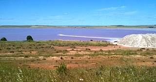
Lochiel is a small town in the Mid North of South Australia 125 km (78 mi) north of Adelaide. The town lies beside on the western edge of Lake Bumbunga and at the eastern foot of the Hummocks Range. The Augusta Highway, a section of Highway 1, runs on a strip between the township and the lake, which dwarfs the former.
Alford is a settlement in South Australia. Alford is in the Hundred of Tickera, northern Yorke Peninsula, about midway between the towns of Kadina and Port Broughton. The natural landform is undulating fertile plains, which often feature limestone and dunes. Founded on the agricultural industry, which surrounds the township, most of the original mallee scrub vegetation has been cleared for highly productive broad-acre wheat and barley farming, plus grazing and mixed farming.

The Barunga Range is a range of hills in the northern Mount Lofty Ranges starting near Clements Gap and Merriton in South Australia's Mid North. At the range's southern end it merges with Hummock Range at Barunga Gap, approximately 10 kilometres (6.2 mi) south west of Snowtown. The name 'Barunga' derives from an indigenous term meaning "gap in the range".
Ninnes is a locality at the northeastern corner of Yorke Peninsula and western side of the Mid North of South Australia. It lies where the Upper Yorke Road from Kulpara to Bute is crossed by the road from Paskeville to Lochiel. The dominant industry is broadacre grain and sheep farming.

The County of Daly is one of the 49 cadastral counties of South Australia. It was proclaimed in 1862 and named for Governor Dominick Daly. It covers the northern half of Yorke Peninsula stretching just east of the Hummock-Barunga Range in the west and just past the Broughton River in the north.
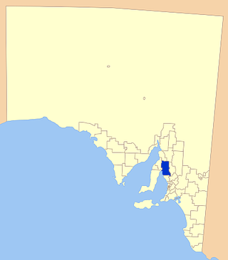
The Hundred of Cameron is a cadastral unit of hundred located in the Mid North of South Australia centred on Lake Bumbunga. The northern Hummock Range occupies much of the western half of the area and the Adelaide-Port Augusta railway line runs near and parallel to the eastern boundary. It is one of the 16 hundreds of the County of Daly. It was named in 1869 by Governor James Fergusson for early pioneer Hugh Cameron.
The District Council of Port Broughton was a local government area in South Australia from 1892 to 1997 seated at the town of Port Broughton.
The District Council of Bute was a local government area in South Australia from 1885 to 1997.

Barunga Gap is a locality in South Australia about 12 kilometres (7.5 mi) south west of Snowtown. Barunga Gap was named in reference to the co-located pass between the Barunga Range to the north and Hummock Range to the south. The word 'Barunga' derives from an indigenous term meaning "gap in the range". See Barunga Range § Etymology
The District Council of Snowtown was a local government area in South Australia from 1888 to 1987.
South Hummocks is a locality in the Mid North of South Australia at the head of Gulf St Vincent adjacent to Yorke Peninsula on the southeastern slopes of the Hummock Range.

The Hundred of Ninnes is a cadastral unit of hundred located in the Mid North of South Australia centred on the Ninnes Plain. It is one of the 16 hundreds of the County of Daly and was proclaimed by Governor Anthony Musgrave on the last day of 1874.

The Hundred of Kulpara is a cadastral unit of hundred located on the northern Yorke Peninsula in South Australia and centred on the township of Kulpara. It is one of the 16 hundreds of the County of Daly and was proclaimed by Governor Dominick Daly on 12 June 1862.

The Hundred of Wokurna is a cadastral unit of hundred located in the Mid North of South Australia west of the Barunga Range. It is one of the 16 hundreds of the County of Daly and was proclaimed by Governor Anthony Musgrave on the last day of 1874.

The Hundred of Yackamoorundie is a cadastral unit of hundred in the County of Stanley, South Australia.

The Hundred of Nuriootpa is a cadastral unit of hundred in the County of Light, South Australia split between in the eastern Adelaide Plains and western Barossa Valley. Named in 1847 for an indigenous term officially thought to mean "bartering place" and traditionally used as neutral ground for trading between various indigenous tribes, it is bounded on the south and east by the North Para River.

