
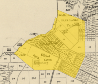
Wallaroo is a port town on the western side of Yorke Peninsula in South Australia, 160 kilometres (100 mi) northwest of Adelaide. It is one of the three Copper Triangle towns famed for their historic shared copper mining industry, and known together as "Little Cornwall", the other two being Kadina, about 8 kilometres (5 mi) to the east, and Moonta, about 18 kilometres (11 mi) south. In 2016, Wallaroo had a population of 3988 according to the census held..

Kadina is a town on the Yorke Peninsula of the Australian state of South Australia, approximately 144 kilometres north-northwest of the state capital of Adelaide. The largest town of the Peninsula, Kadina is one of the three Copper Triangle towns famous for their shared copper mining history. The three towns are known as "Little Cornwall" for the significant number of immigrants from Cornwall who worked at the mines in the late 19th century.

Moonta is a town on the Yorke Peninsula of South Australia, 165 km (103 mi) north-northwest of the state capital of Adelaide. It is one of three towns known as the Copper Coast or "Little Cornwall" for their shared copper mining history.

Paskeville is a town on South Australia's Yorke Peninsula. It is located approximately 20 km east of Kadina on the Copper Coast Highway towards Adelaide. At the 2016 census, Paskeville had a population of 178. The town's district is administratively divided between the Copper Coast Council and the District Council of Barunga West.

Bute is a town in the Mid North of South Australia, approximately 40 kilometres (25 mi) east of Wallaroo and 24 kilometres west of Snowtown. It was proclaimed as a town in 1884 and named after the Isle of Bute, in the Firth of Clyde, Scotland. It was the original site of the Yorke Peninsula Field Days in 1895; they are now held outside Paskeville.
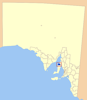
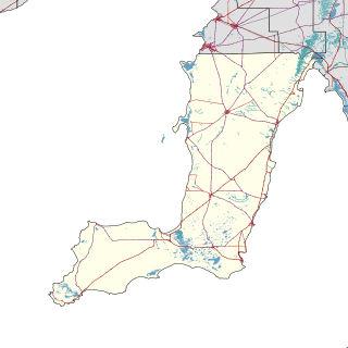
The Copper Coast Council is a local government area in the Australian state of South Australia located at the northern end of the Yorke Peninsula. It was established in 1997 and its seat is in Kadina.

Clinton is a locality in the Australian state of South Australia located on the east coast of Yorke Peninsula overlooking the north west head of Gulf St Vincent about 101 kilometres (63 mi) west of the state capital of Adelaide and about 36 kilometres (22 mi) north-east of the municipal seat of Maitland.

Alford is a settlement in South Australia. Alford is in the Hundred of Tickera, northern Yorke Peninsula, about midway between the towns of Kadina and Port Broughton. The natural landform is undulating fertile plains, which often feature limestone and dunes. Founded on the agricultural industry, which surrounds the township, most of the original mallee scrub vegetation has been cleared for highly productive broad-acre wheat and barley farming, plus grazing and mixed farming.

Wallaroo Mines is a suburb of the inland town of Kadina on the Yorke Peninsula in the Copper Coast Council area. It was named for the land division in which it was established in 1860, the Hundred of Wallaroo, as was the nearby coastal town of Wallaroo. The boundaries were formally gazetted in January 1999 for "the long established name".
Jericho is a suburb of the town of Kadina on the Yorke Peninsula. It is located in the Copper Coast Council. The boundaries were formally gazetted in January 1999, although the name had long been in use for the area. It was surveyed in 1871 as one of four "occupation blocks" to meet high demand for housing near Wallaroo Mines.
Winulta was a town in the Australian state of South Australia on northern Yorke Peninsula around 10 km from Clinton on the Clinton-Maitland road. It was first settled for farming around 1876. The earliest farmers were William Short, Thomas Kenny and John Sharrad.
Ninnes is a locality at the northeastern corner of Yorke Peninsula and western side of the Mid North of South Australia. It lies where the Upper Yorke Road from Kulpara to Bute is crossed by the road from Paskeville to Lochiel. The dominant industry is broadacre grain and sheep farming.
Wallaroo Plain is a locality in the Australian state of South Australia located on the west coast of Yorke Peninsula immediately adjoining Spencer Gulf about 148 kilometres north-west of the state capital of Adelaide.
New Town is a suburb of the town of Kadina on the Yorke Peninsula. It is located in the Copper Coast Council. The boundaries were formally gazetted in January 1999, although the name had long been in use for the area.

The County of Daly is one of the 49 cadastral counties of South Australia. It was proclaimed in 1862 and named for Governor Dominick Daly. It covers the northern half of Yorke Peninsula stretching just east of the Hummock-Barunga Range in the west and just past the Broughton River in the north.
The District Council of Bute was a local government area in South Australia from 1885 to 1997.
The District Council of Kadina was a local government area in South Australia from 1888 to 1984.
The District Council of Green's Plains was a local government area in South Australia from 1871 to 1888. It was the first local government on the Yorke Peninsula.
The Hundred of Wallaroo is a cadastral unit of hundred located on the Copper Coast of South Australia. It is one of the 16 hundreds of the County of Daly. It was named in 1862 by Governor Dominick Daly after the indigenous term wadla warru presumed to mean wallaby urine.

The Hundred of Kulpara is a cadastral unit of hundred located on the northern Yorke Peninsula in South Australia and centred on the township of Kulpara. It is one of the 16 hundreds of the County of Daly and was proclaimed by Governor Dominick Daly on 12 June 1862.

