
The Barunga West Council is a local government area in the Yorke and Mid North region of South Australia. The council seat is at Port Broughton, with a sub-office at Bute.

The Yorke Peninsula Council is a local government area in South Australia. Its boundaries include most of the Yorke Peninsula. The council seat is at Maitland; the council also maintains branch offices at Minlaton and Yorketown.
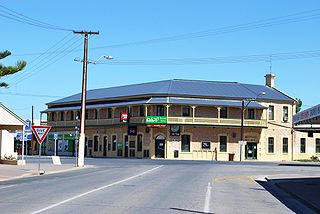
Yorketown is a town and a locality in the Australian state of South Australia located in the southern Yorke Peninsula about 91 kilometres (57 mi) west of the state capital of Adelaide and about 70 kilometres (43 mi) south of the municipal seat of Maitland. At the 2016 census, the locality had a population of 969 of which 642 lived in its town centre.

Bute is a town in the Northern Yorke peninsula of South Australia, approximately 40 kilometres (25 mi) east of Wallaroo and 24 kilometres west of Snowtown. It was proclaimed as a town in 1884 and named after the Isle of Bute, in the Firth of Clyde, Scotland. It was the original site of the Yorke Peninsula Field Days in 1895; they are now held outside Paskeville.
Balgowan is a small coastal town on the west coast of South Australia's Yorke Peninsula. It is located approximately 20 kilometres west of Maitland. Like other towns on popular with tourists on Yorke Peninsula, it has a large number of shacks, holiday houses, caravan facilities and a boat ramp. The population generally increases during peak holiday periods.

Clinton is a locality in the Australian state of South Australia located on the east coast of Yorke Peninsula overlooking the north west head of Gulf St Vincent about 101 kilometres (63 mi) west of the state capital of Adelaide and about 36 kilometres (22 mi) north-east of the municipal seat of Maitland.
Kainton is a small town in the Australian state of South Australia situated about 10 km south of Paskeville in the upper Yorke Peninsula.
Winulta was a town in the Australian state of South Australia on northern Yorke Peninsula around 10 km from Clinton on the Clinton-Maitland road. It was first settled for farming around 1876. The earliest farmers were William Short, Thomas Kenny and John Sharrad.

The County of Daly is one of the 49 cadastral counties of South Australia. It was proclaimed in 1862 and named for Governor Dominick Daly. It covers the northern half of Yorke Peninsula stretching just east of the Hummock-Barunga Range in the west and just past the Broughton River in the north.
Nalyappa is a locality in the Australian state of South Australia located on the west coast of Yorke Peninsula immediately adjoining Spencer Gulf about 128 kilometres north-west of the state capital of Adelaide.
The District Council of Northern Yorke Peninsula was a local government area in South Australia from 1984 to 1997. The council seat was at Kadina.
The District Council of Central Yorke Peninsula was a local government area in South Australia from 1969 to 1997. The council seat was at Maitland.

County of Fergusson is a cadastral unit located in the Australian state of South Australia which spans Yorke Peninsula south of Price. It was proclaimed in 1869 by Governor Fergusson after whom the county was named.
The District Council of Green's Plains was a local government area in South Australia from 1871 to 1888. It was the first local government on the Yorke Peninsula.
Clinton Centre is a locality in the Australian state of South Australia located on the northern end of Yorke Peninsula about 99 kilometres north-west of the state capital of Adelaide and about 27 kilometres north-east of the municipal seat in Maitland.
The District Council of Yorke Peninsula was a local government area on the Yorke Peninsula of South Australia from 1888 to 1969.
The District Council of Minlaton was a local government area in South Australia from 1888 to 1997 seated at Minlaton on the Yorke Peninsula.

The Hundred of Kadina is a cadastral unit of hundred located on the north-western Yorke Peninsula in South Australia. It is one of the 16 hundreds of the County of Daly and was proclaimed by Governor Dominick Daly on 12 June 1862.

The Hundred of Kulpara is a cadastral unit of hundred located on the northern Yorke Peninsula in South Australia and centred on the township of Kulpara. It is one of the 16 hundreds of the County of Daly and was proclaimed by Governor Dominick Daly on 12 June 1862.
Clinton, South Australia is a town and a locality in South Australia.

