
The Mid Murray Council is a local government area in South Australia in the Murray and Mallee region of South Australia. The council spans the area from the Riverland through the Murraylands to the eastern slopes of the Mount Lofty Ranges. It includes 220 km of the Murray River. The council seat is at Mannum; it also maintains secondary offices at Cambrai and Morgan.

The District Council of Lower Eyre Peninsula is a local government area located on Eyre Peninsula in South Australia. The district covers the southern tip of the peninsula, except for the small area taken up by the City of Port Lincoln.
Perlubie is a locality in the Australian state of South Australia located on the west coast of Eyre Peninsula about 472 kilometres (293 mi) north-west of the state capital of Adelaide and about 24 kilometres (15 mi) north-east of the municipal seat of Streaky Bay.
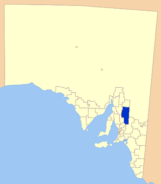
The Regional Council of Goyder is a local government area located in the Mid North region of South Australia. The council area is reliant on agriculture as a mainstay of its economy, with manufacturing and tourism also becoming prominent. The council seat is at Burra. A branch office is at Eudunda.
Dutton is a settlement in South Australia. The small township lies approximately six kilometres (3.7 mi) north of Truro on the Eudunda Road. It was first laid out in 1866 and lots were advertised for sale in the German-language newspaper Südaustralische Zeitung.

Bower is a town in South Australia, approximately halfway between Eudunda and Morgan on the Thiele Highway.

Hansborough is a locality along the former Morgan railway line adjacent to the Thiele Highway, in South Australia's Mid North region. It is situated 9 kilometres south-west of Eudunda and 18 kilometres north-east of Kapunda. The Light River runs through the locality.

Bundey is a locality in the Mid North region of South Australia. It is located on Goyder's Line, on the plains between Burra and Morgan in the Regional Council of Goyder. The bounded locality of Bundey corresponds to the boundaries of the cadastral Hundred of Bundey, except for the southwestern corner of the Hundred which is the northeastern corner of the locality of Geranium Plains. Bundey was named in 1878 for politician William Henry Bundey.

Geranium Plains is a small town in the Regional Council of Goyder in South Australia. The post office opened in 1894, but has since closed. There was a proposal to rename it to Iperta in 1916, but this did not go ahead.

Mount Dutton Bay is a coastal locality in the Eyre and Western region of South Australia, situated in the District Council of Lower Eyre Peninsula. The name and boundaries were formalised in October 2003 in respect of the long established local name which is derived from the body of water known as Mount Dutton Bay. The locality incorporates three older residential "shack sites": Mount Dutton Bay West, on Dolphin Drive, Mount Dutton Bay East, on Woolshed Drive, and Shelley Beach/Salt Creek, on Shelly Beach Road. It is part of the cadastral Hundred of Lake Wangary.

The Hundred of Bagot is a cadastral hundred in the County of Eyre in South Australia. It is located between the Mount Lofty Ranges on the west and the Murray River further to the east. The Hundred of Bagot is almost exactly spans the boundaries of the contemporary town of Sedan.

Mount Mary is a small town on the Thiele Highway between Eudunda and Morgan in South Australia. It was also served by the Morgan railway line from 1878 until 1969 and is named for the Mount Mary railway station on that line.

NNeales Flat is a rural locality southeast of Eudunda in the Mid North region in South Australia. It is in the Regional Council of Goyder local government area, the South Australian House of Assembly electoral district of Stuart and the Australian House of Representatives Division of Grey.
Brownlow is a locality in the Australian state of South Australia about 98 kilometres north-east of the Adelaide city centre
Ngapala is a rural locality in the Mid North region of South Australia, situated in the Regional Council of Goyder. It was established in August 2000, when boundaries were formalised for the "long established local name". It is divided between the cadastral Hundreds of English and Julia Creek.

The District Council of Morgan was a local government area in South Australia from 1888 to 1997, centring on the town of Morgan.
The County of Bosanquet is a cadastral unit in the Australian state of South Australia that covers land both in the north of the Eyre Peninsula and to the peninsula's north. It was proclaimed on 23 October 1913 and was named after Sir Day Hort Bosanquet, the Governor of South Australia from 1909 to 1914.
The Hundred of English is a cadastral unit of hundred containing all or part of the localities of Brady Creek, Robertstown, Rocky Plain, Geranium Plains, Ngapala, Point Pass, Australia Plains and Eudunda. It is one of the 16 hundreds of the County of Eyre. It was named in 1866 by Governor of South Australia, Dominick Daly after T English MLC (1820–1884), a former mayor of Adelaide and current Member of the colony's Legislative Council at the time.
The Hundred of Anna is a cadastral unit of hundred in South Australia. It contains all or most of the localities of Steinfeld, Annadale and Sandleton as well as small parts of the localities of Dutton East, Truro and Sedan. It is one of the 16 hundreds of the County of Eyre.
The Hundred of the Murray was a cadastral hundred in South Australia spanning land two miles either side of the navigable portion of the Murray River in the 1850s and 1860s.

