
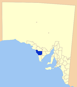
The Hundred of Skurray is a hundred within the County of Eyre, South Australia. [1]
The main town of the hundred is Blanchetown.
The Hundred of Skurray is a hundred within the County of Eyre, South Australia. [1]
The main town of the hundred is Blanchetown.
The traditional owners are the Ngarrindjeri people.
Since the 1850s, European settlement has spread from Blanchetown.

Sturt Highway is an Australian national highway in New South Wales, Victoria, and South Australia. It is an important road link for the transport of passengers and freight between Sydney and Adelaide and the regions situated adjacent to the route.

The District Council of Lower Eyre Peninsula is a local government area located on Eyre Peninsula in South Australia. The district covers the southern tip of the peninsula, except for the small area taken up by the City of Port Lincoln.

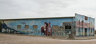
Blanchetown is a small township in South Australia, on the (west) bank of the Murray River, 130 kilometres (81 mi) northeast of Adelaide. The Blanchetown Bridge is the westernmost of the four crossings of the Sturt Highway over the Murray River. During the nineteenth century it was an important transportation centre on the lower Murray. In the early 21st century, Blanchetown has been described as "a strange mixture of historic buildings and temporary shacks built by holidaymakers on the banks of the river". Blanchetown is widely regarded as the entrance to the Riverland district.

Wudinna District Council is a rural local government area on central Eyre Peninsula, South Australia. Its seat is Wudinna, on the Eyre Highway, 580 kilometres (360 mi) west of Adelaide. The district's economy is largely driven by agriculture, mainly cereal crops, with beef and sheep commonly farmed as well.
The District Council of Elliston is a local government area covering around 6500 km2 on the Western Eyre Peninsula in South Australia. Established in 1888, the district has a diverse economy, with agriculture, commercial fishing and tourism making up the majority of the local economy.

The County of Flinders is one of the 49 cadastral counties of South Australia. The county covers the southern part of the Eyre Peninsula “bounded on the north by a line connecting Point Drummond with Cape Burr, and on all other sides by the seacoast, including all islands adjacent to the main land.”
Water Witch was a single-masted vessel rigged as a cutter built during 1835 in Van Diemen's Land and sunk in 1842 whilst moored in the River Murray at Moorundie, south of Blanchetown in South Australia (SA). Her wreck site was discovered in 1982 and received statutory protection as a historic shipwreck in 1983. The wreck site was the subject of an underwater survey in March 1984. She was the first European vessel to enter the River Murray via its mouth, her role in the charting of the lower reaches of the River Murray including Lake Alexandrina whilst under the command of William Pullen and her association with Edward John Eyre.

Paisley is a locality in the Murray Mallee region of South Australia, across the Murray River from Blanchetown, South Australia. It was formally named in September 2000 for the Hundred of Paisley which contains it. The Hundred of Paisley was named by Governor MacDonnell in 1861 for his private secretary, J. G. Paisley.

The County of Eyre is one of the 49 cadastral counties of South Australia. It was proclaimed by Governor George Grey in 1842 and named for the explorer Edward John Eyre. It covers a portion of the state between the Adelaide Hills in the west and the Murray River in the east from Robertstown and Mannum on the northern boundary to Sedan and Swan Reach on the southern boundary.
The County of Musgrave is a cadastral unit in the Australian state of South Australia that covers land on the west coast of Eyre Peninsula. It was proclaimed on 22 June 1876 and named after Anthony Musgrave, the Governor of South Australia from 9 June 1876 to 29 January 1877.
The District Council of Truro was a local government area in South Australia from 1876 to 1991.
County of Hore-Ruthven is a cadastral unit in the Australian state of South Australia that covers land both in the north of the Eyre Peninsula and to the peninsula's north. It was proclaimed in 1933 and was named after Alexander Hore-Ruthven, the Governor of South Australia from 1928 to 1934.
The County of Bosanquet is a cadastral unit in the Australian state of South Australia that covers land both in the north of the Eyre Peninsula and to the peninsula's north. It was proclaimed on 23 October 1913 and was named after Sir Day Hort Bosanquet, the Governor of South Australia from 1909 to 1914.
County of Manchester is a cadastral unit located in the Australian state of South Australia that covers land both located in the north-east of Eyre Peninsula and to the peninsula's north. It was proclaimed in 1891 and named after George Montagu, 6th Duke of Manchester who was the father-in-law of the Earl of Kintore GCMG, the Governor of South Australia at the time.

County of Le Hunte is a cadastral unit located in the Australian state of South Australia that covers land located in the centre of Eyre Peninsula. It was proclaimed in 1908 and named after George Le Hunte who was the Governor of South Australia from July 1903 to February 1909.

County of Buxton is a cadastral unit located in the Australian state of South Australia that covers land located in the centre of Eyre Peninsula. It was proclaimed in 1896 and named after Thomas Buxton who was the Governor of South Australia from 29 October 1895 to 29 March 1899. It has been divided into thirteen sub-divisions known as hundreds, with the most recent being created in 1928.
Roonka Conservation Park is a protected area in the Australian state of South Australia located in the gazetted locality of Blanchetown about 5.8 kilometres (3.6 mi) north of the Blanchetown town centre.
The Ngaiawang (Ngayawang) were an Aboriginal Australian people of the western Riverland area of South Australia, with a language considered part of the Lower Murray group. They are now considered extinct. They have sometimes been referred to as part of the Meru people, a larger grouping which could also include the Ngawait and Erawirung peoples. They were called Birta by the Kaurna and Ngadjuri peoples, variations of Murundi by the Jarildekald people, and were also known various other terms and spellings.
Annadale is a locality in South Australia. It is located on the plains east of the Mount Lofty Ranges astride the Sturt Highway 110 kilometres (68 mi) from Adelaide, between Truro and Blanchetown, South Australia. Halfway House Road is a heavy vehicle detour route that runs south from the Sturt Highway at Annadale. Annadale occupies the central part of the hundred of Anna.
The District Council of Swan Reach was a local government area in the Murraylands of South Australia from 1888 to 1933.
| | This South Australia geography article is a stub. You can help Wikipedia by expanding it. |