The lands administrative divisions of South Australia are the cadastral units of counties and hundreds in South Australia. They are located only in the south-eastern part of the state, and do not cover the whole state. 49 counties have been proclaimed across the southern and southeastern areas of the state historically considered to be arable and thus in need of a cadastre. Within that area, a total of 540 hundreds have been proclaimed, although five were annulled in 1870, and, in some cases, the names reused elsewhere.

The Kaiserstuhl Conservation Park is a protected area located in the Australian state of South Australia in the suburb of Flaxman Valley about 80 kilometres (50 mi) north-east of the state capital of Adelaide and about 12 kilometres (7.5 mi) south-east of the town of Tanunda.

Keyneton is a locality in South Australia. The town is in the Mid Murray Council local government area, 82 kilometres (51 mi) north-east of the state capital, Adelaide. At the 2011 census, Keyneton and the surrounding area had a population of 534.

The County of Flinders is one of the 49 cadastral counties of South Australia. The county covers the southern part of the Eyre Peninsula “bounded on the north by a line connecting Point Drummond with Cape Burr, and on all other sides by the seacoast, including all islands adjacent to the main land.”

The Hundred of Belvidere is a cadastral unit of hundred located in the north Barossa Valley of South Australia in the County of Light.

Andrews is a rural locality in the Northern Areas Council of South Australia, located on the Hill River. Its boundaries were formalised in April 2001 for the long established name for the area. The district, which is primarily dedicated to primary production, mainly grain farming, is in the Spalding Ward of the council. The township has bulk grain handling and storage facilities as well as limited sporting and community facilities. The Hill River Road and the Hill River run north–south through the locality, while Andrews Road runs east–west, connecting the Goyder Highway with RM Williams Way. In the 2011 census, the population of Andrews was too low to separately report; it was included in that of adjacent Spalding.

The Hundred of Port Gawler is a cadastral unit of hundred located on the central Adelaide Plains in South Australia and bounded on the south by the Gawler River. It is centred on the town of Two Wells with the locality of Port Gawler at the south western corner of its boundary. It is one of the eight hundreds of the County of Gawler. It was named in 1851 by Governor Henry Young either directly or indirectly after the former Governor George Gawler.

The County of Hindmarsh is one of the 49 cadastral counties of South Australia. It was proclaimed by Governor George Grey in 1842 and named for Governor John Hindmarsh.

The Hundred of Bagot is a cadastral hundred in the County of Eyre in South Australia. It is located between the Mount Lofty Ranges on the west and the Murray River further to the east. The Hundred of Bagot is almost exactly spans the boundaries of the contemporary town of Sedan.

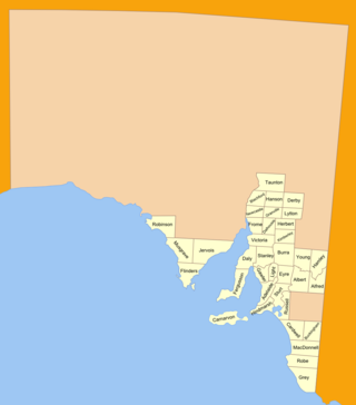
The County of Eyre is one of the 49 cadastral counties of South Australia. It was proclaimed by Governor George Grey in 1842 and named for the explorer Edward John Eyre. It covers a portion of the state between the Adelaide Hills in the west and the Murray River in the east from Robertstown and Mannum on the northern boundary to Sedan and Swan Reach on the southern boundary.

County of Burra is a cadastral unit located in the Australian state of South Australia which covers land located in the state’s east associated with the town of Burra. It was proclaimed in 1851 by Governor Young and named after the town of Burra.

Walloway is a locality in the Australian state of South Australia located about 255 kilometres (158 mi) north of the state capital of Adelaide and about 10 kilometres (6.2 mi) north of the municipal seat of Orroroo.
The District Council of Ridley was a local government area in South Australia from 1976 to 1991.
The Hundred of Beatty, formerly the Hundred of Krichauff is a cadastral unit of hundred located in the Murraylands of South Australia spanning the localities of Beatty and Mount Mary.
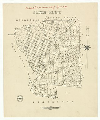
The Hundred of Jutland is a hundred of the County of Sturt in South Australia. It is located on the east Mount Lofty Ranges foothills. The Hundred of South Rhine was proclaimed in 1851 but the name was changed in 1918 to the current, after the Battle of Jutland which took place off the coast of Denmark in 1916. The name change was part of a process to remove "names of enemy origin" at the time of World War I.

The County of Albert is one of the 49 cadastral counties of South Australia on the east banks of the River Murray. It was proclaimed by Governor Richard MacDonnell in 1860 and named for Albert, Prince Consort of Queen Victoria.

County of Blachford is a cadastral unit located in the Australian state of South Australia that covers land between the east coast of Lake Torrens and the western side of the Flinders Ranges about 90 kilometres (56 mi) north-east of the city of Port Augusta. It was proclaimed in 1877 and named after Frederic Rogers, 1st Baron Blachford who was the Under Secretary of State for the Colonies from 1860 to 1871. It has been partially divided in the following sub-units of hundreds – Barndioota, Cotabena, Warrakimbo, Wonoka and Woolyana.

County of Hanson is a cadastral unit located in the Australian state of South Australia that covers land in the Flinders Ranges immediately east of the town of Hawker. It was proclaimed on 20 July 1877 and is named after Sir Richard Davies Hanson who served as Premier, Administrator and Chief Justice of South Australia. It has been partially divided in the following sub-units of hundreds – Adams, Arkaba, French, Moralana and Warcowie.
The District Council of Sedan was a local government area in South Australia seated at the town of Sedan from 1933 until 1976.
Marne Valley Conservation Park is a protected area in the Australian state of South Australia located in the locality of Cambrai about 77 kilometres (48 mi) north-west of the state capital of Adelaide and about 30 kilometres (19 mi) west of the municipal seat of Mannum.
