
The Mid Murray Council is a local government area in South Australia in the Murray and Mallee region of South Australia. The council spans the area from the Riverland through the Murraylands to the eastern slopes of the Mount Lofty Ranges. It includes 220 km of the Murray River. The council seat is at Mannum; it also maintains secondary offices at Cambrai and Morgan.

Sedan is a rural town in South Australia. It is located about 100 kilometres east of Adelaide and about 20 kilometres west of the Murray River. It is located on the dry eastern side of the Mount Lofty Ranges.

Keyneton is a locality in South Australia. The town is in the Mid Murray Council local government area, 82 kilometres (51 mi) north-east of the state capital, Adelaide. At the 2011 census, Keyneton and the surrounding area had a population of 534.

The Hundred of Belvidere is a cadastral unit of hundred located in the north Barossa Valley of South Australia in the County of Light.

The Hundred of Monarto is a cadastral unit of hundred, the centre of which lies about 47 kilometres (29 mi) east southeast of Adelaide in South Australia and about 19 kilometres (12 mi) west of the Murray River. One of the ten hundreds of the County of Sturt, it is bounded on the west by the Bremer River, with the north west corner being set at the point where Mount Barker Creek merges with the river. It was named in 1847 by Governor Frederick Robe after "Queen Monarto", an aboriginal woman who lived at the time in the area. According to John Wrathall Bull, in his writings on early South Australia history, she was the lubra (partner) of aboriginal tribal leader "King John", whose tribe resided "on the banks of the Murray" at the time.

The County of Eyre is one of the 49 cadastral counties of South Australia. It was proclaimed by Governor George Grey in 1842 and named for the explorer Edward John Eyre. It covers a portion of the state between the Adelaide Hills in the west and the Murray River in the east from Robertstown and Mannum on the northern boundary to Sedan and Swan Reach on the southern boundary.
The District Council of Ridley-Truro was a local government area in South Australia from 1991 to 1997.
The District Council of Mannum was a local government area in South Australia from 1877 to 1997, centring on the town of Mannum.

The District Council of Morgan was a local government area in South Australia from 1888 to 1997, centring on the town of Morgan.
The District Council of Ridley was a local government area in South Australia from 1976 to 1991.
The District Council of Truro was a local government area in South Australia from 1876 to 1991.
The Hundred of Jellicoe is a cadastral hundred in the County of Eyre in South Australia. It is located on the east Mount Lofty Ranges foothills. The Hundred of North Rhine was proclaimed in 1851 but the name was changed in 1918 to the current, after Admiral John Jellicoe, as part of a process to remove "names of enemy origin" at the time of World War I.
The Hundred of Beatty, formerly the Hundred of Krichauff is a cadastral unit of hundred located in the Murraylands of South Australia spanning the localities of Beatty and Mount Mary.
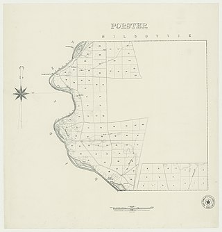
The Hundred of Forster, formerly the hundreds of Giles and Morphett, is a cadastral hundred in the County of Albert, South Australia.
Fisher is a locality in the Australian state of South Australia located about 96 kilometres (60 mi) north-east of the state capital of Adelaide and about 47 kilometres (29 mi) north-east of the municipal seat in Mannum.
The District Council of Swan Reach was a local government area in the Murraylands of South Australia from 1888 to 1933.

The County of Frome is one of the 49 cadastral counties of South Australia in straddling the Mid North and Flinders Ranges regions. It was proclaimed in 1851 by Governor Henry Young and was named for the former Surveyor-General of South Australia, Edward Charles Frome. The iconic Mount Remarkable in the Hundred of Gregory is at the centre of the county.

The County of Albert is one of the 49 cadastral counties of South Australia on the east banks of the River Murray. It was proclaimed by Governor Richard MacDonnell in 1860 and named for Albert, Prince Consort of Queen Victoria.

The Hundred of Kapunda is a cadastral unit of hundred in the County of Light, South Australia in the lower Mid North just north of the Barossa Valley. Named for the Kapunda copper mine in the 1850s which in turn is thought to have been a corruption of the indigenous word cappieoonda, referring to the spring which supplied water to the town. The hundred is bounded on the south by the River Light
The District Council of Sedan was a local government area in South Australia seated at the town of Sedan from 1933 until 1976.

