
The Hundred of Ridley is a cadastral hundred in the County of Russell in South Australia. It was proclaimed on 19 April 1860 and included a portion of the former Hundred of the Murray. [1]
The Hundred of Ridley is a cadastral hundred in the County of Russell in South Australia. It was proclaimed on 19 April 1860 and included a portion of the former Hundred of the Murray. [1]
The Division of Angas was an Australian Electoral Division in South Australia. The division was created in 1949 and abolished in 1977. It was named for George Fife Angas, a South Australian pioneer.
Oran Park is a suburb of south-west Sydney, within the Macarthur Region, in the state of New South Wales, Australia in Camden Council.
Tungkillo is a town in South Australia, located approximately 5 km (3.1 mi) south of Mount Pleasant. It sits on Adelaide-Mannum Road, 60 km (37 mi) north-east of the state capital, Adelaide and 25 km (16 mi) north-west of Mannum. At the 2006 census, Tungkillo had a population of 360.

Ferryden Park is a north-western suburb of Adelaide 6.3 km from the central business district, in the state of South Australia, Australia. Situated in the City of Port Adelaide Enfield local government area, it is adjacent to Kilkenny, Angle Park, Woodville Gardens, Croydon Park, and Regency Park. It is bounded to the north by Murray Street, west by Liberty Grove and Hassell Street, south by Regency Road and to the east by Days Road.
Yatala Vale is an outer northeastern rural suburb of Adelaide, South Australia. It is located in the City of Tea Tree Gully local government area, and is adjacent to Golden Grove and Fairview Park, as well as the rural districts of Upper Hermitage and Gould Creek.

Murray County was one of the original Nineteen Counties in New South Wales and is now one of the 141 Lands administrative divisions of New South Wales. It included the area which is now part of Canberra and as far north as Lake George and Yass. It was originally bounded on the west by the Murrumbidgee River, on the east by the Shoalhaven River and on the north by the Yass River. A large area of the county was transferred to the Commonwealth government in 1909 in the Seat of Government Acceptance Act to make part of the Australian Capital Territory, along with land in Cowley County. Since then, the ACT border is now part of the western boundary. Part of the ACT border is determined by property boundaries in the Parish of Keewong, in the County of Murray; specifically the southern end of portions 177, 218, 211, 36, and 38. This is mentioned in the Seat of Government Acceptance Act of 1909.

The County of Sturt is one of the 49 cadastral counties of South Australia. It was proclaimed by Governor George Grey in 1842 and named for early Australian explorer, Charles Sturt. It stretches from the Bremer River and eastern slopes of the Adelaide Hills at Nairne and Tungkillo to the Murray River in the east and in the south, the portion of Lake Alexandrina north of a line from Point Sturt to Pomanda Island. This includes the west-of-river parts of the contemporary local government areas of the Mid Murray Council and Murray Bridge City.
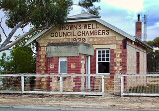
The District Council of Brown's Well was a local government area in South Australia from 1916 to 1997. The name stemmed from the Brown's Well pastoral station, which was located near the council seat of Paruna. Meetings were also held on a regular basis in the institute at Alawoona, which was the district's major centre.
Murray Bridge East is a semi-rural satellite locality of Murray Bridge in South Australia east of the Murray River and the eponymous bridge. Its boundaries were formalised in March 2000 to cover a portion of land immediately across the river to the east of the main Murray Bridge conurbation. It is bounded on the southwest by the Adelaide-Melbourne railway line and the defunct Rabila Railway Station is thus on the locality's southern boundary. The Karoonda Highway motor traffic route commences at Murray Bridge East and heads northeast through Karoonda to Loxton.

County of Fergusson is a cadastral unit located in the Australian state of South Australia which spans Yorke Peninsula south of Price. It was proclaimed in 1869 by Governor Fergusson after whom the county was named.

County of Young is a cadastral unit located in the Australian state of South Australia covers land located in the state’s east on the north side of the Murray River. It was proclaimed in 1860 by Governor MacDonnell and named after his predecessor, Governor Young. It has been partially divided in the following sub-units of hundreds – Markaranka, Parcoola, Pooginook and Stuart.
The District Council of Ridley-Truro was a local government area in South Australia from 1991 to 1997.
The District Council of Mannum was a local government area in South Australia from 1877 to 1997, centring on the town of Mannum.
The District Council of Ridley was a local government area in South Australia from 1976 to 1991.
The District Council of Truro was a local government area in South Australia from 1876 to 1991.
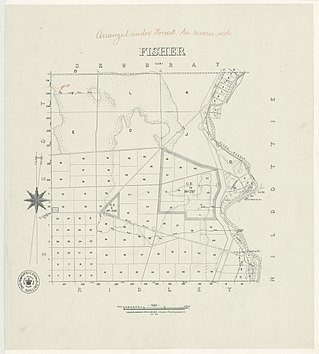
The Hundred of Fisher is a cadastral hundred of South Australia, founded in 1860. It is located at 34°36′16″S 139°36′6″E in the County of Eyre, South Australia. The main town of the hundred is Punyelroo, in the Mid Murray Council.

The County of Albert is one of the 49 cadastral counties of South Australia on the east banks of the River Murray. It was proclaimed by Governor Richard MacDonnell in 1860 and named for Albert, Prince Consort of Queen Victoria.
Burra Creek is a stream in South Australia rising in the northern Mount Lofty Ranges, flowing generally southwards and eastwards to join the River Murray at Morgan.

County of Hanson is a cadastral unit located in the Australian state of South Australia that covers land in the Flinders Ranges immediately east of the town of Hawker. It was proclaimed on 20 July 1877 and is named after Sir Richard Davies Hanson who served as Premier, Administrator and Chief Justice of South Australia. It has been partially divided in the following sub-units of hundreds – Adams, Arkaba, French, Moralana and Warcowie.
The District Council of Caurnamont was a local government area in South Australia seated at Walkers Flat on the right bank of the Murray River from 1885 until 1935.
Other Details: Area 175 square miles. Formerly portion of the original Hundred of Murray.
34°44′35″S139°29′28″E / 34.743°S 139.491°E Coordinates: 34°44′35″S139°29′28″E / 34.743°S 139.491°E
| | This South Australia geography article is a stub. You can help Wikipedia by expanding it. |