
The Hundred of Hay is a hundred within the County of Eyre, South Australia. [1] The main town of the hundred is McBean Pound.
The Hundred of Hay is a hundred within the County of Eyre, South Australia. [1] The main town of the hundred is McBean Pound.

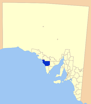
The District Council of Lower Eyre Peninsula is a local government area located on Eyre Peninsula in South Australia. The district covers the southern tip of the peninsula, except for the small area taken up by the City of Port Lincoln.
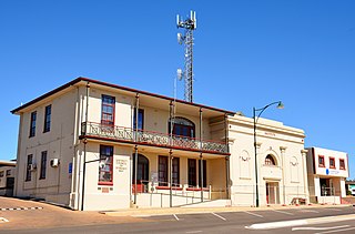
The District Council of Streaky Bay is a local government area in South Australia located on the Eyre Peninsula. Streaky Bay is the main population centre of about 1,200 people serving an agricultural district based on farming wheat and other cereal crops, sheep, supplemented by fishing and tourism industries. The district covers an area of 6,251.1 square kilometres with a population of 2,074 people in 2016, according to the Australian Bureau of Statistics. Mayor of Streaky Bay is Travis Barber.

Wudinna District Council is a rural local government area on central Eyre Peninsula, South Australia. Its seat is Wudinna, on the Eyre Highway, 580 kilometres (360 mi) west of Adelaide. The district's economy is largely driven by agriculture, mainly cereal crops, with beef and sheep commonly farmed as well.
The District Council of Elliston is a local government area covering around 6500 km2 on the Western Eyre Peninsula in South Australia. Established in 1888, the district has a diverse economy, with agriculture, commercial fishing and tourism making up the majority of the local economy.

The County of Flinders is one of the 49 cadastral counties of South Australia. The county covers the southern part of the Eyre Peninsula “bounded on the north by a line connecting Point Drummond with Cape Burr, and on all other sides by the seacoast, including all islands adjacent to the main land.”

The County of Robinson is one of the 49 counties of South Australia. It was proclaimed in 1883 by Governor William Robinson who named it after himself. It lies on the north west coast of Eyre Peninsula stretching from Streaky Bay inland to include the Gawler Ranges Conservation Park at the southern cusp of the Gawler Ranges.
Pinkawillinie is a locality in the north of Eyre Peninsula in South Australia. It is a rural grain and grazing area in marginal country near Goyder's Line within the District Council of Kimba. It draws its name from the cadastral Hundred bearing the same name which is mostly included in the modern bounded locality, however the locality includes several other Hundreds and the Pinkawillinie Conservation Park, all within the Kimba region.

The County of Eyre is one of the 49 cadastral counties of South Australia. It was proclaimed by Governor George Grey in 1842 and named for the explorer Edward John Eyre. It covers a portion of the state between the Adelaide Hills in the west and the Murray River in the east from Robertstown and Mannum on the northern boundary to Sedan and Swan Reach on the southern boundary.

The County of York is one of the 49 cadastral counties of South Australia. It was proclaimed by acting Governor Samuel Way in 1895 and named for King George V who was known at the time as the Duke of York. It covers a portion of the state on the Eyre Peninsula east coast at the latitude of Whyalla. It stretches westwards to the eastern boundary of Lake Gilles Conservation Park
The County of Musgrave is a cadastral unit in the Australian state of South Australia that covers land on the west coast of Eyre Peninsula. It was proclaimed on 22 June 1876 and named after Anthony Musgrave, the Governor of South Australia from 9 June 1876 to 29 January 1877.
County of Hore-Ruthven is a cadastral unit in the Australian state of South Australia that covers land both in the north of the Eyre Peninsula and to the peninsula's north. It was proclaimed in 1933 and was named after Alexander Hore-Ruthven, the Governor of South Australia from 1928 to 1934.
The County of Bosanquet is a cadastral unit in the Australian state of South Australia that covers land both in the north of the Eyre Peninsula and to the peninsula's north. It was proclaimed on 23 October 1913 and was named after Sir Day Hort Bosanquet, the Governor of South Australia from 1909 to 1914.
County of Manchester is a cadastral unit located in the Australian state of South Australia that covers land both located in the north-east of Eyre Peninsula and to the peninsula's north. It was proclaimed in 1891 and named after George Montagu, 6th Duke of Manchester who was the father-in-law of the Earl of Kintore GCMG, the Governor of South Australia at the time.
Kulliparu Conservation Park is a protected area in the Australian state of South Australia located on the Eyre Peninsula in the gazetted localities of Colley, Karcultaby, Mount Cooper and Mount Damper about 59 kilometres (37 mi) west of the town centre in Kyancutta.

County of Le Hunte is a cadastral unit located in the Australian state of South Australia that covers land located in the centre of Eyre Peninsula. It was proclaimed in 1908 and named after George Le Hunte who was the Governor of South Australia from July 1903 to February 1909.

County of Buxton is a cadastral unit located in the Australian state of South Australia that covers land located in the centre of Eyre Peninsula. It was proclaimed in 1896 and named after Thomas Buxton who was the Governor of South Australia from 29 October 1895 to 29 March 1899. It has been divided into thirteen sub-divisions known as hundreds, with the most recent being created in 1928.
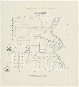
The Hundred of Fisher is a cadastral hundred of South Australia, founded in 1860. It is located at 34°36′16″S 139°36′6″E in the County of Eyre, South Australia. The main town of the hundred is Punyelroo, in the Mid Murray Council.
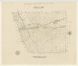
The Hundred of Neales is a hundred and a locality within the County of Eyre, South Australia
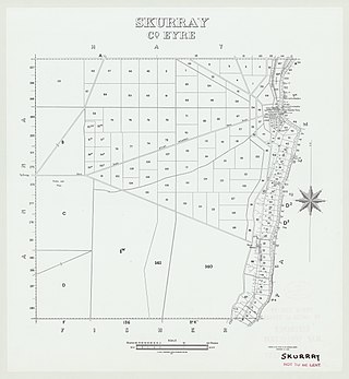
The Hundred of Skurray is a hundred within the County of Eyre, South Australia.

The District Council of Belvidere was a local government area in South Australia. It was created to provide local government in the Hundred of Belvidere on 13 December 1866 and combined into the District Council of Kapunda on 12 May 1932.
| | This South Australia geography article is a stub. You can help Wikipedia by expanding it. |