Australia Plains, South Australia

Last updated

Australia Plains
South Australia
Church and school, Australia Plains.JPG
Former Church (left) and school
Australia South Australia location map.svg
Red pog.svg
Australia Plains
Coordinates 34°05′49″S139°09′00″E / 34.097°S 139.15°E / -34.097; 139.15
Population41 (SAL 2021) [1]
Postcode(s) 5374
LGA(s) Regional Council of Goyder
State electorate(s) Stuart
Federal division(s) Grey
Localities around Australia Plains:
Robertstown Rocky Plain Geranium Plains
Point Pass Australia Plains Bower
Eudunda Peep Hill Sutherlands

Australia Plains is a rural locality in the Mid North region of South Australia, situated 127 km northeast of Adelaide in the Regional Council of Goyder. As of 2021, the population of Australia Plains was 41. [2]

Contents

Name

The locality drew its name from "Australia Huts" which appeared on old pastoral lease plans of the area. [3] Australia huts were pine and daub huts used by drovers and shepherds. [4]

History

Australia Plains is located on the traditional lands of the Ngadjuri people. [5] The Ngadjuri people have been largely overlooked in the histories of colonisation and the subsequent dispossession from their traditional lands.

"Adelaide Plains from Road to Government Farm" by Samuel Thomas Gill, 1842 Adelaide Plains from road to Government Farm, 1842 by Samuel Thomas Gill.jpg
“Adelaide Plains from Road to Government Farm” by Samuel Thomas Gill, 1842

In the 1850s, pastoralists, including the Duttons of Anlaby, took up leasehold lands in Australia Plains. While farmers hesitated to occupy these less favourable lands situated beyond Goyder’s Line, the settlement of Australia Plains gradually came into existence during the early 1880s.

A general store and saddlery opened in 1876. Australia Plains Post Office operated from 1 April 1882 to 31 May 1971. [3] In 1883, a German Lutheran church and school were established. Later, in 1894, the church was replaced by St Johannis Lutheran Church. During World War I, the school had to close down due to the prevailing anti-German sentiment at the time. [6] [7] It was replaced by a public school which operated from 1917 until 1956. St Johannis Lutheran Church closed in the 1970s, and is now a private residence. [8]

Pupils and teachers outside Australia Plains School, 1921 Pupils and teachers in a group view outside Australia Plains School, 1921.jpg
Pupils and teachers outside Australia Plains School, 1921

Demographics

In the 2021 Census, Australia Plains recorded a population of 41 people, with 60.5% being male and 39.5% female. The median age in this area was 40. There were 13 families and a total of 16 private dwellings. On average, each household consisted of 2.7 people. The median weekly household income was $850, while the median monthly mortgage repayments were $1,280. The median weekly rent was $233. Additionally, there was an average of 2.5 motor vehicles per dwelling in this region. [2]

Today

As of 2023, Australia Plains no longer has any amenities.

The Australia Plains Solar Project is an ongoing initiative that involves the installation of ground-mounted solar panels covering an area of 340 hectares. Located in Australia Plains, this project aims to harness solar energy and generate electricity. It is currently in progress and is scheduled to be completed in 2023. [9]

Related Research Articles

<span class="mw-page-title-main">Eudunda</span> Town in South Australia

Eudunda is a town in the Mid North region of South Australia, situated 110 kilometres northeast of Adelaide in the Regional Council of Goyder. As of 2021, Eudunda had a population of 815 people. Eudunda is known as the birthplace of author and educator Colin Thiele.

<span class="mw-page-title-main">Regional Council of Goyder</span> Local government area in South Australia

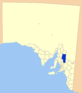
The Regional Council of Goyder is a local government area located in the Mid North region of South Australia. The council area is reliant on agriculture as a mainstay of its economy, with manufacturing and tourism also becoming prominent. The council seat is at Burra. A branch office is at Eudunda.

<span class="mw-page-title-main">Robertstown, South Australia</span> Town in South Australia

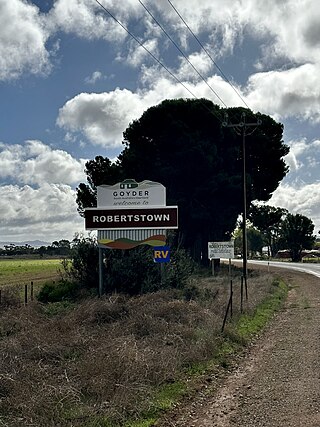
Robertstown is a town in the Mid North region of South Australia, situated 125 km north of Adelaide, in the Regional Council of Goyder. At the 2021 census, Robertstown had a population of 223 people.

<span class="mw-page-title-main">Bower, South Australia</span> Town in South Australia

Bower is a town in South Australia, approximately halfway between Eudunda and Morgan on the Thiele Highway.

<span class="mw-page-title-main">Worlds End, South Australia</span> Town in South Australia

Worlds End is a locality 18 km southeast of Burra in South Australia. It also includes the area formerly known as Lapford.

<span class="mw-page-title-main">Point Pass, South Australia</span> Town in South Australia

Point Pass is a small town in the Mid North of South Australia, 115 kilometres north of Adelaide. It is located 11 kilometres (6.8 mi) north of Eudunda, in the Regional Council of Goyder. As of 2021, the population of Point Pass was 123.

<span class="mw-page-title-main">Bundey, South Australia</span> Town in South Australia

Bundey is a locality in the Mid North region of South Australia. It is located on Goyder's Line, on the plains between Burra and Morgan in the Regional Council of Goyder. The bounded locality of Bundey corresponds to the boundaries of the cadastral Hundred of Bundey, except for the southwestern corner of the Hundred which is the northeastern corner of the locality of Geranium Plains. Bundey was named in 1878 for politician William Henry Bundey.

<span class="mw-page-title-main">Geranium Plains, South Australia</span> Town in South Australia

Geranium Plains is a small town in the Regional Council of Goyder in South Australia. The post office opened in 1894, but has since closed. There was a proposal to rename it to Iperta in 1916, but this did not go ahead.

Hallelujah Hills is a rural locality in the Mid North region of South Australia, situated in the Regional Council of Goyder.

Apoinga is a rural locality in the Mid North region of South Australia, situated in the Regional Council of Goyder.

<span class="mw-page-title-main">Neales Flat, South Australia</span> Town in South Australia

NNeales Flat is a rural locality southeast of Eudunda in the Mid North region in South Australia. It is in the Regional Council of Goyder local government area, the South Australian House of Assembly electoral district of Stuart and the Australian House of Representatives Division of Grey.

Baldina is a rural locality in the Mid North region of South Australia, situated in the Regional Council of Goyder. It was established in August 2000, when boundaries were formalised for the "long established local name".

Emu Downs is a rural locality in the Mid North region of South Australia, situated in the Regional Council of Goyder.

Ngapala is a rural locality in the Mid North region of South Australia, situated in the Regional Council of Goyder. It was established in August 2000, when boundaries were formalised for the "long established local name". It is divided between the cadastral Hundreds of English and Julia Creek.

Rocky Plain is a rural locality in the Mid North region of South Australia, situated in the Regional Council of Goyder. It was established in August 2000, when boundaries were formalised for the "long established local name".

Bright is a rural locality in the Mid North region of South Australia, situated in the Regional Council of Goyder. It was established in August 2000, when boundaries were formalised for the "long established local name". It incorporates most of the cadastral Hundred of Bright, which was proclaimed on 17 June 1875 and named for politician Henry Edward Bright.

Koonoona is a rural locality in the Mid North region of South Australia, situated in the Regional Council of Goyder. It was established in August 2000, when boundaries were formalised for the "long established local name". It occupies the north-western corner of the cadastral Hundred of Apoinga.

Brady Creek is a rural locality in the Mid North region of South Australia, situated in the Regional Council of Goyder. It was established in August 2000, when boundaries were formalised for the "long established local name" for the creek which it is centred on and named after. It is divided between the cadastral Hundreds of Apoinga and English.

Peep Hill is a rural locality in the Mid North region of South Australia, situated 120km north-east of Adelaide in the Regional Council of Goyder. It was established in August 2000, when boundaries were formalised for the "long established local name". As of 2021, Peep Hill has a population of 22 residents.

Solar River Project is a proposed photovoltaic power station planned to be built near Robertstown in South Australia. The project received development approval from the Government of South Australia in June 2018 and was expected to start construction early in 2019. However, as of November 2021, the project was still proposed to be constructed, but work on site was not expected until at least the second half of 2022.

References

  1. Australian Bureau of Statistics (28 June 2022). "Australia Plains (suburb and locality)". Australian Census 2021 QuickStats. Retrieved 28 June 2022.  OOjs UI icon edit-ltr-progressive.svg
  2. 1 2 "2021 Australia Plains, Census All persons QuickStats | Australian Bureau of Statistics". abs.gov.au. Retrieved 30 June 2023.
  3. 1 2 "Auburn - Ayliffe Crossing". manning.collections.slsa.sa.gov.au. Retrieved 30 June 2023.
  4. Robertstown (S.A. : District), ed. (1986). Emmaus to Worlds End. [Robertstown, S. Aust: District Council of Robertstown?. ISBN   978-0-9590706-1-3.
  5. "AIATSIS Map Of Indigenous Australia | Reconciliation SA". reconciliationsa.org.au. 20 August 2021. Retrieved 30 June 2023.
  6. "CLOSING GERMAN SCHOOLS". Daily Herald . Vol. 8, no. 2260. South Australia. 18 June 1917. p. 3. Retrieved 24 December 2016 via National Library of Australia.
  7. Dreckow, Betty (1986). Hills, Valley and Plains: History of the Eudunda District. p. 142.
  8. Design, UBC Web. "St Johannis Lutheran Church - Former | Churches Australia". www.churchesaustralia.org. Retrieved 30 June 2023.
  9. "Australia Plains Solar Farm |" . Retrieved 30 June 2023.