Peep Hill, South Australia

Last updated

Peep Hill
South Australia
Australia South Australia location map.svg
Red pog.svg
Peep Hill
Coordinates 34°9′S139°9′E / 34.150°S 139.150°E / -34.150; 139.150
Population22 (SAL 2021) [1]
Postcode(s) 5374 [2]
Elevation283 m (928 ft)
LGA(s) Regional Council of Goyder
State electorate(s) Stuart [2]
Federal division(s) Grey [2]
Localities around Peep Hill:
Eudunda Australia Plains Australia Plains
Eudunda Peep Hill Sutherlands
Eudunda Eudunda Neales Flat
FootnotesCoordinates [3] Elevation [4]

Peep Hill is a rural locality in the Mid North region of South Australia, situated 120km north-east of Adelaide in the Regional Council of Goyder. [2] It was established in August 2000, when boundaries were formalised for the "long established local name". [3] As of 2021, Peep Hill has a population of 22 residents. [5]

Contents

Etymology

Peep Hill is reported to be named for "a round hill in the last range towards the east". [6]

History

Peep Hill is located on the traditional lands of the Ngadjuri people. [7] The Ngadjuri have been largely overlooked in the histories of colonisation and the subsequent dispossession from their traditional lands.

In 1876, farmer Johann Gottlieb Dohnt was recorded as being one of the first European settlers at Peep Hill. [8] Two years later, in 1878, Peep Hill was described as "no township, but simply a small settlement." [9]

The Peep Hill School, originally named the Deep Creek School, was established in 1883. It closed down in 1939 due to small student numbers. The school building was demolished in 1950 and, by 1986, it was noted to be a pile of rubble. [10] [11]

Peep Hill School memorial and ruins Peep Hill School Memorial and Ruins.jpg
Peep Hill School memorial and ruins

A Lutheran congregation was officially formed in Peep Hill in 1888, although services had been conducted there since 1880. Initially, the congregation worshipped in the school until St Michael's Lutheran Church was opened in 1890. [12] The church underwent renovations in 1936 and transitioned from the Point Pass Parish to the Eudunda Parish in 1966. [10] The church continues in operation, and is now part of the Eudunda Robertstown Lutheran Parish. [13]

St Michael's Lutheran Church St Michael's Lutheran Church, Peep Hill.jpg
St Michael's Lutheran Church

Peep Hill Post Office opened on 1 July 1883 and closed on 1 November 1930. [14] The town formerly had a railway siding on the Morgan line, the Deep Creek station. [4]

Demographics

As of 2021, Peep Hill is a small community with a total population of 22 people. The majority of the population is male, accounting for 64.3%, while females make up 35.7% of the population. The median age of the residents is 44 years. The community has a total of 9 private dwellings, with an average of 2.6 people per household. On average, each dwelling in Peep Hill has 4.3 motor vehicles. The median weekly household income is $1,374, and the median monthly mortgage repayments are $999. [5]

Flora

Dodonaea subglandulifera , also known as Peep Hill hop bush, is a species of plant in the Sapindaceae family. It is native to south-eastern South Australia. Peep Hill hop bush is listed as nationally endangered, with an estimated 45,000 to 50,000 plants remaining. [15]

Peep Hill hop bush Dodonaea subglandulifera 02.jpg
Peep Hill hop bush

Related Research Articles

<span class="mw-page-title-main">Eudunda</span> Town in South Australia

Eudunda is a town in the Mid North region of South Australia, situated 110 kilometres northeast of Adelaide in the Regional Council of Goyder. As of 2021, Eudunda had a population of 815 people. Eudunda is known as the birthplace of author and educator Colin Thiele.

<span class="mw-page-title-main">Regional Council of Goyder</span> Local government area in South Australia

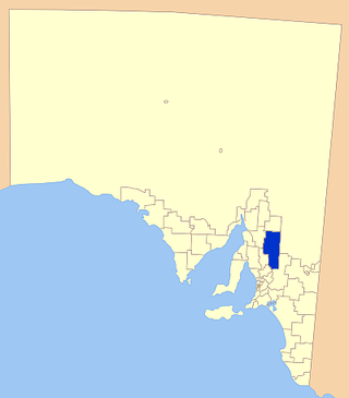
The Regional Council of Goyder is a local government area located in the Mid North region of South Australia. The council area is reliant on agriculture as a mainstay of its economy, with manufacturing and tourism also becoming prominent. The council seat is at Burra. A branch office is at Eudunda.

<span class="mw-page-title-main">Robertstown, South Australia</span> Town in South Australia

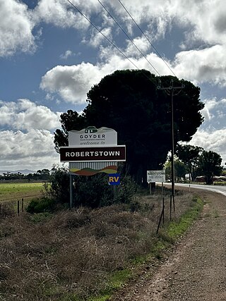
Robertstown is a town in the Mid North region of South Australia, situated 125 km north of Adelaide, in the Regional Council of Goyder. At the 2021 census, Robertstown had a population of 223 people.

<span class="mw-page-title-main">Dutton, South Australia</span> Town in South Australia

Dutton is a settlement in South Australia. The small township lies approximately six kilometres (3.7 mi) north of Truro on the Eudunda Road. It was first laid out in 1866 and lots were advertised for sale in the German-language newspaper Südaustralische Zeitung.

<span class="mw-page-title-main">Bower, South Australia</span> Town in South Australia

Bower is a town in South Australia, approximately halfway between Eudunda and Morgan on the Thiele Highway.

<span class="mw-page-title-main">Hansborough, South Australia</span> Town in South Australia

Hansborough is a locality along the former Morgan railway line adjacent to the Thiele Highway, in South Australia's Mid North region. It is situated 9 kilometres south-west of Eudunda and 18 kilometres north-east of Kapunda. The Light River runs through the locality.

<span class="mw-page-title-main">Morgan railway line</span> Former railway line in South Australia

The Morgan railway line or North-West Bend railway was a railway line on the South Australian Railways network.

<span class="mw-page-title-main">Steinfeld, South Australia</span> Town in South Australia

Steinfeld is a locality in South Australia on the plains east of the Mount Lofty Ranges, and north of the Sturt Highway. The village of Steinfeld was established in the 19th century. It was renamed to Stonefield in 1918 as many places with German or German-sounding names were changed around World War I. The name reverted to Steinfeld in 1986.

<span class="mw-page-title-main">Point Pass, South Australia</span> Town in South Australia

Point Pass is a small town in the Mid North of South Australia, 115 kilometres north of Adelaide. It is located 11 kilometres (6.8 mi) north of Eudunda, in the Regional Council of Goyder. As of 2021, the population of Point Pass was 123.

<span class="mw-page-title-main">Bundey, South Australia</span> Town in South Australia

Bundey is a locality in the Mid North region of South Australia. It is located on Goyder's Line, on the plains between Burra and Morgan in the Regional Council of Goyder. The bounded locality of Bundey corresponds to the boundaries of the cadastral Hundred of Bundey, except for the southwestern corner of the Hundred which is the northeastern corner of the locality of Geranium Plains. Bundey was named in 1878 for politician William Henry Bundey.

<span class="mw-page-title-main">Australia Plains, South Australia</span> Town in South Australia

Australia Plains is a rural locality in the Mid North region of South Australia, situated 127 km northeast of Adelaide in the Regional Council of Goyder. As of 2021, the population of Australia Plains was 41.

<span class="mw-page-title-main">Geranium Plains, South Australia</span> Town in South Australia

Geranium Plains is a small town in the Regional Council of Goyder in South Australia. The post office opened in 1894, but has since closed. There was a proposal to rename it to Iperta in 1916, but this did not go ahead.

<span class="mw-page-title-main">Neales Flat, South Australia</span> Town in South Australia

NNeales Flat is a rural locality southeast of Eudunda in the Mid North region in South Australia. It is in the Regional Council of Goyder local government area, the South Australian House of Assembly electoral district of Stuart and the Australian House of Representatives Division of Grey.

The District Council of Neales was a local government area in South Australia from 1878 to 1932. The main town and council seat was Eudunda.

Julia is a locality in the Mid North of South Australia, 111 kilometres North of Adelaide, the state capital. The town is located 10 kilometres (6.2 mi) north of Eudunda, in the Regional Council of Goyder. It was created in August 2000, with boundaries formalised for the long established local name.

Emu Downs is a rural locality in the Mid North region of South Australia, situated in the Regional Council of Goyder.

Ngapala is a rural locality in the Mid North region of South Australia, situated in the Regional Council of Goyder. It was established in August 2000, when boundaries were formalised for the "long established local name". It is divided between the cadastral Hundreds of English and Julia Creek.

Buchanan is a rural locality in the Mid North region of South Australia, situated in the Regional Council of Goyder. It was established in August 2000, when boundaries were formalised for the "long established local name".

Frankton is a rural locality in the Mid North region of South Australia, situated in the Regional Council of Goyder and Mid Murray Council. The section within the Goyder council was established in August 2000, when boundaries were formalised for the "long established local name"; the section within the Mid Murray council was added in March 2003. It is believed to be named after the son of two early residents, Mr. and Mrs. Rice.

Hampden is a rural locality in the Mid North region of South Australia, situated in the Regional Council of Goyder. It was established in August 2000, when boundaries were formalised for the "long established local name". It was named for William Hampden Dutton, brother of Frederick Dutton, who established Anlaby Station.

References

  1. Australian Bureau of Statistics (28 June 2022). "Peep Hill (Suburb and Locality)". Australian Census 2021 QuickStats. Retrieved 28 June 2022.  OOjs UI icon edit-ltr-progressive.svg
  2. 1 2 3 4 "Search result(s) for Peep Hill, 5374". Location SA Map Viewer. Government of South Australia. Retrieved 14 December 2016.
  3. 1 2 "Search result(s) for Peep Hill, 5374". Property Location Browser. Government of South Australia. Archived from the original on 12 October 2016. Retrieved 26 November 2016.
  4. 1 2 "Search result(s) for Deep Creek Railway Station". Location SA Map Viewer. Government of South Australia. Retrieved 14 December 2016.
  5. 1 2 "2021 Peep Hill, Census All persons QuickStats | Australian Bureau of Statistics". www.abs.gov.au. Retrieved 26 June 2023.
  6. Dreckow, Betty (1986). Hills, Valley and Plains: History of the Eudunda District. p. 7.
  7. Studies, Australian Institute of Aboriginal and Torres Strait Islander (10 November 2022). "Map of Indigenous Australia". aiatsis.gov.au. Retrieved 26 June 2023.
  8. "MR. J. G. DOHNT". Chronicle. 26 January 1929. Retrieved 27 June 2023.
  9. "SCHOOL NEAR EUDUNDA". South Australian Chronicle and Weekly Mail. 21 December 1878. Retrieved 27 June 2023.
  10. 1 2 Dreckow, Betty (1986). Hills, Valley and Plains: History of the Eudunda District. p. 388.
  11. "Peep Hill". Flinders Ranges Research. Retrieved 24 December 2016.
  12. "KAPUNDA LOCAL BOARD OF ADVICE". Kapunda Herald. 11 May 1883. Retrieved 27 June 2023.
  13. "Eudunda Robertstown Lutheran Parish". 6 February 2017. Retrieved 11 February 2017.
  14. "Peep Hill". Post Office Reference. Premier Postal. Retrieved 24 December 2016.
  15. "Native plant - Peep Hill hop-bush - Department of Environment, Water…". Landscape South Australia - Murraylands and Riverland. Retrieved 26 June 2023.